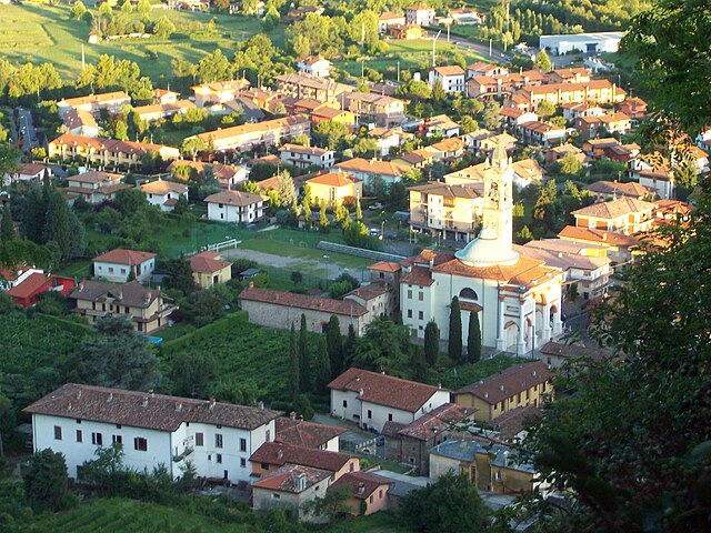
Gorle (Gorle)
.svg)
- Italian comune
 Hiking in Gorle
Gorle, a small municipality in the Lombardy region of Italy, is located near the city of Bergamo. While it's not as internationally renowned for hiking as some of its neighboring regions, it still offers opportunities for outdoor activities in a picturesque setting.
Hiking Opportunities in and Around Gorle:
-
Surrounding Nature: The area around Gorle features beautiful landscapes, including hills, woodlands, and lakes. The nearby Bergamo hills offer various trails that cater to different skill levels.
-
Sentiero dei Tedeschi: This is a well-known hiking trail that runs through the nearby hills and is part of the larger network of trails in the region. It offers scenic views and a mix of terrains.
-
Laghetto di Gorle: This little lake is a nice spot for a leisurely walk or picnic. The surrounding area has paths suitable for casual strolling and observing local wildlife.
-
Monte Canto: Close to Gorle, this area provides hiking trails that offer panoramic views over Bergamo and the surrounding valleys. There are various paths leading up to Monte Canto, making it a great place for both short and longer hikes.
-
Local Parks and Green Areas: Gorle has several parks that can be explored, providing a chance for families and casual walkers to enjoy the outdoors without venturing too far into the wilderness.
Tips for Hiking in Gorle:
-
Seasonal Considerations: Spring and fall are ideal for hiking because of milder weather. Summer can be hot, while winter may bring snow to the higher elevations.
-
Gear Up: Wear appropriate hiking footwear and dress in layers, especially since temperatures can change rapidly in the mountains.
-
Stay Hydrated: Always carry enough water, especially on longer hikes.
-
Local Guidance: If you're new to the area, consider reaching out to local hiking clubs or guides for the best trail recommendations and safety tips.
-
Respect Nature: Follow Leave No Trace principles, such as staying on marked trails and carrying out all trash.
While Gorle might not be a major hiking destination, it's a charming place to explore the natural beauty of Lombardy. Be sure to check local resources or maps for updated trail information before you go!
- Country:

- Postal Code: 24020
- Local Dialing Code: 035
- Licence Plate Code: BG
- Coordinates: 45° 42' 14" N, 9° 43' 9" E


- GPS tracks (wikiloc): [Link]
- AboveSeaLevel: 268 м m
- Area: 2.52 sq km
- Population: 6557
- Web site: http://www.comune.gorle.bg.it
- Wikipedia en: wiki(en)
- Wikipedia: wiki(it)
- Wikidata storage: Wikidata: Q101145
- Wikipedia Commons Gallery: [Link]
- Wikipedia Commons Category: [Link]
- Freebase ID: [/m/0gjbmg]
- GeoNames ID: Alt: [6537152]
- VIAF ID: Alt: [236101608]
- OSM relation ID: [45787]
- WOEID: [716286]
- UN/LOCODE: [ITGOE]
- ISTAT ID: 016115
- Italian cadastre code: E103
Shares border with regions:


Pedrengo
- Italian comune
Hiking in Pedrengo
Pedrengo is a charming town in the province of Bergamo, Italy, known for its beautiful landscapes and proximity to the Bergamasque Alps, making it an excellent starting point for hiking enthusiasts. The area offers a variety of trails suitable for different skill levels, ranging from leisurely walks to more challenging hikes....
- Country:
- Postal Code: 24066
- Local Dialing Code: 035
- Licence Plate Code: BG
- Coordinates: 45° 41' 54" N, 9° 44' 2" E
- GPS tracks (wikiloc): [Link]
- AboveSeaLevel: 262 м m
- Area: 3.6 sq km
- Population: 6026
- Web site: [Link]


Ranica
- Italian comune
Hiking in Ranica
Ranica is a picturesque area located in Italy, known for its stunning natural landscapes, making it a great destination for hiking enthusiasts. Here are some key points to consider if you’re planning to hike in Ranica:...
- Country:
- Postal Code: 24020
- Local Dialing Code: 035
- Licence Plate Code: BG
- Coordinates: 45° 44' 0" N, 9° 43' 0" E
- GPS tracks (wikiloc): [Link]
- AboveSeaLevel: 293 м m
- Area: 4.06 sq km
- Population: 5945
- Web site: [Link]

Scanzorosciate
- Italian comune
Hiking in Scanzorosciate
Scanzorosciate is a charming town located in the Lombardy region of northern Italy, near the city of Bergamo. The area offers a variety of hiking opportunities that allow you to explore its stunning landscapes, nature, and cultural heritage....
- Country:
- Postal Code: 24020
- Local Dialing Code: 035
- Licence Plate Code: BG
- Coordinates: 45° 42' 41" N, 9° 44' 9" E
- GPS tracks (wikiloc): [Link]
- AboveSeaLevel: 297 м m
- Area: 10.69 sq km
- Population: 10076
- Web site: [Link]


Seriate
- Italian comune
Hiking in Seriate
Seriate is a town located in the Lombardy region of northern Italy, close to the city of Bergamo. While it may not be as widely recognized for hiking as some other locations in the Italian Alps, it does have access to several beautiful hiking trails and natural landscapes that outdoor enthusiasts can enjoy....
- Country:
- Postal Code: 24068
- Local Dialing Code: 035
- Licence Plate Code: BG
- Coordinates: 45° 41' 5" N, 9° 43' 4" E
- GPS tracks (wikiloc): [Link]
- AboveSeaLevel: 247 м m
- Area: 12.53 sq km
- Population: 25358
- Web site: [Link]


Torre Boldone
- Italian comune
Hiking in Torre Boldone
Torre Boldone is a charming municipality located in the province of Bergamo in Lombardy, Italy. Nestled at the foothills of the beautiful Alps, it offers diverse hiking opportunities that cater to various skill levels....
- Country:
- Postal Code: 24020
- Local Dialing Code: 035
- Licence Plate Code: BG
- Coordinates: 45° 43' 0" N, 9° 42' 0" E
- GPS tracks (wikiloc): [Link]
- AboveSeaLevel: 280 м m
- Area: 3.48 sq km
- Population: 8755
- Web site: [Link]


Bergamo
- Italian comune
Hiking in Bergamo
Bergamo, located in northern Italy, is surrounded by stunning landscapes and offers a variety of hiking opportunities for all skill levels. The area is characterized by its beautiful hills, mountains, and the iconic Alps in the distance. Here’s a guide to hiking in Bergamo:...
- Country:
- Postal Code: 24129; 24128; 24127; 24126; 24125; 24124; 24123; 24122; 24121
- Local Dialing Code: 035
- Licence Plate Code: BG
- Coordinates: 45° 41' 42" N, 9° 40' 12" E
- GPS tracks (wikiloc): [Link]
- AboveSeaLevel: 249 м m
- Area: 39 sq km
- Population: 119806
- Web site: [Link]