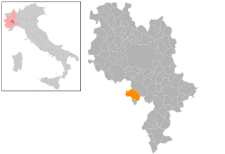
Govone (Govone)
- Italian comune
 Hiking in Govone
Govone is a small town located in the Piedmont region of Italy, known for its beautiful landscapes, vineyards, and historical sites. While it may not be as well-known as some larger hiking destinations, it offers several opportunities for scenic walks and hikes that allow you to enjoy the local flora and fauna, as well as stunning views of the surrounding countryside.
Here are some highlights for hiking in and around Govone:
-
Vineyard Trails: The region is famous for its wine production, particularly Barbera and Moscato. Hiking through the vineyards can be a delightful experience, where you can enjoy views of rolling hills and valleys, particularly during autumn when the leaves change color.
-
Nearby Parks: Consider exploring the nearby parks and natural reserves. The "Parco della Rimembranza," for instance, offers trails that weave through wooded areas, perfect for serene hikes.
-
Castles and Historical Sites: As you hike, you may come across historical sites such as Castello di Govone, which can add an interesting cultural aspect to your trek. Many trails can lead you to these sites, blending nature and history.
-
Hiking Maps and Local Guidance: It’s advisable to seek out local maps or guides to help navigate the trails, as well as checking in with local tourism offices for the latest information on trail conditions and recommendations for hike lengths and difficulty levels.
-
Best Time to Hike: The best times for hiking in this area are usually spring and fall, when the weather is mild and the scenery is particularly beautiful. Summer can be warm, so early morning or late afternoon hikes might be more comfortable.
-
Wildlife Watching: While hiking, keep an eye out for local wildlife, including various bird species and other animals that inhabit the region.
If you're planning a hike in Govone, ensure that you're well-prepared with suitable footwear, plenty of water, and snacks. Always consider the weather conditions and your own fitness level when choosing hiking routes. Enjoy your time exploring the natural beauty of Govone!
- Country:

- Postal Code: 12040
- Local Dialing Code: 0173
- Licence Plate Code: CN
- Coordinates: 44° 48' 0" N, 8° 6' 0" E


- GPS tracks (wikiloc): [Link]
- AboveSeaLevel: 301 м m
- Area: 18.91 sq km
- Population: 2235
- Web site: http://www.comune.govone.cn.it
- Wikipedia en: wiki(en)
- Wikipedia: wiki(it)
- Wikidata storage: Wikidata: Q20096
- Wikipedia Commons Category: [Link]
- Freebase ID: [/m/0gb9s3]
- GeoNames ID: Alt: [6543832]
- VIAF ID: Alt: [132979095]
- OSM relation ID: [43612]
- UN/LOCODE: [ITGVN]
- ISTAT ID: 004099
- Italian cadastre code: E118
Shares border with regions:

Castagnole delle Lanze
- Italian comune
Hiking in Castagnole delle Lanze
Castagnole delle Lanze is a charming village located in the Piedmont region of Italy, nestled in the hills of the Langhe area. This region is renowned for its picturesque landscapes, vineyards, and rich history, making it an excellent destination for hiking enthusiasts....
- Country:
- Postal Code: 14054
- Local Dialing Code: 0141
- Licence Plate Code: AT
- Coordinates: 44° 45' 8" N, 8° 9' 5" E
- GPS tracks (wikiloc): [Link]
- AboveSeaLevel: 271 м m
- Area: 21.57 sq km
- Population: 3770
- Web site: [Link]


Costigliole d'Asti
- Italian comune
Hiking in Costigliole d'Asti
Costigliole d'Asti, located in the Piedmont region of Italy, is known for its beautiful landscapes, rolling hills, vineyards, and charming villages. Hiking in this area offers a wonderful opportunity to explore the stunning natural surroundings, rich history, and local culture....
- Country:
- Postal Code: 14055
- Local Dialing Code: 0141
- Licence Plate Code: AT
- Coordinates: 44° 47' 6" N, 8° 10' 55" E
- GPS tracks (wikiloc): [Link]
- AboveSeaLevel: 242 м m
- Area: 36.94 sq km
- Population: 5822
- Web site: [Link]


San Damiano d'Asti
- Italian comune
Hiking in San Damiano d'Asti
San Damiano d'Asti, located in the Piedmont region of Italy, offers a charming landscape that is well-suited for hiking enthusiasts. The area is characterized by rolling hills, vineyards, and scenic countryside, making it an ideal spot for various hiking trails. Here are some highlights and tips for hiking in and around San Damiano d'Asti:...
- Country:
- Postal Code: 14015
- Local Dialing Code: 0141
- Licence Plate Code: AT
- Coordinates: 44° 50' 4" N, 8° 3' 53" E
- GPS tracks (wikiloc): [Link]
- AboveSeaLevel: 179 м m
- Area: 47.87 sq km
- Population: 8347
- Web site: [Link]
San Martino Alfieri
- Italian comune
Hiking in San Martino Alfieri
San Martino Alfieri is located in the Piedmont region of Italy, known for its picturesque landscapes, vineyards, and historic sites. Hiking in this area provides an opportunity to explore the scenic beauty of the rolling hills, charming villages, and sprawling vineyards characteristic of the region....
- Country:
- Postal Code: 14010
- Local Dialing Code: 0141
- Licence Plate Code: AT
- Coordinates: 44° 49' 8" N, 8° 6' 40" E
- GPS tracks (wikiloc): [Link]
- AboveSeaLevel: 257 м m
- Area: 7.21 sq km
- Population: 658
- Web site: [Link]
Magliano Alfieri
- Italian comune
Hiking in Magliano Alfieri
Magliano Alfieri is a charming village located in the Piedmont region of northwestern Italy, surrounded by beautiful landscapes, vineyards, and rolling hills. Hiking in this area offers a mix of scenic views, cultural heritage, and a chance to explore the local flora and fauna....
- Country:
- Postal Code: 12050
- Local Dialing Code: 0173
- Licence Plate Code: CN
- Coordinates: 44° 46' 0" N, 8° 4' 0" E
- GPS tracks (wikiloc): [Link]
- AboveSeaLevel: 328 м m
- Area: 9.5 sq km
- Population: 2147
- Web site: [Link]

Priocca
- Italian comune
Hiking in Priocca
Priocca is a small municipality located in the Piedmont region of Italy, surrounded by beautiful landscapes ideal for hiking and outdoor activities. The area features picturesque vineyards, rolling hills, and scenic views that are quintessential to the region....
- Country:
- Postal Code: 12040
- Local Dialing Code: 0173
- Licence Plate Code: CN
- Coordinates: 44° 47' 0" N, 8° 4' 0" E
- GPS tracks (wikiloc): [Link]
- AboveSeaLevel: 253 м m
- Area: 9.03 sq km
- Population: 2001
- Web site: [Link]