San Martino Alfieri (San Martino Alfieri)

- Italian comune
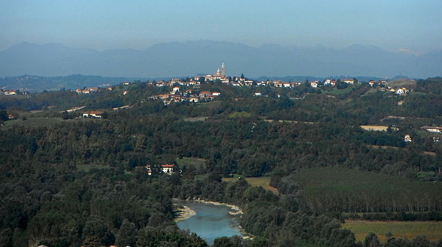
 Hiking in San Martino Alfieri
San Martino Alfieri is located in the Piedmont region of Italy, known for its picturesque landscapes, vineyards, and historic sites. Hiking in this area provides an opportunity to explore the scenic beauty of the rolling hills, charming villages, and sprawling vineyards characteristic of the region.
Hiking Trails and Routes
-
Local Trails: There are several local trails around San Martino Alfieri that vary in difficulty. Many lead through vineyards, offering stunning views of the countryside and opportunities to taste local wines at wineries.
-
Cultural Walks: Some trails may link historical sites, such as castles and churches, allowing you to not only enjoy nature but also immerse yourself in the local culture.
-
Parks and Nature Reserves: Nearby nature parks also offer a range of trails suitable for hiking. Exploring these areas can lead to encounters with local flora and fauna.
Best Time to Hike
- Spring and Fall: These seasons are typically the best times to hike in San Martino Alfieri due to the mild temperatures and blooming/orange foliage, making for a pleasant experience.
- Summer: While summer can be hot, early morning hikes can be very enjoyable. Just remember to stay hydrated!
Hiking Tips
- Footwear: Wear sturdy hiking boots to navigate uneven terrain.
- Hydration: Always carry enough water, especially in warmer months.
- Maps and Guides: Consider bringing a physical map or downloading a hiking app, as not all trails may be well-marked.
- Respect Nature: Follow Leave No Trace principles to help preserve the beautiful environment around San Martino Alfieri.
Conclusion
Hiking in and around San Martino Alfieri is a rewarding experience, allowing you to connect with nature while also enjoying the rich cultural heritage of the Piedmont region. Whether you're a seasoned hiker or a beginner, there are trails suited to all levels, making it a perfect destination for outdoor enthusiasts.
- Country:

- Postal Code: 14010
- Local Dialing Code: 0141
- Licence Plate Code: AT
- Coordinates: 44° 49' 8" N, 8° 6' 40" E


- GPS tracks (wikiloc): [Link]
- AboveSeaLevel: 257 м m
- Area: 7.21 sq km
- Population: 658
- Web site: http://www.comune.sanmartinoalfieri.at.it/
- Wikipedia en: wiki(en)
- Wikipedia: wiki(it)
- Wikidata storage: Wikidata: Q17861
- Wikipedia Commons Category: [Link]
- Freebase ID: [/m/0gbjbs]
- GeoNames ID: Alt: [6542846]
- VIAF ID: Alt: [244352975]
- OSM relation ID: [43676]
- UN/LOCODE: [ITSMF]
- ISTAT ID: 005099
- Italian cadastre code: H987
Shares border with regions:

Antignano
- Italian comune
Hiking in Antignano
Antignano, a quaint village located in the province of Livorno in Tuscany, Italy, offers a unique hiking experience characterized by its scenic landscapes, traditional architecture, and proximity to the beautiful Tuscan countryside and coastal areas....
- Country:
- Postal Code: 14010
- Local Dialing Code: 0141
- Licence Plate Code: AT
- Coordinates: 44° 50' 43" N, 8° 8' 6" E
- GPS tracks (wikiloc): [Link]
- AboveSeaLevel: 260 м m
- Area: 10.86 sq km
- Population: 971
- Web site: [Link]


Costigliole d'Asti
- Italian comune
Hiking in Costigliole d'Asti
Costigliole d'Asti, located in the Piedmont region of Italy, is known for its beautiful landscapes, rolling hills, vineyards, and charming villages. Hiking in this area offers a wonderful opportunity to explore the stunning natural surroundings, rich history, and local culture....
- Country:
- Postal Code: 14055
- Local Dialing Code: 0141
- Licence Plate Code: AT
- Coordinates: 44° 47' 6" N, 8° 10' 55" E
- GPS tracks (wikiloc): [Link]
- AboveSeaLevel: 242 м m
- Area: 36.94 sq km
- Population: 5822
- Web site: [Link]


San Damiano d'Asti
- Italian comune
Hiking in San Damiano d'Asti
San Damiano d'Asti, located in the Piedmont region of Italy, offers a charming landscape that is well-suited for hiking enthusiasts. The area is characterized by rolling hills, vineyards, and scenic countryside, making it an ideal spot for various hiking trails. Here are some highlights and tips for hiking in and around San Damiano d'Asti:...
- Country:
- Postal Code: 14015
- Local Dialing Code: 0141
- Licence Plate Code: AT
- Coordinates: 44° 50' 4" N, 8° 3' 53" E
- GPS tracks (wikiloc): [Link]
- AboveSeaLevel: 179 м m
- Area: 47.87 sq km
- Population: 8347
- Web site: [Link]

Govone
- Italian comune
Hiking in Govone
Govone is a small town located in the Piedmont region of Italy, known for its beautiful landscapes, vineyards, and historical sites. While it may not be as well-known as some larger hiking destinations, it offers several opportunities for scenic walks and hikes that allow you to enjoy the local flora and fauna, as well as stunning views of the surrounding countryside....
- Country:
- Postal Code: 12040
- Local Dialing Code: 0173
- Licence Plate Code: CN
- Coordinates: 44° 48' 0" N, 8° 6' 0" E
- GPS tracks (wikiloc): [Link]
- AboveSeaLevel: 301 м m
- Area: 18.91 sq km
- Population: 2235
- Web site: [Link]