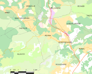
Gréasque (Gréasque)

- commune in Bouches-du-Rhône, France
 Hiking in Gréasque
Gréasque, a charming commune in the Bouches-du-Rhône department of southern France, offers various hiking opportunities that showcase its beautiful landscapes and rich natural heritage. Nestled near the Sainte-Victoire mountain range, the area is characterized by picturesque hills, limestone formations, and Mediterranean vegetation. Here are some notable aspects of hiking in and around Gréasque:
Hiking Trails
-
Local Trails: Gréasque boasts several local trails that are suitable for various skill levels. These trails often take you through lush forests, rocky outcrops, and scenic viewpoints that highlight the stunning scenery of the region.
-
Sainte-Victoire Mountain: Located nearby, the famous Sainte-Victoire offers a variety of trails that attract hikers from all over. Exploring this area allows you to enjoy breathtaking panoramas as well as visit historical landmarks.
-
Cézanne's Trail: This is a popular route that connects to various sites that inspired the artist Paul Cézanne, giving hikers a blend of art history and natural beauty.
Tips for Hiking in Gréasque
-
Best Time to Hike: Spring and fall are ideal for hiking in this region, as the temperatures are mild and the flora is particularly vibrant.
-
Gear: Wear appropriate hiking boots and carry plenty of water, especially during the warmer months. A sun hat and sunscreen are also recommended due to the Mediterranean climate.
-
Navigation: While many trails are well-marked, carrying a map or using a GPS-enabled app can enhance your experience and ensure you stay on track.
-
Respect Nature: Follow the Leave No Trace principles, stay on marked paths, and be mindful of local wildlife and flora.
-
Local Resources: Check in with local tourist offices or hiking clubs for up-to-date trail information, guided hikes, and community events.
Attractions Nearby
- Montagne de Regarde: A great spot for hiking, offering beautiful vistas and opportunities for photography.
- Cézanne's Studio: An enriching cultural visit nearby for those interested in the region’s artistic heritage.
Whether you're an experienced hiker or a beginner, Gréasque and its surroundings have something to offer everyone. Enjoy the stunning landscapes and the tranquil ambiance of this beautiful part of France!
- Country:

- Postal Code: 13850
- Coordinates: 43° 25' 50" N, 5° 32' 21" E


- GPS tracks (wikiloc): [Link]
- Area: 6.15 sq km
- Population: 4111
- Web site: http://www.ville-greasque.fr
- Wikipedia en: wiki(en)
- Wikipedia: wiki(fr)
- Wikidata storage: Wikidata: Q676005
- Wikipedia Commons Category: [Link]
- Freebase ID: [/m/0281nwy]
- Freebase ID: [/m/0281nwy]
- GeoNames ID: Alt: [3014767]
- GeoNames ID: Alt: [3014767]
- SIREN number: [211300462]
- SIREN number: [211300462]
- BnF ID: [15247328x]
- BnF ID: [15247328x]
- VIAF ID: Alt: [242291405]
- VIAF ID: Alt: [242291405]
- MusicBrainz area ID: [17aef6bb-45cd-403a-be40-4a9a0e38067f]
- MusicBrainz area ID: [17aef6bb-45cd-403a-be40-4a9a0e38067f]
- INSEE municipality code: 13046
- INSEE municipality code: 13046
Shares border with regions:


Belcodène
- commune in Bouches-du-Rhône, France
Hiking in Belcodène
Belcodène is a charming commune located in the Bouches-du-Rhône department in southern France, near the Sainte-Baume mountain range. The natural scenery around Belcodène offers a wonderful setting for hiking enthusiasts, combining picturesque landscapes with diverse flora and fauna....
- Country:
- Postal Code: 13720
- Coordinates: 43° 25' 35" N, 5° 35' 21" E
- GPS tracks (wikiloc): [Link]
- Area: 12.97 sq km
- Population: 1906
- Web site: [Link]

Peypin
- commune in Bouches-du-Rhône, France
Hiking in Peypin
Peypin is a charming commune located in the Bouches-du-Rhône department in the Provence-Alpes-Côte d'Azur region of France. It offers beautiful landscapes and a variety of hiking opportunities, making it a great destination for outdoor enthusiasts....
- Country:
- Postal Code: 13124
- Coordinates: 43° 23' 9" N, 5° 34' 42" E
- GPS tracks (wikiloc): [Link]
- Area: 13.35 sq km
- Population: 5454
- Web site: [Link]


Mimet
- commune in Bouches-du-Rhône, France
Hiking in Mimet
Mimet, a picturesque village located in the Provence-Alpes-Côte d'Azur region of France, is known for its stunning landscapes and diverse hiking opportunities. Nestled at the foot of the Sainte-Baume mountain range, Mimet offers a variety of trails suitable for different skill levels, making it an excellent destination for hikers....
- Country:
- Postal Code: 13105
- Coordinates: 43° 24' 49" N, 5° 30' 20" E
- GPS tracks (wikiloc): [Link]
- Area: 18.7 sq km
- Population: 4607


Saint-Savournin
- commune in Bouches-du-Rhône, France
Hiking in Saint-Savournin
Saint-Savournin is a charming village located in the Bouches-du-Rhône department of southern France, known for its scenic landscapes and proximity to the Sainte-Baume mountain range. Hiking in and around Saint-Savournin offers a variety of trails that cater to different skill levels, with beautiful views of the surrounding countryside and the Mediterranean climate providing pleasant hiking conditions for most of the year....
- Country:
- Postal Code: 13119
- Coordinates: 43° 24' 23" N, 5° 31' 39" E
- GPS tracks (wikiloc): [Link]
- Area: 5.89 sq km
- Population: 3315
- Web site: [Link]


Fuveau
- commune in Bouches-du-Rhône, France
Hiking in Fuveau
Fuveau is a charming commune located in the Bouches-du-Rhône department of the Provence-Alpes-Côte d'Azur region in southeastern France. It's surrounded by beautiful landscapes that offer a variety of hiking opportunities....
- Country:
- Postal Code: 13710
- Coordinates: 43° 27' 8" N, 5° 33' 42" E
- GPS tracks (wikiloc): [Link]
- Area: 30.02 sq km
- Population: 9756
- Web site: [Link]