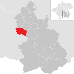
Steinbach am Ziehberg (Steinbach am Ziehberg)
- municipality in Austria
 Hiking in Steinbach am Ziehberg
Steinbach am Ziehberg, located in Austria, is a wonderful destination for hiking enthusiasts. Nestled in the stunning Salzkammergut region, it offers beautiful landscape features including mountains, forests, and meadows.
Hiking Trails
There are various trails suitable for different skill levels, from easy walks to more challenging hikes. Some popular routes include:
-
Panoramic Trails: These trails provide breathtaking views of the surrounding mountains and valleys. They often lead to viewpoints where you can take a break and enjoy the scenery.
-
Forest Trails: The area is rich in wooded areas, providing shaded pathways ideal for warmer days.
-
Mountain Ascents: For more experienced hikers, there are routes that lead to nearby peaks. Prepare for steeper inclines and more rugged terrain.
Seasonal Highlights
- Spring and Summer: Ideal for wildflower spotting and wildlife watching. You might see local fauna such as deer or various bird species.
- Autumn: The changing colors of the foliage are stunning, making it a perfect time for photography.
- Winter: Snow-covered landscapes can offer a different kind of beauty, and some trails may be suitable for snowshoeing or winter hiking.
Tips for Hikers
- Preparation: Always check the weather forecast before heading out. The weather can change rapidly in the mountains.
- Gear: Wear appropriate hiking shoes and bring a map or GPS device. It's also wise to carry plenty of water and snacks.
- Local Guidance: Consider joining guided hikes if you're unfamiliar with the area. Local guides can offer insights into the terrain and flora and fauna.
Safety
Stay on marked trails to protect the environment and ensure your safety. It's also important to inform someone of your hiking plans, especially if you’re heading out on your own.
Steinbach am Ziehberg offers a fantastic hiking experience for nature lovers, with a mix of scenic beauty, tranquility, and adventure!
- Country:

- Postal Code: 4562
- Local Dialing Code: 07582
- Licence Plate Code: KI
- Coordinates: 47° 53' 32" N, 14° 2' 0" E


- GPS tracks (wikiloc): [Link]
- AboveSeaLevel: 547 м m
- Area: 34.8 sq km
- Population: 828
- Web site: http://www.steinbach-ziehberg.at/
- Wikipedia en: wiki(en)
- Wikipedia: wiki(de)
- Wikidata storage: Wikidata: Q678651
- Wikipedia Commons Category: [Link]
- Freebase ID: [/m/03gv623]
- GeoNames ID: Alt: [7873158]
- Austrian municipality key: [40919]
Shares border with regions:

Micheldorf in Oberösterreich
- municipality in Austria
 Hiking in Micheldorf in Oberösterreich
Micheldorf in Oberösterreich is a charming village located in the Upper Austria region, surrounded by beautiful landscapes that are perfect for hiking enthusiasts. Here’s what you can expect when hiking in this area:...
- Country:

- Postal Code: 4563
- Local Dialing Code: 07582
- Licence Plate Code: KI
- Coordinates: 47° 52' 41" N, 14° 8' 0" E


- GPS tracks (wikiloc): [Link]
- AboveSeaLevel: 465 м m
- Area: 50.32 sq km
- Population: 5814
- Web site: [Link]


Grünau im Almtal
- municipality in Austria
Grünau im Almtal is a picturesque village located in the Austria's Tyrol region, known for its stunning natural beauty and excellent hiking opportunities. The area is part of the Salzkammergut lake region and offers a diverse range of trails suitable for hikers of all levels....
- Country:

- Postal Code: 4645
- Local Dialing Code: 07616
- Licence Plate Code: GM
- Coordinates: 47° 51' 10" N, 13° 57' 20" E


- GPS tracks (wikiloc): [Link]
- AboveSeaLevel: 528 м m
- Area: 230 sq km
- Population: 2064
- Web site: [Link]

Inzersdorf im Kremstal
- municipality in Austria
 Hiking in Inzersdorf im Kremstal
Inzersdorf im Kremstal, located in Austria, offers a variety of picturesque hiking opportunities that cater to different skill levels and preferences. The region is characterized by its beautiful landscapes, rolling hills, and lush forests, making it a perfect destination for nature lovers and outdoor enthusiasts....
- Country:

- Postal Code: 4565
- Local Dialing Code: 07582
- Licence Plate Code: KI
- Coordinates: 47° 55' 47" N, 14° 0' 0" E


- GPS tracks (wikiloc): [Link]
- AboveSeaLevel: 434 м m
- Area: 22.7 sq km
- Population: 1880
- Web site: [Link]

Pettenbach
- municipality in Austria
Pettenbach, located in the scenic Salzkammergut region of Austria, offers a variety of hiking opportunities suitable for different skill levels. The area is known for its stunning landscapes, including lush forests, rolling hills, and impressive mountain views. Here are some key highlights and tips for hiking in Pettenbach:...
- Country:

- Postal Code: 4643
- Local Dialing Code: 07586
- Licence Plate Code: KI
- Coordinates: 47° 57' 42" N, 14° 1' 0" E


- GPS tracks (wikiloc): [Link]
- AboveSeaLevel: 486 м m
- Area: 54.7 sq km
- Population: 5272
- Web site: [Link]
