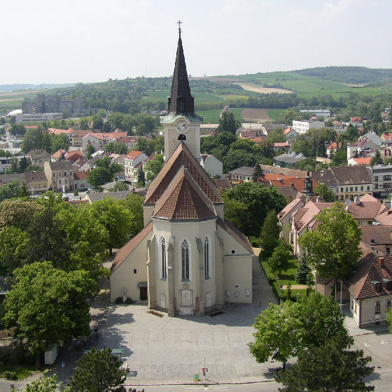
Grabern (Grabern)
- municipality in Austria
Grabern, nestled in the picturesque landscapes of Lower Austria, offers a variety of hiking options for enthusiasts looking to explore its natural beauty. While it may not be as well-known as some of the larger hiking regions, the area around Grabern provides charming trails that showcase the rolling hills, vineyards, and scenic views characteristic of this part of Austria.
Key Points for Hiking in Grabern:
-
Trail Variety: Expect a mix of easy to moderate trails suitable for families, casual hikers, and more experienced adventurers. Many trails wind through beautiful countryside and can be combined for longer treks.
-
Scenic Views: The region's landscape includes forests, fields, and vineyards, offering fantastic views and plenty of opportunities for photography. The rolling hills and changing seasonal colors make hiking here particularly rewarding.
-
Wildlife and Nature: As you hike, keep an eye out for local wildlife, including birds and small mammals, and enjoy the rich plant life. The area is relatively quiet, providing a peaceful experience in nature.
-
Local Culture: Take the opportunity to explore the small villages and local wineries along the way. Many trails may lead you through or near vineyards, allowing for a taste of local wine at the end of your hike.
-
Maps and Navigation: It's advisable to carry a detailed map of the area or use a hiking app with GPS capabilities. Marked trails can sometimes be sparse, so it’s best to be prepared.
-
Weather Considerations: Always check the weather forecast before heading out. The climate in Lower Austria can change rapidly, especially in the spring and fall.
-
Gear: Wear sturdy hiking boots and dress in layers suitable for the changing weather conditions. Don't forget to bring water, snacks, and a first aid kit.
-
Accessibility: Grabern’s trails can typically be accessed from various points within the village and surrounding areas, making it easy to start your hike without extensive travel.
-
Community Events: Look out for local hiking events or guided tours, which can enhance your experience and provide insights into the region’s ecology and culture.
Overall, hiking in Grabern is a charming way to enjoy the stunning nature of Lower Austria while also experiencing the local culture. Whether you're a novice hiker or a seasoned trekk enthusiast, Grabern has something to offer everyone.
- Country:

- Postal Code: 2020
- Local Dialing Code: 02952
- Licence Plate Code: HL
- Coordinates: 48° 36' 51" N, 16° 1' 11" E


- GPS tracks (wikiloc): [Link]
- AboveSeaLevel: 251 м m
- Area: 30.94 sq km
- Population: 1642
- Web site: http://www.gemeinde-grabern.at
- Wikipedia en: wiki(en)
- Wikipedia: wiki(de)
- Wikidata storage: Wikidata: Q699671
- Wikipedia Commons Category: [Link]
- Freebase ID: [/m/02qx6hk]
- GeoNames ID: Alt: [7871763]
- VIAF ID: Alt: [239667255]
- archINFORM location ID: [11044]
- Austrian municipality key: [31009]
Shares border with regions:

Hollabrunn
- municipality in Austria
Hollabrunn is a town located in Lower Austria, surrounded by beautiful landscapes, which makes it a great place for hiking enthusiasts. The region offers a variety of trails suitable for different skill levels, ranging from leisurely walks to more challenging hikes....
- Country:

- Postal Code: 2020
- Local Dialing Code: 02952
- Licence Plate Code: HL
- Coordinates: 48° 34' 0" N, 16° 5' 0" E


- GPS tracks (wikiloc): [Link]
- AboveSeaLevel: 236 м m
- Area: 152.38 sq km
- Population: 11681
- Web site: [Link]

Guntersdorf
- municipality in Austria
Guntersdorf is a charming village located in Austria, nestled in the scenic landscape of Lower Austria. While Guntersdorf itself is small, the surrounding area offers beautiful hiking opportunities that allow you to explore nature, enjoy the countryside, and soak in the tranquil atmosphere....
- Country:

- Postal Code: 2042
- Local Dialing Code: 02951
- Licence Plate Code: HL
- Coordinates: 48° 39' 0" N, 16° 3' 0" E


- GPS tracks (wikiloc): [Link]
- AboveSeaLevel: 246 м m
- Area: 28.41 sq km
- Population: 1145
- Web site: [Link]

Sitzendorf an der Schmida
- municipality in Austria
 Hiking in Sitzendorf an der Schmida
Sitzendorf an der Schmida is a picturesque village located in the Lower Austria region of Austria. The surrounding countryside offers a delightful range of hiking opportunities, making it a great destination for outdoor enthusiasts....
- Country:

- Postal Code: 3714
- Local Dialing Code: 02959
- Licence Plate Code: HL
- Coordinates: 48° 35' 59" N, 15° 56' 24" E


- GPS tracks (wikiloc): [Link]
- AboveSeaLevel: 244 м m
- Area: 61.85 sq km
- Population: 2162
- Web site: [Link]

Wullersdorf
- municipality in Austria
Wullersdorf, located in Austria, is a charming destination for hiking enthusiasts. The region is characterized by its picturesque landscapes, rolling hills, and a mix of rural and forested areas, making it an excellent spot for outdoor activities....
- Country:

- Postal Code: 2041
- Local Dialing Code: 02951
- Licence Plate Code: HL
- Coordinates: 48° 38' 0" N, 16° 6' 0" E


- GPS tracks (wikiloc): [Link]
- AboveSeaLevel: 248 м m
- Area: 63.89 sq km
- Population: 2385
- Web site: [Link]