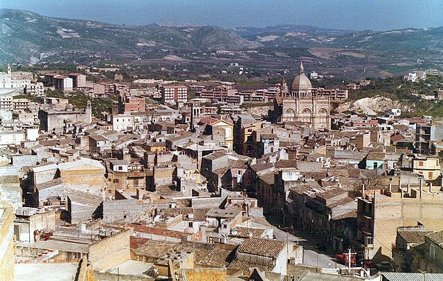
Grotte (Grotte)
.svg)
- Italian comune
 Hiking in Grotte
Hiking in Grotte, Sicily, offers a unique blend of natural beauty, historical sites, and Mediterranean charm. Grotte is a small town located in the Province of Agrigento, surrounded by stunning landscapes and agricultural land. Here are some highlights and tips for hiking in this area:
1.
- Natural Parks: The nearby Parco della Valle dei Templi (Valley of the Temples) is not only a UNESCO World Heritage site but also offers several trails around archaeological areas with dramatic views of ancient ruins and olive groves.
- Forests and Hills: The Monte Cammarata Regional Park to the north of Grotte features a variety of hiking trails that cater to different skill levels, allowing you to explore limestone cliffs, dense forests, and panoramic viewpoints.
2.
- Hikes in this region often reward you with breathtaking views of the surrounding valleys, mountains, and even the coastline in the distance. Keep your camera ready for stunning sunsets and picturesque landscapes.
3.
- As you hike, you’ll likely pass through vineyards and orchards, where you can enjoy the local agricultural produce. Be sure to sample some local wines or olive oil.
4.
- Grotte itself has historical significance with charming streets, churches, and local markets. Incorporating visits to historical sites along your hikes can enhance the experience.
5.
- The area is home to diverse flora and fauna, including various bird species and endemic plants. Nature enthusiasts should keep an eye out for unique wildlife during their hikes.
6.
- The best time for hiking in Grotte is during the spring (April to June) and fall (September to October) when the weather is milder and the trails are less crowded. Summer can be hot, so early morning hikes are advisable.
7.
- Always carry enough water, wear good hiking shoes, and check the weather conditions before heading out. Some trails may require moderate physical fitness due to elevation changes, so choose trails that suit your skill level.
8.
- Hiring a local guide can enhance your experience significantly. They can provide insights into the natural and cultural history of the area that you might miss on your own.
Conclusion
Hiking in Grotte, Sicily, offers not just physical activity but also an opportunity to immerse yourself in the local culture and breathtaking scenery. Whether you're seeking a leisurely stroll or a challenging trek, Grotte and its surroundings have something to offer every hiking enthusiast.
- Country:

- Postal Code: 92020
- Local Dialing Code: 0922
- Licence Plate Code: AG
- Coordinates: 37° 24' 21" N, 13° 42' 4" E


- GPS tracks (wikiloc): [Link]
- AboveSeaLevel: 516 м m
- Area: 23.98 sq km
- Population: 5600
- Web site: http://www.comunedigrotte.gov.it
- Wikipedia en: wiki(en)
- Wikipedia: wiki(it)
- Wikidata storage: Wikidata: Q431568
- Wikipedia Commons Category: [Link]
- Freebase ID: [/m/0gqg4h]
- GeoNames ID: Alt: [6540061]
- VIAF ID: Alt: [154974668]
- OSM relation ID: [39233]
- GND ID: Alt: [4693470-4]
- Library of Congress authority ID: Alt: [n2004037773]
- UN/LOCODE: [ITGGT]
- ISTAT ID: 084018
- Italian cadastre code: E209
Shares border with regions:
Milena, Sicily
- Italian comune
Hiking in Milena, Sicily
Hiking in Milena, a small town in the province of Caltanissetta in Sicily, offers a unique blend of natural beauty, cultural heritage, and a chance to experience the Sicilian countryside. Here are some key points about hiking in this area:...
- Country:
- Postal Code: 93010
- Local Dialing Code: 0934
- Licence Plate Code: CL
- Coordinates: 37° 28' 0" N, 13° 44' 0" E
- GPS tracks (wikiloc): [Link]
- AboveSeaLevel: 423 м m
- Area: 24.63 sq km
- Population: 2953
- Web site: [Link]


Aragona
- Italian comune
Hiking in Aragona
Aragona, located in Sicily, Italy, offers a unique hiking experience with its rich natural landscape, history, and culture. Here are some key points to consider if you plan to hike in the region:...
- Country:
- Postal Code: 92021
- Local Dialing Code: 0922
- Licence Plate Code: AG
- Coordinates: 37° 24' 27" N, 13° 37' 8" E
- GPS tracks (wikiloc): [Link]
- AboveSeaLevel: 400 м m
- Area: 74.7 sq km
- Population: 9409
- Web site: [Link]


Comitini
- Italian comune
Hiking in Comitini
Comitini, located in the heart of Sicily, offers a unique hiking experience characterized by its beautiful landscapes, historical sites, and natural beauty. Here are some aspects to consider when hiking in this area:...
- Country:
- Postal Code: 92020
- Local Dialing Code: 0922
- Licence Plate Code: AG
- Coordinates: 37° 24' 32" N, 13° 38' 38" E
- GPS tracks (wikiloc): [Link]
- AboveSeaLevel: 350 м m
- Area: 21.89 sq km
- Population: 961
- Web site: [Link]

Favara
- Italian comune
Hiking in Favara
Favara, a town in Sicily, provides some excellent hiking opportunities, allowing you to explore the beautiful Sicilian landscape and its rich cultural heritage. Here are some key points about hiking in and around Favara:...
- Country:
- Postal Code: 92026
- Local Dialing Code: 0922
- Licence Plate Code: AG
- Coordinates: 37° 19' 7" N, 13° 39' 47" E
- GPS tracks (wikiloc): [Link]
- AboveSeaLevel: 338 м m
- Area: 81.88 sq km
- Population: 32299
- Web site: [Link]


Racalmuto
- Italian comune
Hiking in Racalmuto
Racalmuto, located in Sicily, Italy, is surrounded by beautiful landscapes that are ideal for hiking enthusiasts. The terrain in and around Racalmuto features a mix of rolling hills, vineyards, and orchards, providing a variety of trails that cater to different skill levels....
- Country:
- Postal Code: 92020
- Local Dialing Code: 0922
- Licence Plate Code: AG
- Coordinates: 37° 24' 30" N, 13° 44' 5" E
- GPS tracks (wikiloc): [Link]
- AboveSeaLevel: 455 м m
- Area: 68.1 sq km
- Population: 8155
- Web site: [Link]


Campofranco
- Italian comune
Hiking in Campofranco
Campofranco, located in the province of Caltanissetta in Sicily, Italy, offers a unique and beautiful hiking experience. The region is known for its diverse landscapes, which include rolling hills, agricultural fields, and stunning views of the surrounding countryside. While it may not be as famous as some other hiking destinations in Sicily, it has its own charm and appeal for those looking to explore less-traveled paths....
- Country:
- Postal Code: 93010
- Local Dialing Code: 0934
- Licence Plate Code: CL
- Coordinates: 37° 31' 0" N, 13° 42' 0" E
- GPS tracks (wikiloc): [Link]
- AboveSeaLevel: 350 м m
- Area: 36.11 sq km
- Population: 2992
- Web site: [Link]