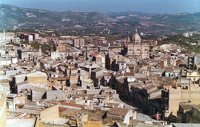
Racalmuto (Racalmuto)
.svg)
- Italian comune
 Hiking in Racalmuto
Racalmuto, located in Sicily, Italy, is surrounded by beautiful landscapes that are ideal for hiking enthusiasts. The terrain in and around Racalmuto features a mix of rolling hills, vineyards, and orchards, providing a variety of trails that cater to different skill levels.
Hiking Areas and Trails:
-
Monte Cavallo: This is one of the most popular hiking destinations near Racalmuto. The trail to the summit offers stunning panoramic views of the surrounding countryside. The terrain can vary, so it’s a good idea to ensure you have the right footwear and gear.
-
Natural Reserves: The area around Racalmuto is close to several nature reserves, including the Vallone di Naro and the nearby Sicani Mountains. These areas are great for hiking, providing a chance to experience diverse flora and fauna.
-
Historical Trails: Some trails in the vicinity connect to historical sites, such as old ruins and ancient pathways. Exploring these areas can add an educational aspect to your hiking experience.
-
Vineyard Trails: Given the local wine production, you may find trails that wind through vineyards and olive groves. These can be idyllic, especially during harvest season.
Tips for Hiking in Racalmuto:
-
Weather: Be mindful of the weather, as it can change quickly. Summers can be hot, so early morning or late afternoon hikes are ideal. Spring and fall offer more comfortable temperatures.
-
Safety: Always let someone know your hiking plans and carry enough water. It’s also wise to have a map or a mobile device with GPS capabilities.
-
Local Guidance: Consider connecting with local hiking groups or guides who can provide insights into the best trails and hidden gems.
-
Respect Nature: Practice Leave No Trace principles to help maintain the beauty of the area for future hikers.
With its rich landscapes and cultural heritage, hiking in Racalmuto can be an enriching experience. Enjoy the trails!
- Country:

- Postal Code: 92020
- Local Dialing Code: 0922
- Licence Plate Code: AG
- Coordinates: 37° 24' 30" N, 13° 44' 5" E


- GPS tracks (wikiloc): [Link]
- AboveSeaLevel: 455 м m
- Area: 68.1 sq km
- Population: 8155
- Web site: http://www.comune.racalmuto.ag.it
- Wikipedia en: wiki(en)
- Wikipedia: wiki(it)
- Wikidata storage: Wikidata: Q432337
- Wikipedia Commons Category: [Link]
- Freebase ID: [/m/0gqg91]
- GeoNames ID: Alt: [6537781]
- VIAF ID: Alt: [139492141]
- OSM relation ID: [39234]
- GND ID: Alt: [4473599-6]
- Library of Congress authority ID: Alt: [n86098120]
- UN/LOCODE: [ITRCM]
- ISTAT ID: 084029
- Italian cadastre code: H148
Shares border with regions:
Milena, Sicily
- Italian comune
Hiking in Milena, Sicily
Hiking in Milena, a small town in the province of Caltanissetta in Sicily, offers a unique blend of natural beauty, cultural heritage, and a chance to experience the Sicilian countryside. Here are some key points about hiking in this area:...
- Country:
- Postal Code: 93010
- Local Dialing Code: 0934
- Licence Plate Code: CL
- Coordinates: 37° 28' 0" N, 13° 44' 0" E
- GPS tracks (wikiloc): [Link]
- AboveSeaLevel: 423 м m
- Area: 24.63 sq km
- Population: 2953
- Web site: [Link]


Castrofilippo
- Italian comune
Hiking in Castrofilippo
Castrofilippo, a charming municipality located in the province of Agrigento, Sicily, offers various opportunities for hiking enthusiasts to explore the beautiful Sicilian landscape. Here are some highlights and tips for hiking in the area:...
- Country:
- Postal Code: 92020
- Local Dialing Code: 0922
- Licence Plate Code: AG
- Coordinates: 37° 21' 0" N, 13° 45' 4" E
- GPS tracks (wikiloc): [Link]
- AboveSeaLevel: 470 м m
- Area: 18.08 sq km
- Population: 2912
- Web site: [Link]


Canicattì
- Italian comune
Hiking in Canicattì
Canicattì, located in the southern part of Sicily, Italy, offers a unique landscape for hikers, with its rolling hills, rocky terrain, and rich cultural history. While it may not be as famous for hiking as some of the larger Sicilian destinations like Mount Etna or the Madonie Mountains, it does provide opportunities for outdoor enthusiasts looking for a more off-the-beaten-path experience....
- Country:
- Postal Code: 92024
- Local Dialing Code: 0922
- Licence Plate Code: AG
- Coordinates: 37° 21' 36" N, 13° 51' 4" E
- GPS tracks (wikiloc): [Link]
- AboveSeaLevel: 465 м m
- Area: 91.86 sq km
- Population: 35722
- Web site: [Link]

Favara
- Italian comune
Hiking in Favara
Favara, a town in Sicily, provides some excellent hiking opportunities, allowing you to explore the beautiful Sicilian landscape and its rich cultural heritage. Here are some key points about hiking in and around Favara:...
- Country:
- Postal Code: 92026
- Local Dialing Code: 0922
- Licence Plate Code: AG
- Coordinates: 37° 19' 7" N, 13° 39' 47" E
- GPS tracks (wikiloc): [Link]
- AboveSeaLevel: 338 м m
- Area: 81.88 sq km
- Population: 32299
- Web site: [Link]


Grotte
- Italian comune
Hiking in Grotte
Hiking in Grotte, Sicily, offers a unique blend of natural beauty, historical sites, and Mediterranean charm. Grotte is a small town located in the Province of Agrigento, surrounded by stunning landscapes and agricultural land. Here are some highlights and tips for hiking in this area:...
- Country:
- Postal Code: 92020
- Local Dialing Code: 0922
- Licence Plate Code: AG
- Coordinates: 37° 24' 21" N, 13° 42' 4" E
- GPS tracks (wikiloc): [Link]
- AboveSeaLevel: 516 м m
- Area: 23.98 sq km
- Population: 5600
- Web site: [Link]
Bompensiere
- Italian comune
Hiking in Bompensiere
Bompensiere is a small town located in Sicily, Italy, surrounded by beautiful natural landscapes that are perfect for hiking enthusiasts. The area features various trails that range in difficulty, catering to both novice and experienced hikers....
- Country:
- Postal Code: 93010
- Local Dialing Code: 0934
- Licence Plate Code: CL
- Coordinates: 37° 28' 0" N, 13° 47' 0" E
- GPS tracks (wikiloc): [Link]
- AboveSeaLevel: 283 м m
- Area: 19.95 sq km
- Population: 553
- Web site: [Link]


Montedoro
- Italian comune
Hiking in Montedoro
Montedoro, located in Sicily, Italy, offers a range of hiking opportunities that cater to various skill levels and preferences. The landscape is characterized by rolling hills, olive groves, and scenic views of the surrounding countryside, providing a beautiful backdrop for outdoor activities....
- Country:
- Postal Code: 93010
- Local Dialing Code: 0934
- Licence Plate Code: CL
- Coordinates: 37° 27' 16" N, 13° 49' 1" E
- GPS tracks (wikiloc): [Link]
- AboveSeaLevel: 450 м m
- Area: 14.53 sq km
- Population: 1557
- Web site: [Link]