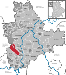
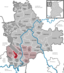
Hafenlohr (Hafenlohr)
- municipality of Germany
Hafenlohr, located in the Bavarian region of Germany, offers some beautiful hiking opportunities that showcase the natural beauty and scenic landscapes of the area. Here are some key points to consider when planning a hike in Hafenlohr:
Trails and Terrain
-
Diverse Trails: Hafenlohr features various trails suitable for different skill levels, from easy walks to more challenging hikes. The terrain often includes wooded areas, open fields, and scenic views of local hills and valleys.
-
Good Signage: Many hiking paths are well-marked, making it easier for hikers to navigate the trails. Look for the familiar yellow hiking signs that indicate directions and distances.
-
Hafenlohr Valley: The Hafenlohr Valley itself is one of the main attractions, offering picturesque views along the river. You can enjoy nature while traversing the riverbank or explore the surrounding hills.
Nature and Wildlife
- Rich Biodiversity: The region is home to a variety of flora and fauna, making it a great spot for nature lovers and bird watchers.
- Scenic Smells: Expect to experience the fresh scents of pine and wildflowers, especially in the spring and summer months.
Nearby Attractions
- Historical Sites: Consider incorporating visits to nearby villages or historical sites, as the area is rich in Bavarian culture and history.
- Local Cuisine: After a hike, enjoy traditional Bavarian food at local restaurants or inns, which can add to the overall experience.
Best Times to Hike
- Spring and Fall: These seasons are particularly pleasant for hiking, with moderate temperatures and stunning scenery, especially during the fall foliage season.
- Summer: Can be warmer, so ensure you hydrate and wear appropriate sun protection.
Safety Tips
- Dress Appropriately: Wear comfortable and sturdy hiking boots, dress in layers, and bring rain gear if the weather forecast indicates possible rain.
- Stay Hydrated: Always carry enough water, especially on warmer days.
- Follow Trail Guidelines: Stick to marked paths to protect the local environment and avoid getting lost.
Local Hiking Groups or Events
- If you're interested in meeting fellow hikers or exploring with groups, look for local hiking clubs or events in Hafenlohr, as these can enhance your hiking experience.
Conclusion
Hiking in Hafenlohr offers an excellent way to experience the natural beauty of Bavaria, whether you're an experienced hiker or a beginner. With its diverse trails and rich landscapes, it’s a wonderful escape for nature enthusiasts. Make sure to plan ahead and check the local weather before heading out!
- Country:

- Postal Code: 97840
- Local Dialing Code: 09391
- Licence Plate Code: MSP
- Coordinates: 49° 52' 0" N, 9° 36' 0" E


- GPS tracks (wikiloc): [Link]
- AboveSeaLevel: 170 м m
- Area: 11.33 sq km
- Population: 1867
- Web site: http://www.hafenlohr.de
- Wikipedia en: wiki(en)
- Wikipedia: wiki(de)
- Wikidata storage: Wikidata: Q508592
- Wikipedia Commons Category: [Link]
- Freebase ID: [/m/02q4hyc]
- GeoNames ID: Alt: [2912753]
- OSM relation ID: [337249]
- GND ID: Alt: [4232827-5]
- Bavarikon ID: [ODB_A00000435]
- German municipality key: 09677135
- German regional key: 096775621135
Includes regions:
Hafenlohr
- Ortsteil of Hafenlohr
Hafenlohr, located in Bavaria, Germany, is a picturesque destination for hiking enthusiasts. Nestled near the Spessart Forest, the area offers a range of trails that cater to various skill levels, from beginners to experienced hikers....
- Country:

- Postal Code: 97840
- Local Dialing Code: 09391
- Coordinates: 49° 52' 12" N, 9° 36' 7" E


- GPS tracks (wikiloc): [Link]
- AboveSeaLevel: 168 м m
Windheim
- Ortsteil of Hafenlohr
Windheim in Hafenlohr, located in Bavaria, Germany, is a great destination for hikers looking to explore beautiful natural landscapes. The region is characterized by its rolling hills, dense forests, and picturesque views of the surrounding countryside....
- Country:

- Coordinates: 49° 52' 54" N, 9° 34' 54" E


- GPS tracks (wikiloc): [Link]
- AboveSeaLevel: 170 м m
Shares border with regions:
Forst Lohrerstraße
- unincorporated area in Germany
Forst Lohrerstraße is located in the beautiful region of Bavaria, Germany. While it may not be as widely known as some of the larger national parks or hiking regions, it offers a scenic environment for outdoor enthusiasts. Here are some highlights and tips for hiking in and around Forst Lohrerstraße:...
- Country:

- Coordinates: 49° 58' 17" N, 9° 29' 4" E


- GPS tracks (wikiloc): [Link]


Fürstlich Löwensteinscher Park
- unincorporated area in Germany
 Hiking in Fürstlich Löwensteinscher Park
Fürstlich Löwensteinscher Park, located near the town of Weikersheim in Germany, is a beautiful park that offers a serene environment for hiking and outdoor activities. The park is known for its picturesque landscapes, well-maintained paths, and historical significance....
- Country:

- Coordinates: 49° 54' 15" N, 9° 29' 49" E


- GPS tracks (wikiloc): [Link]


Esselbach
- municipality of Germany
Esselbach is a charming area in Bavaria, Germany, that offers a variety of hiking opportunities amidst picturesque landscapes of lush forests, rolling hills, and the beautiful Esselbach River. Here are some highlights and tips for hiking in the Esselbach region:...
- Country:

- Postal Code: 97839
- Local Dialing Code: 09394
- Licence Plate Code: MSP
- Coordinates: 49° 51' 19" N, 9° 31' 33" E


- GPS tracks (wikiloc): [Link]
- AboveSeaLevel: 308 м m
- Area: 10.33 sq km
- Population: 1747
- Web site: [Link]


Marktheidenfeld
- human settlement in Germany
Marktheidenfeld is a charming town in Bavaria, Germany, located along the banks of the Main River. The surrounding area offers some beautiful hiking opportunities, particularly due to its picturesque landscapes and scenic routes. Here’s a brief overview of what you can expect when hiking in and around Marktheidenfeld:...
- Country:

- Postal Code: 97828
- Local Dialing Code: 0 93 91
- Coordinates: 49° 51' 0" N, 9° 36' 0" E


- GPS tracks (wikiloc): [Link]
- AboveSeaLevel: 162 м m
- Area: 37.54 sq km
- Population: 10901
- Web site: [Link]


Rothenfels
- town in Bavaria, Germany
Rothenfels is a picturesque village located in Bavaria, Germany, nestled within the beautiful landscape of the Fränkische Schweiz (Franconian Switzerland) region. This area is known for its dramatic limestone cliffs, dense forests, and charming medieval architecture....
- Country:

- Postal Code: 97851
- Local Dialing Code: 09393
- Licence Plate Code: MSP
- Coordinates: 49° 53' 0" N, 9° 35' 0" E


- GPS tracks (wikiloc): [Link]
- AboveSeaLevel: 154 м m
- Area: 12.07 sq km
- Population: 1011
- Web site: [Link]
