Haussimont (Haussimont)

- commune in Marne, France
- Country:

- Postal Code: 51320
- Coordinates: 48° 44' 55" N, 4° 9' 59" E


- GPS tracks (wikiloc): [Link]
- Area: 17.63 sq km
- Population: 141
- Wikipedia en: wiki(en)
- Wikipedia: wiki(fr)
- Wikidata storage: Wikidata: Q1218857
- Wikipedia Commons Category: [Link]
- Freebase ID: [/m/03qd73d]
- GeoNames ID: Alt: [6435839]
- SIREN number: [215102666]
- BnF ID: [15262890x]
- INSEE municipality code: 51285
Shares border with regions:


Bussy-Lettrée
- commune in Marne, France
- Country:
- Postal Code: 51320
- Coordinates: 48° 48' 18" N, 4° 15' 37" E
- GPS tracks (wikiloc): [Link]
- Area: 33.48 sq km
- Population: 348

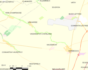
Vassimont-et-Chapelaine
- commune in Marne, France
- Country:
- Postal Code: 51320
- Coordinates: 48° 45' 51" N, 4° 8' 40" E
- GPS tracks (wikiloc): [Link]
- Area: 21.73 sq km
- Population: 59


Sommesous
- commune in Marne, France
- Country:
- Postal Code: 51320
- Coordinates: 48° 44' 18" N, 4° 11' 48" E
- GPS tracks (wikiloc): [Link]
- Area: 37.04 sq km
- Population: 526
Montépreux
- commune in Marne, France
- Country:
- Postal Code: 51320
- Coordinates: 48° 42' 46" N, 4° 8' 17" E
- GPS tracks (wikiloc): [Link]
- Area: 15.41 sq km
- Population: 42