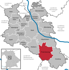
Heideck (Heideck)
- human settlement in Germany
Heideck, located in Bavaria, Germany, offers some enjoyable hiking opportunities that are popular among outdoor enthusiasts. The area is characterized by its beautiful natural landscapes, rolling hills, and lush forests. Here are some highlights of hiking in and around Heideck:
-
Scenic Trails: There are several well-marked hiking trails in the region that cater to various skill levels. These trails often lead through idyllic countryside, offering views of meadows, woodlands, and local wildlife.
-
Historical Sites: While hiking in Heideck, you might encounter historical landmarks, including castles and churches that add cultural depth to your outdoor experience.
-
Nature Parks: The surrounding areas may include nature parks or protected landscapes, providing a chance to observe diverse flora and fauna. Keep an eye out for local wildlife along the trails.
-
Accessibility: Many trails are easily accessible, making them suitable for families and hikers of all ages. It's always advisable to check local trail maps and conditions before heading out.
-
Local Tips: When hiking in Heideck, consider stopping by local information centers or tourist offices for maps and recommendations on specific trails and current conditions. Additionally, it's important to pack essentials like water, snacks, a first-aid kit, and proper footwear.
-
Seasonal Considerations: Depending on the time of year, the trails can offer different experiences. Spring and summer provide lush greenery and blooming flowers, while autumn offers beautiful fall colors.
Always ensure you respect nature and stay on marked trails to preserve the environment. Enjoy your hike in Heideck, and make sure to take in the stunning Bavarian landscape!
- Country:

- Postal Code: 91180
- Local Dialing Code: 09177
- Licence Plate Code: RH
- Coordinates: 49° 7' 0" N, 11° 7' 0" E


- GPS tracks (wikiloc): [Link]
- AboveSeaLevel: 407 м m
- Area: 58.64 sq km
- Population: 4688
- Web site: http://www.heideck.de
- Wikipedia en: wiki(en)
- Wikipedia: wiki(de)
- Wikidata storage: Wikidata: Q502445
- Wikipedia Commons Category: [Link]
- Freebase ID: [/m/0fdl9t]
- GeoNames ID: Alt: [2907983]
- VIAF ID: Alt: [125482168]
- OSM relation ID: [158555]
- GND ID: Alt: [4023991-3]
- archINFORM location ID: [42199]
- Library of Congress authority ID: Alt: [n79144433]
- Historical Gazetteer (GOV) ID: [HEIECKJN59NC]
- Bavarikon ID: [ODB_A00000185]
- German municipality key: 09576126
Shares border with regions:


Pleinfeld
- municipality in Germany
Pleinfeld, located in the state of Bavaria, Germany, is a charming destination for hiking enthusiasts. Nestled near the beautiful Franconian Lake District, it offers a range of hiking trails that cater to various skill levels and preferences. Here are some highlights and tips for hiking in Pleinfeld:...
- Country:

- Postal Code: 91785
- Local Dialing Code: 09177; 09144
- Licence Plate Code: WUG
- Coordinates: 49° 6' 0" N, 10° 58' 0" E


- GPS tracks (wikiloc): [Link]
- AboveSeaLevel: 382 м m
- Area: 71.35 sq km
- Population: 7443
- Web site: [Link]


Thalmässing
- municipality in the district of Roth, in Bavaria, Germany
Thalmässing is a charming municipality located in Bavaria, Germany, offering a variety of hiking opportunities that cater to different skill levels and interests. The area is characterized by its picturesque landscapes, wooded hills, fertile fields, and quaint villages, making it a great destination for nature lovers and outdoor enthusiasts....
- Country:

- Postal Code: 91177
- Local Dialing Code: 09173
- Licence Plate Code: RH
- Coordinates: 49° 5' 0" N, 11° 13' 0" E


- GPS tracks (wikiloc): [Link]
- AboveSeaLevel: 418 м m
- Area: 80.57 sq km
- Population: 5010
- Web site: [Link]


Ettenstatt
- municipality of Germany
Ettenstatt is a charming village located in the Altmühl Valley in Bavaria, Germany. This region is well-known for its beautiful landscapes, rich history, and diverse outdoor activities, including hiking....
- Country:

- Postal Code: 91796
- Local Dialing Code: 09148
- Licence Plate Code: WUG
- Coordinates: 49° 4' 59" N, 11° 3' 0" E


- GPS tracks (wikiloc): [Link]
- AboveSeaLevel: 440 м m
- Area: 15.84 sq km
- Population: 846
- Web site: [Link]


Bergen
- municipality in the Weißenburg-Gunzenhausen district, in Bavaria, Germany
Bergen, located in the Middle Franconia region of Germany, offers a variety of hiking opportunities for all levels of experience. The picturesque landscape is characterized by rolling hills, wooded areas, and charming rural vistas, making it an ideal spot for hiking enthusiasts....
- Country:

- Postal Code: 91790
- Local Dialing Code: 09148; 09147
- Licence Plate Code: WUG
- Coordinates: 49° 5' 0" N, 11° 7' 0" E


- GPS tracks (wikiloc): [Link]
- AboveSeaLevel: 540 м m
- Area: 19.91 sq km
- Population: 1082
- Web site: [Link]


Georgensgmünd
- municipality of Germany
Georgensgmünd is a lovely village located in Bavaria, Germany, known for its picturesque landscapes and natural beauty, making it a great destination for hiking enthusiasts. The area offers several trails that cater to various skill levels, allowing hikers to enjoy the serene countryside and forested areas....
- Country:

- Postal Code: 91166
- Local Dialing Code: 09172
- Licence Plate Code: RH
- Coordinates: 49° 11' 0" N, 11° 0' 0" E


- GPS tracks (wikiloc): [Link]
- AboveSeaLevel: 358 м m
- Area: 46.96 sq km
- Population: 5167
- Web site: [Link]

