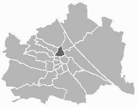
Hernals (Hernals)

- 17. district of Vienna
 Hiking in Hernals
Hernals is a district in Vienna, Austria, known for its charming neighborhoods and proximity to nature. While Hernals itself is primarily urban, the nearby areas, especially the Vienna Woods (Wienerwald), offer excellent hiking opportunities.
Hiking in Hernals and Surrounding Areas:
-
Nearby Trails:
- Hiking in the Vienna Woods: Just a short distance from Hernals, this expansive forest area has numerous trails suitable for all levels of hikers. You can find routes that lead you through picturesque scenery, including hills, forests, and vineyards.
- Kahlenberg: A popular hiking destination near Hernals, Kahlenberg has trails that offer stunning views over Vienna. The ascent can be challenging, but it’s rewarding with its panoramic vistas.
-
Recommended Hikes:
- Hernals to Steinhof: A scenic, moderate hike from Hernals to the famous Otto Wagner Church (Steinhof Church) offers a blend of nature and architectural beauty.
- Pötzleinsdorfer Schlosspark: Starting from Hernals, you can enjoy a leisurely hike through this beautiful park, which is perfect for families and casual walkers.
-
Seasonal Considerations:
- Spring and autumn are ideal for hiking due to mild weather and beautiful foliage. Summer can be hot, so plan for early morning hikes to avoid the heat.
- Winter hiking is also possible, typically requiring proper footwear and clothing.
-
Preparation Tips:
- Footwear: Wear sturdy, comfortable hiking shoes or boots.
- Gear: Bring water, snacks, a map of the trails, and a first-aid kit.
- Weather: Check the weather forecast before you head out, as conditions can change quickly in the woods.
-
Local Amenities:
- You can find several local cafes and restaurants in Hernals where you can rest and refuel after your hike.
Safety Tips:
- Always inform someone about your hiking plans.
- Stay on designated trails to protect the local flora and fauna.
- Be aware of wildlife and follow local safety guidelines.
Hiking in and around Hernals can be a refreshing escape from urban life, providing a blend of natural beauty, wildlife, and cultural experiences. Enjoy your hikes!
- Country:

- Postal Code: 1170
- Licence Plate Code: W
- Coordinates: 48° 13' 57" N, 16° 16' 46" E


- GPS tracks (wikiloc): [Link]
- AboveSeaLevel: 224 м m
- Area: 11.35 sq km
- Web site: http://www.wien.gv.at/bezirke/hernals/
- Wikipedia en: wiki(en)
- Wikipedia: wiki(de)
- Wikidata storage: Wikidata: Q262808
- Wikipedia Commons Gallery: [Link]
- Wikipedia Commons Category: [Link]
- Freebase ID: [/m/06mln1]
- GeoNames ID: Alt: [2776486]
- VIAF ID: Alt: [2774149489091193810000]
- GND ID: Alt: [4079289-4]
- archINFORM location ID: [3697]
- Library of Congress authority ID: Alt: [nr90008510]
- MusicBrainz area ID: [7ca48002-c4b7-4db5-ab0f-2908ecd7a781]
- TGN ID: [1004647]
- Austrian municipality key: [91701]
- Pleiades ID: [128408]
Shares border with regions:
Josefstadt
- 8. district of Vienna
Hiking in Josefstadt
Josefstadt is a district in Vienna, Austria, known more for its urban characteristics rather than hiking trails. However, its proximity to the Vienna Woods (Wienerwald) offers great opportunities for hiking enthusiasts. While the district itself may not have dedicated hiking trails, you can easily access various trails in the nearby areas....
- Country:
- Postal Code: 1080
- Licence Plate Code: W
- Coordinates: 48° 12' 39" N, 16° 20' 53" E
- GPS tracks (wikiloc): [Link]
- AboveSeaLevel: 209 м m
- Area: 1.08 sq km
- Web site: [Link]

Alsergrund
- 9. district of Vienna
Hiking in Alsergrund
Alsergrund is one of the 23 districts of Vienna, Austria, and while it's not primarily known for hiking in the traditional sense of wilderness trails, it does offer some enjoyable walking opportunities, particularly for urban hiking or strolling through green spaces....
- Country:
- Postal Code: 1090
- Licence Plate Code: W
- Coordinates: 48° 13' 31" N, 16° 21' 25" E
- GPS tracks (wikiloc): [Link]
- AboveSeaLevel: 179 м m
- Area: 2.99 sq km
- Web site: [Link]
Ottakring
- 16. district of Vienna
Hiking in Ottakring
Ottakring is a vibrant district in Vienna, Austria, known for its mix of urban culture and access to nature. While Ottakring is primarily an urban area, it serves as a gateway to various hiking opportunities in the surrounding regions. Here are some highlights and tips for hiking near Ottakring:...
- Country:
- Postal Code: 1160
- Licence Plate Code: W
- Coordinates: 48° 12' 45" N, 16° 18' 38" E
- GPS tracks (wikiloc): [Link]
- AboveSeaLevel: 247 м m
- Area: 8.65 sq km
- Web site: [Link]


Döbling
- 19. district of Vienna
Hiking in Döbling
Döbling is a charming district in Vienna, Austria, known for its scenic landscapes, vineyards, and proximity to the Vienna Woods (Wienerwald). Here are some highlights and tips for hiking in Döbling:...
- Country:
- Postal Code: 1190
- Licence Plate Code: W
- Coordinates: 48° 15' 59" N, 16° 19' 22" E
- GPS tracks (wikiloc): [Link]
- AboveSeaLevel: 247 м m
- Area: 24.9 sq km
- Web site: [Link]
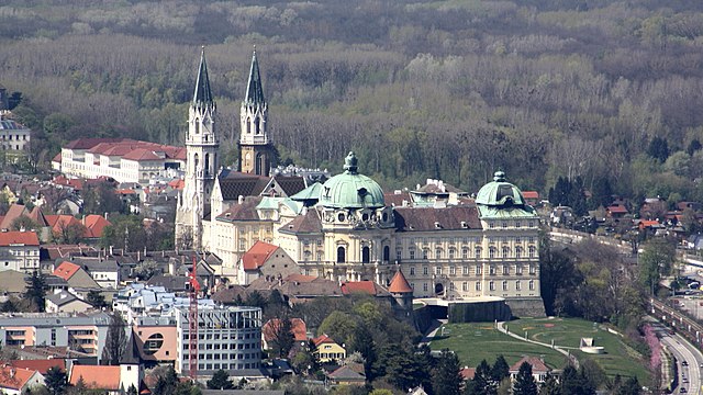

Klosterneuburg
- town in Lower Austria
Hiking in Klosterneuburg
Klosterneuburg, located just north of Vienna, Austria, offers a variety of beautiful hiking trails that cater to different skill levels and preferences. The region is characterized by its picturesque landscapes, historical sites, and proximity to the Vienna Woods (Wienerwald). Here are some highlights and tips for hiking in Klosterneuburg:...
- Country:
- Local Dialing Code: 02243
- Licence Plate Code: WU
- Coordinates: 48° 18' 15" N, 16° 19' 0" E
- GPS tracks (wikiloc): [Link]
- AboveSeaLevel: 192 м m
- Area: 76.2 sq km
- Population: 27058
Penzing
- 14. district of Vienna
Hiking in Penzing
Penzing is a district in the western part of Vienna, Austria, and while it is more urbanized compared to remote hiking destinations, there are still opportunities for outdoor activities and hiking nearby. Here are some options and tips for hiking around Penzing:...
- Country:
- Postal Code: 1140
- Licence Plate Code: W
- Coordinates: 48° 11' 56" N, 16° 18' 40" E
- GPS tracks (wikiloc): [Link]
- AboveSeaLevel: 238 м m
- Area: 33.82 sq km
- Web site: [Link]
Währing
- 18th district of Vienna
Hiking in Währing
Währing is a district in Vienna, Austria, known for its beautiful parks and hills, making it a delightful destination for hiking enthusiasts. Here are some highlights and tips for hiking in Währing:...
- Country:
- Postal Code: 1180
- Licence Plate Code: W
- Coordinates: 48° 13' 59" N, 16° 18' 53" E
- GPS tracks (wikiloc): [Link]
- AboveSeaLevel: 247 м m
- Area: 6.28 sq km
- Web site: [Link]