Herpont (Herpont)

- commune in Marne, France
- Country:

- Postal Code: 51460
- Coordinates: 48° 59' 56" N, 4° 43' 52" E


- GPS tracks (wikiloc): [Link]
- Area: 23 sq km
- Population: 134
- Wikipedia en: wiki(en)
- Wikipedia: wiki(fr)
- Wikidata storage: Wikidata: Q1224196
- Wikipedia Commons Category: [Link]
- Freebase ID: [/m/03qd764]
- GeoNames ID: Alt: [6435844]
- SIREN number: [215102732]
- BnF ID: [15262897b]
- INSEE municipality code: 51292
Shares border with regions:


Poix
- commune in Marne, France
- Country:
- Postal Code: 51460
- Coordinates: 48° 57' 47" N, 4° 37' 30" E
- GPS tracks (wikiloc): [Link]
- Area: 14.72 sq km
- Population: 74
Rapsécourt
- commune in Marne, France
- Country:
- Postal Code: 51330
- Coordinates: 49° 1' 25" N, 4° 47' 41" E
- GPS tracks (wikiloc): [Link]
- Area: 7.23 sq km
- Population: 34

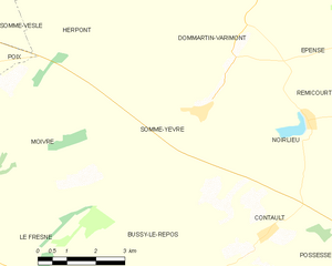
Somme-Yèvre
- commune in Marne, France
- Country:
- Postal Code: 51330
- Coordinates: 48° 57' 4" N, 4° 45' 36" E
- GPS tracks (wikiloc): [Link]
- Area: 21.57 sq km
- Population: 110
Saint-Mard-sur-Auve
- commune in Marne, France
- Country:
- Postal Code: 51800
- Coordinates: 49° 2' 6" N, 4° 43' 36" E
- GPS tracks (wikiloc): [Link]
- Area: 10.1 sq km
- Population: 65
Dommartin-Varimont
- commune in Marne, France
- Country:
- Postal Code: 51330
- Coordinates: 48° 58' 41" N, 4° 46' 56" E
- GPS tracks (wikiloc): [Link]
- AboveSeaLevel: 158 м m
- Area: 23.6 sq km
- Population: 142
Moivre
- commune in Marne, France
- Country:
- Postal Code: 51240
- Coordinates: 48° 55' 27" N, 4° 39' 36" E
- GPS tracks (wikiloc): [Link]
- Area: 21.84 sq km
- Population: 59

Somme-Vesle
- commune in Marne, France
- Country:
- Postal Code: 51460
- Coordinates: 48° 59' 7" N, 4° 35' 30" E
- GPS tracks (wikiloc): [Link]
- Area: 35.31 sq km
- Population: 428

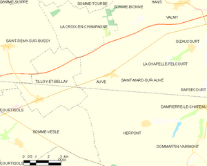
Auve
- commune in Marne, France
- Country:
- Postal Code: 51800
- Coordinates: 49° 2' 2" N, 4° 41' 41" E
- GPS tracks (wikiloc): [Link]
- Area: 23.3 sq km
- Population: 290


Dampierre-le-Château
- commune in Marne, France
- Country:
- Postal Code: 51330
- Coordinates: 49° 0' 35" N, 4° 47' 44" E
- GPS tracks (wikiloc): [Link]
- Area: 11.13 sq km
- Population: 102