Herry (Herry)

- commune in Cher, France
- Country:

- Postal Code: 18140
- Coordinates: 47° 13' 0" N, 2° 57' 14" E


- GPS tracks (wikiloc): [Link]
- Area: 49.87 sq km
- Population: 1013
- Web site: https://herry.fr/
- Wikipedia en: wiki(en)
- Wikipedia: wiki(fr)
- Wikidata storage: Wikidata: Q1422864
- Wikipedia Commons Category: [Link]
- Freebase ID: [/m/096sn5]
- GeoNames ID: Alt: [6428189]
- SIREN number: [211801105]
- BnF ID: [15249456x]
- INSEE municipality code: 18110
Shares border with regions:


Saint-Bouize
- commune in Cher, France
- Country:
- Postal Code: 18300
- Coordinates: 47° 17' 5" N, 2° 53' 6" E
- GPS tracks (wikiloc): [Link]
- Area: 14.97 sq km
- Population: 319


Sancergues
- commune in Cher, France
- Country:
- Postal Code: 18140
- Coordinates: 47° 9' 19" N, 2° 55' 0" E
- GPS tracks (wikiloc): [Link]
- Area: 15.53 sq km
- Population: 679
- Web site: [Link]


Feux
- commune in Cher, France
- Country:
- Postal Code: 18300
- Coordinates: 47° 13' 49" N, 2° 51' 28" E
- GPS tracks (wikiloc): [Link]
- Area: 27.46 sq km
- Population: 338

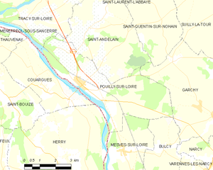
Pouilly-sur-Loire
- commune in Nièvre, France
- Country:
- Postal Code: 58150
- Coordinates: 47° 16' 58" N, 2° 57' 28" E
- GPS tracks (wikiloc): [Link]
- Area: 20.28 sq km
- Population: 1679


Mesves-sur-Loire
- commune in Nièvre, France
- Country:
- Postal Code: 58400
- Coordinates: 47° 14' 36" N, 2° 59' 35" E
- GPS tracks (wikiloc): [Link]
- Area: 18.64 sq km
- Population: 702


La Chapelle-Montlinard
- commune in Cher, France
- Country:
- Postal Code: 18140
- Coordinates: 47° 10' 18" N, 2° 59' 19" E
- GPS tracks (wikiloc): [Link]
- Area: 17.14 sq km
- Population: 484

Couargues
- commune in Cher, France
- Country:
- Postal Code: 18300
- Coordinates: 47° 16' 38" N, 2° 55' 44" E
- GPS tracks (wikiloc): [Link]
- Area: 11.62 sq km
- Population: 202


Saint-Martin-des-Champs
- commune in Cher, France
- Country:
- Postal Code: 18140
- Coordinates: 47° 9' 27" N, 2° 55' 20" E
- GPS tracks (wikiloc): [Link]
- Area: 18.96 sq km
- Population: 307