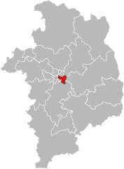
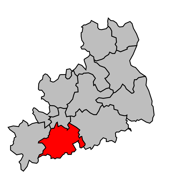
arrondissement of Bourges (arrondissement de Bourges)

- arrondissement of France
- Country:

- Capital: Bourges
- Coordinates: 47° 15' 0" N, 2° 25' 0" E


- GPS tracks (wikiloc): [Link]
- Area: 2798 sq km
- Population: 173577
- Wikipedia en: wiki(en)
- Wikipedia: wiki(fr)
- Wikidata storage: Wikidata: Q700723
- Wikipedia Commons Category: [Link]
- Freebase ID: [/m/0954zw]
- GeoNames ID: Alt: [3031004]
- INSEE arrondissement code: [181]
- GNS Unique Feature ID: -1414330
Includes regions:


canton of Bourges-2
- canton of France
- Country:
- Capital: Bourges
- Coordinates: 47° 5' 4" N, 2° 23' 47" E
- GPS tracks (wikiloc): [Link]
- Population: 15779
canton of Bourges-4
- canton of France
- Country:
- Capital: Bourges
- Coordinates: 47° 5' 4" N, 2° 23' 47" E
- GPS tracks (wikiloc): [Link]
- Population: 17111

canton of Bourges-3
- canton of France
- Country:
- Capital: Bourges
- Coordinates: 47° 5' 4" N, 2° 23' 47" E
- GPS tracks (wikiloc): [Link]
- Population: 15166

canton of Bourges-1
- canton of France
- Country:
- Capital: Bourges
- Coordinates: 47° 5' 4" N, 2° 23' 47" E
- GPS tracks (wikiloc): [Link]
- Population: 18015

canton of Aix-d'Angillon
- canton of France (until March 2015)
- Country:
- Capital: Les Aix-d'Angillon
- Coordinates: 47° 11' 56" N, 2° 34' 21" E
- GPS tracks (wikiloc): [Link]


canton of Chârost
- canton of France
- Country:
- Capital: Chârost
- Coordinates: 46° 59' 37" N, 2° 7' 1" E
- GPS tracks (wikiloc): [Link]
- Population: 14313

canton of Henrichemont
- canton in the French region of Centre-Val de Loire
- Country:
- Capital: Henrichemont
- Coordinates: 47° 18' 13" N, 2° 31' 30" E
- GPS tracks (wikiloc): [Link]


canton of Sancergues
- canton of France
- Country:
- Capital: Sancergues
- Coordinates: 47° 9' 22" N, 2° 55' 3" E
- GPS tracks (wikiloc): [Link]
canton of Saint-Martin-d'Auxigny
- canton of France
- Country:
- Capital: Saint-Martin-d'Auxigny
- Coordinates: 47° 12' 16" N, 2° 25' 3" E
- GPS tracks (wikiloc): [Link]
- Population: 16908


canton of Sancerre
- canton of France
- Country:
- Capital: Sancerre
- Coordinates: 47° 19' 55" N, 2° 50' 23" E
- GPS tracks (wikiloc): [Link]
- Population: 18798

canton of Saint-Doulchard
- canton of France
- Country:
- Capital: Saint-Doulchard
- Coordinates: 47° 6' 20" N, 2° 21' 27" E
- GPS tracks (wikiloc): [Link]
- Population: 14843

canton of Vailly-sur-Sauldre
- canton of France (until March 2015)
- Country:
- Capital: Vailly-sur-Sauldre
- Coordinates: 47° 27' 31" N, 2° 39' 4" E
- GPS tracks (wikiloc): [Link]
Shares border with regions:


arrondissement of Nevers
- arrondissement of France
- Country:
- Capital: Nevers
- Coordinates: 46° 55' 0" N, 3° 20' 0" E
- GPS tracks (wikiloc): [Link]
- Area: 2020 sq km
- Population: 117173