Hohenhameln (Hohenhameln)
- municipality of Germany
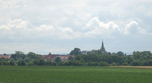
Hohenhameln, a charming village located in Lower Saxony, Germany, is surrounded by scenic landscapes that are ideal for hiking enthusiasts. While it may not be one of the more famous hiking destinations, it offers a peaceful experience for those looking to explore the countryside.
Hiking Trails:
-
Local Paths: The area around Hohenhameln features various local paths that wind through fields, forests, and rural landscapes. These trails can be quiet and allow hikers to connect with nature.
-
Circular Routes: There are several circular hiking routes that can be explored, usually ranging from easy to moderate difficulty. These often connect with nearby villages and showcase the agricultural beauty of the region.
-
Nature Reserves: Consider venturing to nearby nature reserves or parks that might offer more structured trails and opportunities for bird-watching and wildlife observation.
Terrain and Difficulty:
- The terrain around Hohenhameln is generally flat, making it suitable for hikers of all levels, including families and beginners.
- Some trails may have uneven surfaces, particularly in forested areas, so appropriate footwear is recommended.
Best Times to Hike:
- Spring (April to June) and autumn (September to November) are particularly lovely times for hiking, with mild temperatures and vibrant scenery.
- Summer can be warm, while winter may provide opportunities for winter hiking, though snow can make paths more challenging.
Recommendations:
- Always check local trail maps and weather conditions before heading out.
- It’s advisable to bring enough water and snacks, especially for longer hikes.
- Consider taking a camera as the landscapes around Hohenhameln can be quite picturesque.
Hiking in Hohenhameln can be a delightful way to enjoy the tranquility of the German countryside, so take your time to explore and enjoy the natural beauty around you!
- Country:

- Postal Code: 31249
- Local Dialing Code: 05128
- Licence Plate Code: PE
- Coordinates: 52° 15' 27" N, 10° 3' 51" E


- GPS tracks (wikiloc): [Link]
- AboveSeaLevel: 104 м m
- Area: 69.42 sq km
- Population: 9174
- Web site: https://www.hohenhameln.de/
- Wikipedia en: wiki(en)
- Wikipedia: wiki(de)
- Wikidata storage: Wikidata: Q569132
- Wikipedia Commons Category: [Link]
- Freebase ID: [/m/0chd14]
- Freebase ID: [/m/0chd14]
- GeoNames ID: Alt: [2901731]
- GeoNames ID: Alt: [2901731]
- VIAF ID: Alt: [247161282]
- VIAF ID: Alt: [247161282]
- OSM relation ID: [337283]
- OSM relation ID: [337283]
- GND ID: Alt: [4025548-7]
- GND ID: Alt: [4025548-7]
- WOEID: [661194]
- WOEID: [661194]
- TGN ID: [1039644]
- TGN ID: [1039644]
- Historical Gazetteer (GOV) ID: [HOHELNJO52AG]
- Historical Gazetteer (GOV) ID: [HOHELNJO52AG]
- German municipality key: 03157002
- German municipality key: 03157002
Shares border with regions:


Ilsede
- municipality of Germany
Ilsede is a small town located in Lower Saxony, Germany, which offers access to various hiking opportunities around the region, particularly in the nearby Harz mountains and other natural landscapes. Here are some highlights and tips for hiking in and around Ilsede:...
- Country:

- Postal Code: 31241
- Local Dialing Code: 05174; 05172
- Licence Plate Code: PE
- Coordinates: 52° 16' 0" N, 10° 11' 0" E


- GPS tracks (wikiloc): [Link]
- AboveSeaLevel: 75 м m
- Area: 72.03 sq km
- Population: 21530
- Web site: [Link]


Harsum
- municipality of Germany
Harsum, located in Lower Saxony, Germany, is a charming area that offers various outdoor activities, including hiking. While it may not be as well-known as some larger hiking destinations, there are several trails and natural areas worth exploring....
- Country:

- Postal Code: 31177
- Local Dialing Code: 05128; 05127
- Licence Plate Code: HI
- Coordinates: 52° 12' 0" N, 9° 57' 0" E


- GPS tracks (wikiloc): [Link]
- AboveSeaLevel: 70 м m
- Area: 49.93 sq km
- Population: 11367
- Web site: [Link]


Algermissen
- municipality of Germany
Algermissen is a small municipality located in Lower Saxony, Germany. While it may not be as well-known for hiking as larger natural parks or mountainous regions, there are still opportunities for outdoor activities in and around the area....
- Country:

- Postal Code: 31191
- Local Dialing Code: 05126
- Licence Plate Code: HI
- Coordinates: 52° 15' 12" N, 9° 58' 9" E


- GPS tracks (wikiloc): [Link]
- AboveSeaLevel: 79 м m
- Area: 35.62 sq km
- Population: 7840
- Web site: [Link]


Sehnde
- municipality of Germany
Sehnde is a quaint town located in Lower Saxony, Germany, not too far from Hanover. While it's not primarily known as a hiking destination, there are several beautiful trails and natural areas around Sehnde that outdoor enthusiasts can enjoy....
- Country:

- Postal Code: 31319
- Local Dialing Code: 05138; 05132
- Licence Plate Code: H
- Coordinates: 52° 18' 58" N, 9° 57' 51" E


- GPS tracks (wikiloc): [Link]
- AboveSeaLevel: 53 м m
- Area: 103.58 sq km
- Population: 23584
- Web site: [Link]


Lehrte
- town in the district of Hanover, in Lower Saxony, Germany
Lehrte, located in Lower Saxony, Germany, offers a range of hiking opportunities for outdoor enthusiasts. While it is more of an urban area, there are still several options in and around Lehrte where you can enjoy nature and hiking....
- Country:

- Postal Code: 31275
- Local Dialing Code: 05175; 05136; 05132
- Licence Plate Code: H
- Coordinates: 52° 22' 21" N, 9° 58' 37" E


- GPS tracks (wikiloc): [Link]
- AboveSeaLevel: 62 м m
- Area: 127000000 sq km
- Population: 43720
- Web site: [Link]

