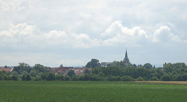
Sehnde (Sehnde)

- municipality of Germany
 Hiking in Sehnde
Sehnde is a quaint town located in Lower Saxony, Germany, not too far from Hanover. While it's not primarily known as a hiking destination, there are several beautiful trails and natural areas around Sehnde that outdoor enthusiasts can enjoy.
Hiking Trails and Areas
-
Local Parks and Nature Reserves:
- Sehnder Moor: This nature reserve is a great spot for walking and enjoying the local flora and fauna. The paths are relatively easy, making them suitable for families or novice hikers.
-
Loop Trails:
- There are several loop trails around Sehnde that connect various natural sights and parks in the area. These trails usually offer scenic views and can be explored in a few hours.
-
Nearby Regions:
- Hannover Region: Just a short distance from Sehnde, you can explore the hiking trails in the nearby Herrenhausen Gardens or the larger nature areas around Hanover, such as the Deister hills, which offer a range of trails for different skill levels.
-
Local Amenities:
- Many trails start near parks or recreation areas where you can find amenities such as restrooms and picnic areas, making it easier for family outings.
Hiking Tips
- Get a Trail Map: It's helpful to have a local map or a GPS application to guide you, especially in less-marked areas.
- Check Weather Conditions: Be aware of the weather before heading out, as conditions can change rapidly.
- Appropriate Gear: Wear sturdy, comfortable shoes, and dress in layers to account for changes in temperature throughout the hike.
- Stay Hydrated and Bring Snacks: Even on shorter hikes, it’s important to have water and some energy-boosting snacks with you.
Local Events
Keep an eye out for local hiking events or guided tours that may be offered, especially in larger protected areas or during the hiking season.
Exploring the trails around Sehnde can offer a peaceful retreat and an opportunity to connect with nature in a scenic part of Germany. Happy hiking!
- Country:

- Postal Code: 31319
- Local Dialing Code: 05138; 05132
- Licence Plate Code: H
- Coordinates: 52° 18' 58" N, 9° 57' 51" E


- GPS tracks (wikiloc): [Link]
- AboveSeaLevel: 53 м m
- Area: 103.58 sq km
- Population: 23584
- Web site: https://www.sehnde.de/
- Wikipedia en: wiki(en)
- Wikipedia: wiki(de)
- Wikidata storage: Wikidata: Q625095
- Wikipedia Commons Category: [Link]
- Wikipedia Commons Maps Category: [Link]
- Freebase ID: [/m/05lrtl]
- GeoNames ID: Alt: [2833475]
- VIAF ID: Alt: [243479030]
- OSM relation ID: [1184254]
- GND ID: Alt: [4118569-9]
- archINFORM location ID: [10801]
- MusicBrainz area ID: [3e32d813-daad-455e-941f-7a379edabf62]
- WOEID: [694283]
- German municipality key: 03241016
Shares border with regions:


Laatzen
- town in the district of Hanover, in Lower Saxony, Germany
Hiking in Laatzen
Laatzen, located in Lower Saxony, Germany, offers access to several beautiful hiking opportunities, particularly within the surrounding areas, such as the nearby Hannover region and various trails in natural reserves. Here are some key points to consider if you're interested in hiking in or around Laatzen:...
- Country:
- Postal Code: 30880
- Local Dialing Code: 0511; 05102
- Licence Plate Code: H
- Coordinates: 52° 19' 0" N, 9° 48' 0" E
- GPS tracks (wikiloc): [Link]
- AboveSeaLevel: 46 м m
- Area: 34.05 sq km
- Population: 40939
- Web site: [Link]


Hanover
- capital city of the German federated state of Lower Saxony
Hiking in Hanover
Hanover, situated in lower Saxony, Germany, offers a variety of hiking opportunities that cater to different skill levels and preferences. Here are some highlights:...
- Country:
- Postal Code: 30159–30659
- Local Dialing Code: 0511
- Licence Plate Code: H
- Coordinates: 52° 22' 28" N, 9° 44' 19" E
- GPS tracks (wikiloc): [Link]
- AboveSeaLevel: 55 м m
- Area: 204.30 sq km
- Population: 532864
- Web site: [Link]


Isernhagen
- Municipality in Germany
Hiking in Isernhagen
Isernhagen, located in Lower Saxony, Germany, is primarily known for its quaint villages, scenic landscapes, and proximity to the city of Hannover. While it may not have the rugged mountain trails that larger national parks or mountainous regions offer, there are still plenty of opportunities for enjoyable hiking experiences in and around Isernhagen....
- Country:
- Postal Code: 30916
- Local Dialing Code: 05139; 05136; 0511
- Licence Plate Code: H
- Coordinates: 52° 26' 3" N, 9° 51' 26" E
- GPS tracks (wikiloc): [Link]
- AboveSeaLevel: 58 м m
- Area: 59.72 sq km
- Population: 24219
- Web site: [Link]


Burgdorf
- municipality in Region Hannover, Germany
Hiking in Burgdorf
Burgdorf is a charming small town located just northeast of Hanover, Germany, and offers a variety of hiking opportunities for all levels of experience. Here are some aspects to consider when planning a hiking trip in the Burgdorf area:...
- Country:
- Postal Code: 31303
- Local Dialing Code: 05136; 05085
- Licence Plate Code: H
- Coordinates: 52° 27' 0" N, 10° 0' 30" E
- GPS tracks (wikiloc): [Link]
- AboveSeaLevel: 56 м m
- Area: 112.26 sq km
- Population: 30320
- Web site: [Link]


Hohenhameln
- municipality of Germany
Hiking in Hohenhameln
Hohenhameln, a charming village located in Lower Saxony, Germany, is surrounded by scenic landscapes that are ideal for hiking enthusiasts. While it may not be one of the more famous hiking destinations, it offers a peaceful experience for those looking to explore the countryside....
- Country:
- Postal Code: 31249
- Local Dialing Code: 05128
- Licence Plate Code: PE
- Coordinates: 52° 15' 27" N, 10° 3' 51" E
- GPS tracks (wikiloc): [Link]
- AboveSeaLevel: 104 м m
- Area: 69.42 sq km
- Population: 9174
- Web site: [Link]

Algermissen
- municipality of Germany
Hiking in Algermissen
Algermissen is a small municipality located in Lower Saxony, Germany. While it may not be as well-known for hiking as larger natural parks or mountainous regions, there are still opportunities for outdoor activities in and around the area....
- Country:
- Postal Code: 31191
- Local Dialing Code: 05126
- Licence Plate Code: HI
- Coordinates: 52° 15' 12" N, 9° 58' 9" E
- GPS tracks (wikiloc): [Link]
- AboveSeaLevel: 79 м m
- Area: 35.62 sq km
- Population: 7840
- Web site: [Link]


Lehrte
- town in the district of Hanover, in Lower Saxony, Germany
Hiking in Lehrte
Lehrte, located in Lower Saxony, Germany, offers a range of hiking opportunities for outdoor enthusiasts. While it is more of an urban area, there are still several options in and around Lehrte where you can enjoy nature and hiking....
- Country:
- Postal Code: 31275
- Local Dialing Code: 05175; 05136; 05132
- Licence Plate Code: H
- Coordinates: 52° 22' 21" N, 9° 58' 37" E
- GPS tracks (wikiloc): [Link]
- AboveSeaLevel: 62 м m
- Area: 127000000 sq km
- Population: 43720
- Web site: [Link]