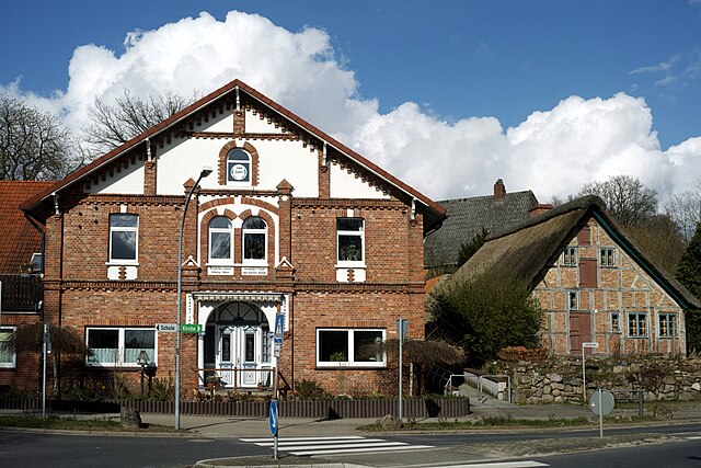
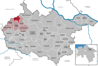
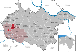
Hollenstedt (Hollenstedt)

- municipality of Germany
 Hiking in Hollenstedt
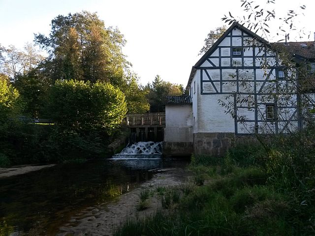
Hollenstedt, located in Lower Saxony, Germany, offers a variety of scenic landscapes for hiking enthusiasts. While the area may not be as famous for hiking as some other regions in Germany, there are several lovely trails and natural sights worth exploring. Here are some highlights:
Trails & Routes
-
Local Trails: Hollenstedt features a network of local trails that wind through picturesque countryside, forests, and fields. These trails may vary in difficulty and length, making them suitable for all skill levels, from families to seasoned hikers.
-
Schnuckeweg Trail: This trail is known for its charming views and serene environment. It often meanders through small villages and lush farmland, offering a glimpse of rural life in Lower Saxony.
-
Nature Reserves: Explore surrounding nature reserves, such as the Lüneburg Heath Nature Reserve. While this is a bit farther away, it's a popular destination for hiking with expansive heathland, diverse flora, and unique wildlife.
What to Expect
-
Flora & Fauna: Expect to see a variety of native plants and wildlife, particularly in the quieter, less disturbed areas of the trails. Birdwatching can also be rewarding in these regions.
-
Scenic Views: The region has rolling hills, wooded areas, and open fields, offering a diverse range of beautiful landscapes to enjoy.
-
Cultural Landmarks: Along some trails, you may encounter local landmarks, historical sites, and charming villages that add cultural depth to your hiking experience.
Tips for Hiking in Hollenstedt
-
Preparation: Always check trail conditions and maps beforehand. Local tourism offices can provide up-to-date information on route conditions.
-
Stay Hydrated: Bring plenty of water, especially during warmer months, as some trails may not have easy access to water sources.
-
Appropriate Gear: Wear sturdy hiking boots and comfortable clothing suitable for the weather. Layering is essential as temperatures can change quickly.
-
Respect the Environment: Follow Leave No Trace principles to preserve the natural beauty of the area.
Local Amenities
After a day of hiking, you can find cozy cafes and restaurants in Hollenstedt where you can relax and enjoy local cuisine. Accommodations may also be available if you plan to explore the area over a few days.
Overall, hiking in Hollenstedt can provide a peaceful escape into nature, allowing you to enjoy the beauty of Lower Saxony at a leisurely pace. Enjoy your hike!
- Country:

- Postal Code: 21279
- Local Dialing Code: 04165
- Licence Plate Code: WL
- Coordinates: 53° 22' 0" N, 9° 43' 0" E


- GPS tracks (wikiloc): [Link]
- AboveSeaLevel: 24 м m
- Area: 21.84 sq km
- Population: 3677
- Web site: https://www.hollenstedt.de/
- Wikipedia en: wiki(en)
- Wikipedia: wiki(de)
- Wikidata storage: Wikidata: Q570120
- Wikipedia Commons Category: [Link]
- Freebase ID: [/m/0c72m7]
- Freebase ID: [/m/0c72m7]
- GeoNames ID: Alt: [6552637]
- GeoNames ID: Alt: [6552637]
- VIAF ID: Alt: [126671234]
- VIAF ID: Alt: [126671234]
- OSM relation ID: [306358]
- OSM relation ID: [306358]
- GND ID: Alt: [4025627-3]
- GND ID: Alt: [4025627-3]
- Library of Congress authority ID: Alt: [n80123602]
- Library of Congress authority ID: Alt: [n80123602]
- MusicBrainz area ID: [42853c02-a9e5-4a60-8d03-b0bdde58bd08]
- MusicBrainz area ID: [42853c02-a9e5-4a60-8d03-b0bdde58bd08]
- German municipality key: 03353019
- German municipality key: 03353019
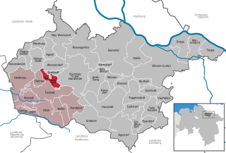
Includes regions:
Staersbeck
- human settlement in Germany
Hiking in Staersbeck
Staersbeck is a fictional location, so I can't provide specific information about it. However, if you are interested in exploring hiking opportunities in general or in a real-life location similar to what Staersbeck might represent, I can offer some helpful tips on what to look for when hiking in any new area....
- Country:
- Postal Code: 21279
- Coordinates: 53° 23' 14" N, 9° 41' 7" E
- GPS tracks (wikiloc): [Link]
Ochtmannsbruch
- human settlement in Germany
Hiking in Ochtmannsbruch
Ochtmannsbruch is located in Germany, specifically within the North Rhine-Westphalia region, and is part of the larger natural area of the Sauerland. This region is renowned for its picturesque landscapes, dense forests, and a variety of hiking trails suited for different experience levels....
- Country:
- Postal Code: 21279
- Local Dialing Code: 04165
- Coordinates: 53° 20' 31" N, 9° 41' 41" E
- GPS tracks (wikiloc): [Link]
Shares border with regions:
Oldendorf
Hiking in Oldendorf
Oldendorf (Appel) is a charming village located in Lower Saxony, Germany, and it serves as a great starting point for hiking enthusiasts looking to explore the natural beauty of the area. Here are some key points to consider when hiking in and around Oldendorf:...
- Country:
- Coordinates: 53° 22' 45" N, 9° 45' 20" E
- GPS tracks (wikiloc): [Link]
Heidenau
- municipality in Lower Saxony, Germany
Hiking in Heidenau
Heidenau, located in Lower Saxony, is surrounded by beautiful landscapes that offer a variety of hiking opportunities. The area is characterized by rolling hills, forests, and scenic views, making it a great destination for both casual walkers and more experienced hikers....
- Country:
- Postal Code: 21258
- Local Dialing Code: 04182
- Licence Plate Code: WL
- Coordinates: 53° 19' 0" N, 9° 40' 0" E
- GPS tracks (wikiloc): [Link]
- AboveSeaLevel: 48 м m
- Area: 38.9 sq km
- Population: 2222
- Web site: [Link]


Wenzendorf
- municipality of Germany
Hiking in Wenzendorf
Wenzendorf, a small village located in Lower Saxony, Germany, offers a serene environment for hiking enthusiasts. While the village itself may not be a well-known hiking destination, its surrounding landscapes and trails provide plenty of opportunities for those looking to explore nature....
- Country:
- Postal Code: 21279
- Local Dialing Code: 04165
- Licence Plate Code: WL
- Coordinates: 53° 21' 0" N, 9° 46' 0" E
- GPS tracks (wikiloc): [Link]
- AboveSeaLevel: 64 м m
- Area: 21.47 sq km
- Population: 1434
- Web site: [Link]
Moisburg
- municipality of Germany
Hiking in Moisburg
Moisburg, located in Lower Saxony, Germany, is a small town that offers a quaint atmosphere and access to beautiful natural scenery. While Moisburg itself may not be widely recognized as a major hiking destination, its surroundings provide opportunities for outdoor activities, including hiking....
- Country:
- Postal Code: 21647
- Local Dialing Code: 04165
- Licence Plate Code: WL
- Coordinates: 53° 23' 59" N, 9° 41' 59" E
- GPS tracks (wikiloc): [Link]
- AboveSeaLevel: 15 м m
- Area: 11.25 sq km
- Population: 1936
- Web site: [Link]


Appel
- municipality of Germany
Hiking in Appel
Appel, Germany, is a small village located in the Lower Saxony region, known for its picturesque landscapes and proximity to the Lüneburg Heath (Lüneburger Heide), a beautiful area popular for hiking and nature activities. Although Appel itself may not be a major hiking destination, it serves as an excellent base for exploring the surrounding natural beauty....
- Country:
- Postal Code: 21279
- Local Dialing Code: 04165
- Licence Plate Code: WL
- Coordinates: 53° 23' 35" N, 9° 44' 50" E
- GPS tracks (wikiloc): [Link]
- AboveSeaLevel: 40 м m
- Area: 15.42 sq km
- Population: 1962
- Web site: [Link]
Kakenstorf
- municipality of Germany
Hiking in Kakenstorf
Kakenstorf is a small village in Lower Saxony, Germany, located near the larger city of Hamburg. While it may not be a prominent hiking destination, there are several opportunities for nature walks and hikes in the surrounding areas, particularly in the Lüneburg Heath (Lüneburger Heide) region, which is accessible from Kakenstorf....
- Country:
- Postal Code: 21255
- Local Dialing Code: 04186
- Licence Plate Code: WL
- Coordinates: 53° 19' 0" N, 9° 46' 0" E
- GPS tracks (wikiloc): [Link]
- AboveSeaLevel: 46 м m
- Area: 38.71 sq km
- Population: 1393
- Web site: [Link]


Regesbostel
- municipality of Germany
Hiking in Regesbostel
Regesbostel is a small village located in Lower Saxony, Germany. While it may not be as well-known as some of the larger hiking destinations in Germany, it offers opportunities for trekking and enjoying nature in the surrounding areas. Here are some key points to consider when hiking in and around Regesbostel:...
- Country:
- Postal Code: 21649
- Local Dialing Code: 04165
- Licence Plate Code: WL
- Coordinates: 53° 22' 0" N, 9° 39' 0" E
- GPS tracks (wikiloc): [Link]
- AboveSeaLevel: 34 м m
- Area: 16.27 sq km
- Population: 1059
- Web site: [Link]

Dohren
- municipality in the district of Harburg, in Lower Saxony, Germany
Hiking in Dohren
Dohren is a small town in Lower Saxony, Germany, known for its picturesque countryside and access to various outdoor activities, including hiking. While it may not have an extensive network of marked trails like some larger national parks, there are still opportunities for enjoyable hikes in the surrounding area....
- Country:
- Postal Code: 21255
- Local Dialing Code: 04182
- Licence Plate Code: WL
- Coordinates: 53° 18' 18" N, 9° 42' 9" E
- GPS tracks (wikiloc): [Link]
- AboveSeaLevel: 54 м m
- Area: 11.25 sq km
- Population: 1196
- Web site: [Link]