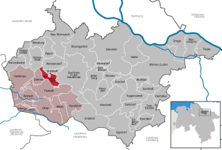
Wenzendorf (Wenzendorf)

- municipality of Germany
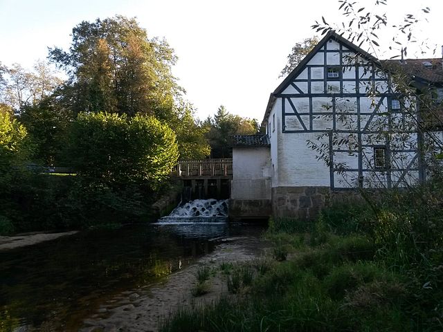
 Hiking in Wenzendorf
Wenzendorf, a small village located in Lower Saxony, Germany, offers a serene environment for hiking enthusiasts. While the village itself may not be a well-known hiking destination, its surrounding landscapes and trails provide plenty of opportunities for those looking to explore nature.
Hiking Trails
-
Local Paths and Routes: There are various local walking and hiking paths that wind through the countryside, offering a chance to experience the idyllic scenery of the region. These trails often lead through fields, forests, and along rivers.
-
Regional Trails: The area around Wenzendorf may connect to larger networks of trails that explore the Lüneburg Heath (Lüneburger Heide), which is famous for its heathland, rolling hills, and unique flora and fauna. This is a great spot for longer hikes.
Flora and Fauna
- Nature Diversity: Hikers can expect to see a variety of plant species, especially in heathland areas, and may encounter local wildlife such as deer, birds, and various insects.
Tips for Hiking in Wenzendorf
- Maps and Navigation: It's helpful to have a local hiking map or app to ensure you stay on the trails and find your way easily.
- Weather Preparedness: Check the weather forecast before heading out. Carry a rain jacket and layers, as weather can change quickly.
- Footwear: Wear sturdy hiking shoes or boots to accommodate varied terrain.
- Hydration and Snacks: Bring enough water and some snacks to keep your energy up during your hikes.
- Safety: Hike with a buddy if possible, and inform someone of your hiking plan, especially if you’re venturing onto less traveled paths.
Conclusion
Though Wenzendorf may not be a tourist hotspot, it can be a peaceful retreat for hikers looking to enjoy the beauty of the Lower Saxony countryside. Combining local trails with larger regional opportunities can create memorable hiking experiences in this charming area.
- Country:

- Postal Code: 21279
- Local Dialing Code: 04165
- Licence Plate Code: WL
- Coordinates: 53° 21' 0" N, 9° 46' 0" E


- GPS tracks (wikiloc): [Link]
- AboveSeaLevel: 64 м m
- Area: 21.47 sq km
- Population: 1434
- Web site: http://www.hollenstedt.de/internet/page.php?naviID=6000026&site=6000042&typ=2&rubrik=6000017
- Wikipedia en: wiki(en)
- Wikipedia: wiki(de)
- Wikidata storage: Wikidata: Q376823
- Wikipedia Commons Category: [Link]
- Freebase ID: [/m/02ryf2y]
- Freebase ID: [/m/02ryf2y]
- GeoNames ID: Alt: [2811011]
- GeoNames ID: Alt: [2811011]
- VIAF ID: Alt: [233922548]
- VIAF ID: Alt: [233922548]
- OSM relation ID: [280558]
- OSM relation ID: [280558]
- GND ID: Alt: [7633190-8]
- GND ID: Alt: [7633190-8]
- MusicBrainz area ID: [17344544-62e4-415e-828b-f4c34206763b]
- MusicBrainz area ID: [17344544-62e4-415e-828b-f4c34206763b]
- German municipality key: 03353039
- German municipality key: 03353039
Includes regions:
Klauenburg
- human settlement in Germany
Hiking in Klauenburg
Klauenburg may not be widely recognized as a specific hiking destination, as it could refer to a localized area or a lesser-known region. However, if you're considering hiking in a similar-sounding location or a specific area within a country that features this name, I'd be happy to provide general information on what to expect when hiking in hilly or rural areas....
- Country:
- Postal Code: 21279
- Local Dialing Code: 04165
- Coordinates: 53° 20' 54" N, 9° 47' 47" E
- GPS tracks (wikiloc): [Link]
Shares border with regions:


Buchholz in der Nordheide
- town in the district of Harburg, in Lower Saxony, Germany
Hiking in Buchholz in der Nordheide
Buchholz in der Nordheide, located in Lower Saxony, Germany, is surrounded by picturesque landscapes that offer excellent opportunities for hiking. While it may not be as well-known as some of Germany's larger hiking destinations, it has several trails and natural areas that can be quite appealing for outdoor enthusiasts....
- Country:
- Postal Code: 21244
- Local Dialing Code: 04181
- Licence Plate Code: WL
- Coordinates: 53° 19' 43" N, 9° 51' 43" E
- GPS tracks (wikiloc): [Link]
- AboveSeaLevel: 55 м m
- Area: 74.62 sq km
- Population: 38689
- Web site: [Link]


Neu Wulmstorf
- German municipality in Lower Saxony
Hiking in Neu Wulmstorf
Neu Wulmstorf is located in Lower Saxony, Germany, and while it may not be a major hiking destination like some national parks, it does offer some pleasant outdoor experiences for those looking to enjoy nature and hiking....
- Country:
- Postal Code: 21629
- Local Dialing Code: 04168; 040
- Licence Plate Code: WL
- Coordinates: 53° 25' 22" N, 9° 47' 23" E
- GPS tracks (wikiloc): [Link]
- AboveSeaLevel: 49 м m
- Area: 56.16 sq km
- Population: 21159
- Web site: [Link]
Hollenstedt
- municipality of Germany
Hiking in Hollenstedt
Hollenstedt, located in Lower Saxony, Germany, offers a variety of scenic landscapes for hiking enthusiasts. While the area may not be as famous for hiking as some other regions in Germany, there are several lovely trails and natural sights worth exploring. Here are some highlights:...
- Country:
- Postal Code: 21279
- Local Dialing Code: 04165
- Licence Plate Code: WL
- Coordinates: 53° 22' 0" N, 9° 43' 0" E
- GPS tracks (wikiloc): [Link]
- AboveSeaLevel: 24 м m
- Area: 21.84 sq km
- Population: 3677
- Web site: [Link]


Appel
- municipality of Germany
Hiking in Appel
Appel, Germany, is a small village located in the Lower Saxony region, known for its picturesque landscapes and proximity to the Lüneburg Heath (Lüneburger Heide), a beautiful area popular for hiking and nature activities. Although Appel itself may not be a major hiking destination, it serves as an excellent base for exploring the surrounding natural beauty....
- Country:
- Postal Code: 21279
- Local Dialing Code: 04165
- Licence Plate Code: WL
- Coordinates: 53° 23' 35" N, 9° 44' 50" E
- GPS tracks (wikiloc): [Link]
- AboveSeaLevel: 40 м m
- Area: 15.42 sq km
- Population: 1962
- Web site: [Link]
Drestedt
- municipality of Germany
Hiking in Drestedt
Drestedt is a small town located in Lower Saxony, Germany. While it may not be widely known for extensive hiking trails, its proximity to scenic areas and regional parks offers some opportunities for outdoor enthusiasts. Here’s what you need to know about hiking around Drestedt:...
- Country:
- Postal Code: 21279
- Local Dialing Code: 04186
- Licence Plate Code: WL
- Coordinates: 53° 20' 0" N, 9° 46' 0" E
- GPS tracks (wikiloc): [Link]
- AboveSeaLevel: 48 м m
- Area: 5.71 sq km
- Population: 768
- Web site: [Link]
Kakenstorf
- municipality of Germany
Hiking in Kakenstorf
Kakenstorf is a small village in Lower Saxony, Germany, located near the larger city of Hamburg. While it may not be a prominent hiking destination, there are several opportunities for nature walks and hikes in the surrounding areas, particularly in the Lüneburg Heath (Lüneburger Heide) region, which is accessible from Kakenstorf....
- Country:
- Postal Code: 21255
- Local Dialing Code: 04186
- Licence Plate Code: WL
- Coordinates: 53° 19' 0" N, 9° 46' 0" E
- GPS tracks (wikiloc): [Link]
- AboveSeaLevel: 46 м m
- Area: 38.71 sq km
- Population: 1393
- Web site: [Link]