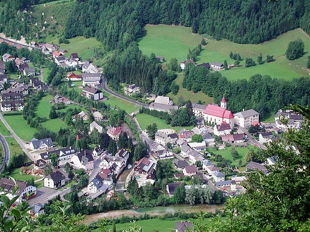
Hollenstein an der Ybbs (Hollenstein an der Ybbs)
- Austrian community
 Hiking in Hollenstein an der Ybbs
Hollenstein an der Ybbs, a charming village situated in the Ybbstal valley of Austria, offers a variety of hiking opportunities that cater to all skill levels. Surrounded by beautiful landscapes, rolling hills, and lush forests, it’s an ideal spot for nature lovers.
Hiking Trails:
-
Hiking Paths: There are numerous well-marked hiking trails in and around Hollenstein an der Ybbs. Routes vary from easy walks to more challenging hikes, providing options for both families and seasoned hikers.
-
Nature Trails: The area is home to several nature trails that educate hikers about local flora and fauna. These paths often feature interpretation boards and are great for families or those looking for a leisurely stroll.
-
Ybbstal Hiking Trail: This well-known trail runs along the Ybbs river and connects various villages in the region. Portions of this trail can be accessed from Hollenstein and are perfect for a longer hike.
Scenic Views:
Hiking in this area rewards you with stunning views of the surrounding mountains and valleys. The diverse landscapes include meadows, dense forests, and picturesque riverbanks, making each hike a unique experience.
Best Time to Hike:
The ideal hiking season is from late spring to early autumn. Summer provides warm weather and long days, while the fall offers beautiful autumn foliage. Winter hiking can also be enjoyed in the surrounding areas, but be sure to check for snow conditions.
Preparation:
- Gear: Wear appropriate hiking gear, including sturdy shoes and weather-appropriate clothing.
- Maps: Carry a map or use a hiking app to navigate the trails. Local tourist information centers often provide maps.
Local Wildlife:
Keep an eye out for the diverse wildlife that inhabits the area. Birdwatchers, in particular, can enjoy spotting local species while hiking.
Accommodations and Facilities:
There are various accommodations available in Hollenstein an der Ybbs, including guesthouses and hotels. Some may even offer guided hiking tours for those interested in a more structured experience.
Conclusion:
Hollenstein an der Ybbs is a wonderful destination for hikers looking to explore the natural beauty of Austria's Ybbstal valley. Whether you want a leisurely walk or a challenging hike, you will find suitable trails that showcase the area's stunning landscapes.
- Country:

- Postal Code: 3343
- Local Dialing Code: 07445
- Licence Plate Code: AM
- Coordinates: 47° 48' 11" N, 14° 46' 20" E


- GPS tracks (wikiloc): [Link]
- AboveSeaLevel: 485 м m
- Area: 126.42 sq km
- Population: 1706
- Web site: http://www.hollenstein-ybbs.gv.at/
- Wikipedia en: wiki(en)
- Wikipedia: wiki(de)
- Wikidata storage: Wikidata: Q674059
- Wikipedia Commons Category: [Link]
- Freebase ID: [/m/02qsp6p]
- GeoNames ID: Alt: [2775613]
- VIAF ID: Alt: [240068788]
- Library of Congress authority ID: Alt: [no2003044914]
- Austrian municipality key: [30516]
Shares border with regions:

Gaflenz
- municipality in Austria
Hiking in Gaflenz
Gaflenz, located in Austria's Upper Austria region, is a lesser-known gem for hiking enthusiasts. Nestled within the scenic landscape of the Alps, it offers a variety of trails that cater to different skill levels, from leisurely strolls to challenging hikes....
- Country:
- Local Dialing Code: 07353
- Licence Plate Code: SE
- Coordinates: 47° 53' 49" N, 14° 43' 32" E
- GPS tracks (wikiloc): [Link]
- AboveSeaLevel: 478 м m
- Area: 59 sq km
- Population: 1954
- Web site: [Link]
Göstling an der Ybbs
- municipality in Austria
Hiking in Göstling an der Ybbs
Göstling an der Ybbs is a picturesque town located in the Ybbstal region of Lower Austria, surrounded by beautiful mountainous landscapes, making it a fantastic destination for hikers of all levels. The area offers a variety of hiking trails that cater to different abilities, from leisurely strolls to more challenging hikes....
- Country:
- Postal Code: 3345
- Local Dialing Code: 07484
- Licence Plate Code: SB
- Coordinates: 47° 49' 0" N, 14° 56' 0" E
- GPS tracks (wikiloc): [Link]
- AboveSeaLevel: 532 м m
- Area: 143.73 sq km
- Population: 2058
- Web site: [Link]

Altenmarkt bei Sankt Gallen
- municipality in Austria
Hiking in Altenmarkt bei Sankt Gallen
Altenmarkt bei Sankt Gallen, a picturesque village located in the Swiss canton of St. Gallen, offers a variety of stunning hiking opportunities for outdoor enthusiasts. Nestled in the foothills of the Alps, the area is renowned for its beautiful landscapes, lush forests, and panoramic mountain views....
- Country:
- Postal Code: 8934
- Local Dialing Code: 03632
- Licence Plate Code: LI
- Coordinates: 47° 43' 21" N, 14° 39' 7" E
- GPS tracks (wikiloc): [Link]
- AboveSeaLevel: 467 м m
- Area: 43.05 sq km
- Population: 822
- Web site: [Link]

Sankt Georgen am Reith
- municipality in Austria
Hiking in Sankt Georgen am Reith
Sankt Georgen am Reith is a charming village in Austria, nestled in the picturesque region of Lower Austria. It's surrounded by beautiful natural landscapes, making it an excellent destination for hiking enthusiasts of all levels. Here are some highlights of hiking in Sankt Georgen am Reith:...
- Country:
- Postal Code: 3344
- Local Dialing Code: 07484
- Licence Plate Code: AM
- Coordinates: 47° 50' 26" N, 14° 52' 47" E
- GPS tracks (wikiloc): [Link]
- AboveSeaLevel: 522 м m
- Area: 40.07 sq km
- Population: 578
- Web site: [Link]

Opponitz
- municipality in Austria
Hiking in Opponitz
Opponitz, located in Austria, is a picturesque village in the Lower Austria region, surrounded by beautiful natural landscapes, making it a great destination for hiking enthusiasts. The area offers a variety of trails suitable for different skill levels, providing opportunities to explore the scenic beauty of the surrounding hills, forests, and meadows....
- Country:
- Local Dialing Code: 07444
- Licence Plate Code: AM
- Coordinates: 47° 52' 0" N, 14° 49' 0" E
- GPS tracks (wikiloc): [Link]
- AboveSeaLevel: 422 м m
- Area: 39.66 sq km
- Population: 947
- Web site: [Link]
Weyer
- municipality in Austria
Hiking in Weyer
Weyer, located in the Upper Austria region, is a picturesque destination for hiking enthusiasts. The area is characterized by its stunning natural landscapes, including rolling hills, dense forests, and clear streams. Here are some aspects to consider when planning a hiking trip in Weyer:...
- Country:
- Licence Plate Code: SE
- Coordinates: 47° 51' 1" N, 14° 39' 31" E
- GPS tracks (wikiloc): [Link]
- AboveSeaLevel: 399 м m
- Area: 223.8 sq km
- Population: 4258
- Web site: [Link]
Landl
- municipality in Austria
Hiking in Landl
Landl is a picturesque area in Austria, typically associated with stunning landscapes, mountains, and numerous hiking trails suitable for various skill levels. Here are some highlights and tips for hiking in Landl:...
- Country:
- Postal Code: 8931
- Local Dialing Code: 03633
- Licence Plate Code: LI
- Coordinates: 47° 39' 3" N, 14° 44' 13" E
- GPS tracks (wikiloc): [Link]
- AboveSeaLevel: 520 м m
- Area: 104.3 sq km
- Population: 2720
- Web site: [Link]