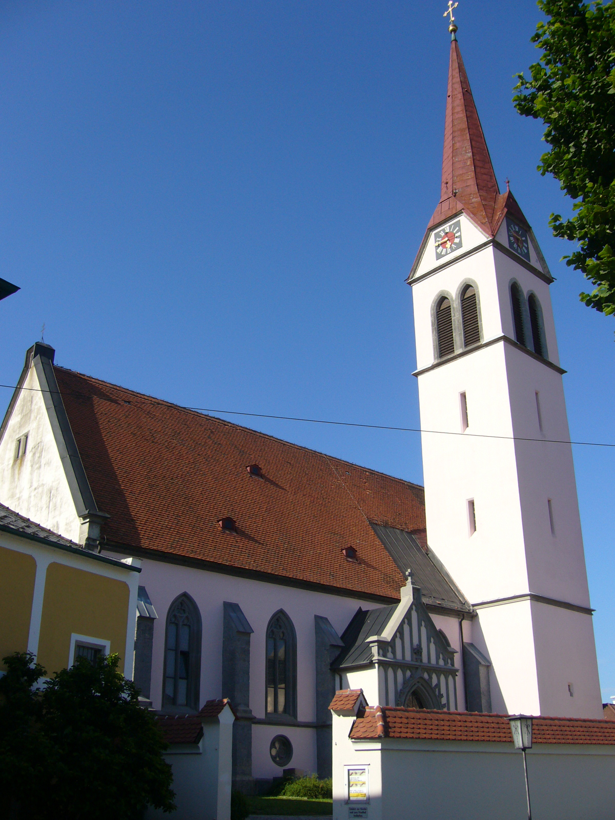
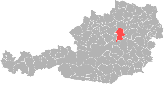
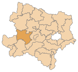
Amstetten District (Bezirk Amstetten)
- district in Austria
 Hiking in Amstetten District
Amstetten District, located in the Lower Austria region of Austria, offers a variety of hiking opportunities for outdoor enthusiasts. The region is characterized by its diverse landscapes, which include hills, forests, and charming rural scenery, making it an appealing destination for both casual walkers and experienced hikers.
Hiking Opportunities:
-
Trails: Amstetten boasts various marked hiking trails that cater to different skill levels. The region features several scenic routes ranging from easy walks suitable for families to more challenging hikes for experienced trekkers.
-
Natural Beauty: Hikers can enjoy beautiful views of the Mostviertel countryside, vineyards, and the rolling hills that define the area. The landscape includes lush forests, apple orchards, and picturesque villages.
-
Cultural Heritage: Along the hiking trails, visitors may encounter historical sites, quaint towns, and local attractions, such as churches, castles, and traditional farms, adding a cultural dimension to the hiking experience.
-
Accessibility: Many trails are easily accessible from Amstetten's main towns and can be reached by public transport, making it convenient for day trips or longer excursions.
-
Seasonal Hiking: Each season offers a unique experience. Spring brings blooming flowers and lush greenery, while autumn offers stunning foliage. Winter hiking might also be possible in some areas, providing a different perspective of the landscape.
Safety and Preparation:
- Gear: It's important to wear appropriate hiking footwear and clothing, and consider bringing hiking poles for added stability on uneven terrain.
- Weather: Always check the weather forecast before heading out, as conditions can change quickly in the region.
- Maps: Utilizing hiking maps or GPS apps can help with navigation and ensure you stay on marked trails.
Local Recommendations:
- Hiking Associations: Consider checking with local hiking clubs or associations for guided tours, organized events, or recommendations on the best trails to explore.
- Visitor Centers: Visit local tourism offices for maps, brochures, and up-to-date information regarding trail conditions and any relevant safety advice.
Amstetten District is a wonderful place for hiking, combining the beauty of nature with cultural experiences that can enrich your outdoor activities.
- Country:

- Capital: Amstetten
- Licence Plate Code: AM
- Coordinates: 48° 7' 0" N, 14° 52' 0" E


- GPS tracks (wikiloc): [Link]
- AboveSeaLevel: 602 м m
- Area: 1187.97 sq km
- Population: 115676
- Web site: http://www.noel.gv.at/service/bh/am/bham.htm
- Wikipedia en: wiki(en)
- Wikipedia: wiki(de)
- Wikidata storage: Wikidata: Q694449
- Wikipedia Commons Category: [Link]
- Freebase ID: [/m/0dm7sc]
- GeoNames ID: Alt: [2782554]
- VIAF ID: Alt: [134870433]
- GND ID: Alt: [4495238-7]
- archINFORM location ID: [14623]
- Library of Congress authority ID: Alt: [n80148147]
- NUTS code: [AT121]
Includes regions:
Zeillern
- municipality in Austria
Hiking in Zeillern
Zeillern is a small village located in Lower Austria, known for its beautiful natural surroundings, making it a great destination for hiking enthusiasts. The landscape around Zeillern offers a mix of rolling hills, forests, and scenic views, perfect for both casual walkers and more experienced hikers....
- Country:
- Local Dialing Code: 07472
- Licence Plate Code: AM
- Coordinates: 48° 7' 48" N, 14° 48' 29" E
- GPS tracks (wikiloc): [Link]
- AboveSeaLevel: 290 м m
- Area: 21.57 sq km
- Population: 1865
- Web site: [Link]
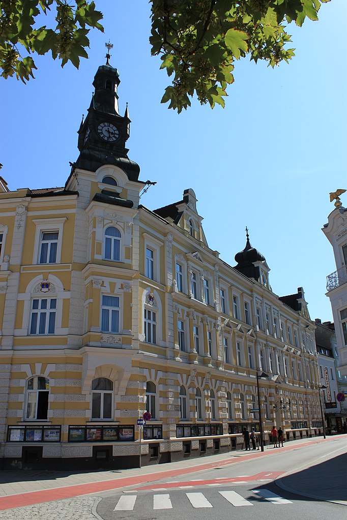
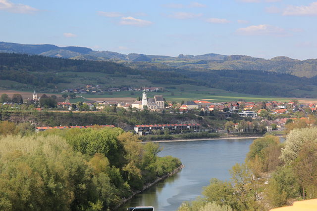
Amstetten
- municipality in Lower Austria
Hiking in Amstetten
Amstetten, located in Lower Austria, provides a variety of hiking opportunities for outdoor enthusiasts. The region is characterized by its picturesque landscapes, rolling hills, and lush forests, making it an ideal spot for both casual walkers and more experienced hikers....
- Country:
- Postal Code: 07472
- Local Dialing Code: 07472
- Licence Plate Code: AM
- Coordinates: 48° 7' 0" N, 14° 52' 0" E
- GPS tracks (wikiloc): [Link]
- AboveSeaLevel: 275 м m
- Area: 52.1 sq km
- Population: 23656
- Web site: [Link]
Haag
- municipality in Austria
Hiking in Haag
Haag, located in the Amstetten district of Lower Austria, offers a variety of hiking opportunities that cater to different skill levels and preferences. The area is surrounded by beautiful landscapes, including rolling hills, forests, and rivers, making it a picturesque destination for outdoor enthusiasts....
- Country:
- Postal Code: 3350
- Local Dialing Code: 07434
- Licence Plate Code: AM
- Coordinates: 48° 6' 44" N, 14° 33' 56" E
- GPS tracks (wikiloc): [Link]
- AboveSeaLevel: 346 м m
- Area: 54.96 sq km
- Population: 5548
- Web site: [Link]
Weistrach
- municipality in Austria
Hiking in Weistrach
Weistrach is a charming village located in the Upper Austria region, surrounded by beautiful rolling hills and lush landscapes, making it an excellent destination for hiking enthusiasts. Here are some key highlights and tips for hiking in Weistrach:...
- Country:
- Postal Code: 3351
- Local Dialing Code: 07477
- Licence Plate Code: AM
- Coordinates: 48° 3' 14" N, 14° 35' 2" E
- GPS tracks (wikiloc): [Link]
- AboveSeaLevel: 350 м m
- Area: 35.77 sq km
- Population: 2216
- Web site: [Link]
Sankt Georgen am Ybbsfelde
- municipality in Austria
Hiking in Sankt Georgen am Ybbsfelde
Sankt Georgen am Ybbsfelde, located in Lower Austria, is a charming area that offers a variety of hiking opportunities amidst beautiful landscapes. The region is characterized by rolling hills, lush forests, and scenic views of the surrounding countryside, making it a delightful destination for both casual walkers and more experienced hikers....
- Country:
- Postal Code: 3304
- Local Dialing Code: 07473
- Licence Plate Code: AM
- Coordinates: 48° 7' 46" N, 14° 57' 13" E
- GPS tracks (wikiloc): [Link]
- AboveSeaLevel: 272 м m
- Area: 22.83 sq km
- Population: 2886
- Web site: [Link]
Biberbach
- municipality in Austria
Hiking in Biberbach
Biberbach, located in Austria's beautiful Lower Austria region, is surrounded by stunning landscapes, making it a lovely destination for hiking enthusiasts. Here are some key points about hiking in Biberbach:...
- Country:
- Local Dialing Code: 07476
- Licence Plate Code: AM
- Coordinates: 48° 1' 0" N, 14° 41' 0" E
- GPS tracks (wikiloc): [Link]
- AboveSeaLevel: 355 м m
- Area: 28.37 sq km
- Population: 2270
- Web site: [Link]
Neustadtl an der Donau
- municipality in Austria
Hiking in Neustadtl an der Donau
Neustadtl an der Donau is a charming town located in the Austrian state of Upper Austria, situated along the Danube River. Hiking in this area offers a blend of scenic views, historical landmarks, and lush countryside. Here are some key points to consider when hiking around Neustadtl an der Donau:...
- Country:
- Postal Code: 3323
- Local Dialing Code: 07471
- Licence Plate Code: AM
- Coordinates: 48° 11' 36" N, 14° 54' 10" E
- GPS tracks (wikiloc): [Link]
- AboveSeaLevel: 507 м m
- Area: 47.89 sq km
- Population: 2143
- Web site: [Link]

Wolfsbach
- municipality in Austria
Hiking in Wolfsbach
Wolfsbach, located in Lower Austria, offers a serene environment for hikers and nature enthusiasts. This picturesque region is characterized by rolling hills, lush forests, and charming rural landscapes. Here are some highlights and tips for hiking in and around Wolfsbach:...
- Country:
- Postal Code: 3354
- Local Dialing Code: 07477
- Licence Plate Code: AM
- Coordinates: 48° 4' 47" N, 14° 40' 9" E
- GPS tracks (wikiloc): [Link]
- AboveSeaLevel: 384 м m
- Area: 31 sq km
- Population: 2011
- Web site: [Link]

Ardagger
- municipality in Austria
Hiking in Ardagger
Ardagger, located in the province of Lower Austria, offers a variety of hiking opportunities for outdoor enthusiasts. The region is characterized by picturesque landscapes, including the Danube River, lush forests, and rolling hills. Here are some highlights for hiking in and around Ardagger:...
- Country:
- Postal Code: 3321
- Local Dialing Code: 07479
- Licence Plate Code: AM
- Coordinates: 48° 10' 0" N, 14° 49' 0" E
- GPS tracks (wikiloc): [Link]
- AboveSeaLevel: 250 м m
- Area: 47.16 sq km
- Population: 3511
- Web site: [Link]

Seitenstetten
- municipality in Austria
Hiking in Seitenstetten
Seitenstetten, located in Austria's beautiful Lower Austria region, offers a picturesque setting for hiking enthusiasts. The area is characterized by lush landscapes, rolling hills, and peaceful forests, making it an ideal destination for nature lovers and those looking to escape into the outdoors....
- Country:
- Postal Code: 3353
- Local Dialing Code: 07477
- Licence Plate Code: AM
- Coordinates: 48° 2' 6" N, 14° 39' 15" E
- GPS tracks (wikiloc): [Link]
- AboveSeaLevel: 349 м m
- Area: 30.48 sq km
- Population: 3394
- Web site: [Link]

Sankt Georgen am Reith
- municipality in Austria
Hiking in Sankt Georgen am Reith
Sankt Georgen am Reith is a charming village in Austria, nestled in the picturesque region of Lower Austria. It's surrounded by beautiful natural landscapes, making it an excellent destination for hiking enthusiasts of all levels. Here are some highlights of hiking in Sankt Georgen am Reith:...
- Country:
- Postal Code: 3344
- Local Dialing Code: 07484
- Licence Plate Code: AM
- Coordinates: 47° 50' 26" N, 14° 52' 47" E
- GPS tracks (wikiloc): [Link]
- AboveSeaLevel: 522 м m
- Area: 40.07 sq km
- Population: 578
- Web site: [Link]
St. Valentin
- municipality in Austria
Hiking in St. Valentin
St. Valentin, located in the province of South Tyrol in northern Italy, offers a variety of hiking opportunities that cater to different skill levels and preferences. Nestled in the scenic Val d’Isarco, St. Valentin is surrounded by lush landscapes and beautiful mountain scenery. Here are some key points about hiking in the area:...
- Country:
- Local Dialing Code: 07435
- Licence Plate Code: AM
- Coordinates: 48° 10' 29" N, 14° 32' 0" E
- GPS tracks (wikiloc): [Link]
- AboveSeaLevel: 272 м m
- Area: 45.64 sq km
- Population: 9340
- Web site: [Link]
Allhartsberg
- municipality in Austria
Hiking in Allhartsberg
Allhartsberg, located in the beautiful region of Lower Austria, offers a variety of hiking opportunities that showcase its stunning landscapes, charming villages, and rich cultural heritage. Here are some key points to consider when planning a hike in Allhartsberg:...
- Country:
- Postal Code: 3365
- Local Dialing Code: 07448
- Licence Plate Code: AM
- Coordinates: 48° 2' 0" N, 14° 48' 0" E
- GPS tracks (wikiloc): [Link]
- AboveSeaLevel: 394 м m
- Area: 21.33 sq km
- Population: 2108
- Web site: [Link]

Ybbsitz
- municipality in Austria
Hiking in Ybbsitz
Ybbsitz, located in the beautiful region of Lower Austria, is known for its picturesque landscapes, rolling hills, and stunning natural scenery, making it an excellent destination for hiking enthusiasts. Here are some key points to consider when hiking in Ybbsitz:...
- Country:
- Local Dialing Code: 07443
- Licence Plate Code: AM
- Coordinates: 47° 56' 54" N, 14° 53' 38" E
- GPS tracks (wikiloc): [Link]
- AboveSeaLevel: 414 м m
- Area: 104.19 sq km
- Population: 3445
- Web site: [Link]

Sankt Pantaleon-Erla
- municipality in Austria
Hiking in Sankt Pantaleon-Erla
Sankt Pantaleon-Erla is a picturesque area in Austria known for its beautiful landscapes and outdoor activities, including hiking. Nestled amidst rolling hills and lush greenery, it offers various trails that cater to hikers of different skill levels....
- Country:
- Postal Code: 4303
- Local Dialing Code: 07435
- Licence Plate Code: AM
- Coordinates: 48° 11' 57" N, 14° 34' 17" E
- GPS tracks (wikiloc): [Link]
- AboveSeaLevel: 242 м m
- Area: 28.38 sq km
- Population: 2587
- Web site: [Link]
Kematen an der Ybbs
- municipality in Austria
Hiking in Kematen an der Ybbs
Kematen an der Ybbs is a picturesque village located in the state of Upper Austria, surrounded by beautiful natural landscapes that offer various hiking opportunities. The region is characterized by its rolling hills, lush forests, and scenic views of the surrounding countryside, making it a perfect destination for hiking enthusiasts of all levels....
- Country:
- Local Dialing Code: 07448
- Licence Plate Code: AM
- Coordinates: 48° 1' 37" N, 14° 46' 4" E
- GPS tracks (wikiloc): [Link]
- AboveSeaLevel: 330 м m
- Area: 10.99 sq km
- Population: 2625
- Web site: [Link]
Oed-Öhling
- municipality in Austria
Hiking in Oed-Öhling
Oed-Öhling is a picturesque region in Austria, located in Lower Austria near the borders of various natural landscapes. While it may not be as widely known as some of the larger hiking destinations, it offers several beautiful trails and scenic views that are perfect for outdoor enthusiasts....
- Country:
- Licence Plate Code: AM
- Coordinates: 48° 6' 0" N, 14° 48' 0" E
- GPS tracks (wikiloc): [Link]
- AboveSeaLevel: 309 м m
- Area: 10.63 sq km
- Population: 1884
- Web site: [Link]
Sankt Peter in der Au
- municipality in Austria
Hiking in Sankt Peter in der Au
Sankt Peter in der Au, located in Austria, is a charming destination for outdoor enthusiasts, particularly those who enjoy hiking. The area is characterized by beautiful landscapes, rolling hills, and lush forests, making it suitable for a variety of hiking experiences, from leisurely walks to more challenging treks....
- Country:
- Local Dialing Code: 07477
- Licence Plate Code: AM
- Coordinates: 48° 2' 42" N, 14° 37' 29" E
- GPS tracks (wikiloc): [Link]
- AboveSeaLevel: 348 м m
- Area: 59.94 sq km
- Population: 5119
- Web site: [Link]
Euratsfeld
- municipality in Austria
Hiking in Euratsfeld
Euratsfeld, located in Lower Austria, is a picturesque area that offers some great hiking opportunities amidst beautiful landscapes. The region is characterized by rolling hills, lush forests, and scenic countryside, making it an excellent destination for both novice and experienced hikers....
- Country:
- Postal Code: 3324
- Local Dialing Code: 07474
- Coordinates: 48° 4' 58" N, 14° 55' 57" E
- GPS tracks (wikiloc): [Link]
- AboveSeaLevel: 308 м m
- Area: 30.61 sq km
- Population: 2639
- Web site: [Link]
Viehdorf
- municipality in Austria
Hiking in Viehdorf
Viehdorf, a picturesque village located in Lower Austria, is surrounded by beautiful landscapes and offers a variety of hiking opportunities. The area is characterized by rolling hills, lush forests, and scenic views, making it ideal for nature lovers and outdoor enthusiasts....
- Country:
- Postal Code: 3322
- Local Dialing Code: 07472
- Licence Plate Code: AM
- Coordinates: 48° 8' 59" N, 14° 53' 36" E
- GPS tracks (wikiloc): [Link]
- AboveSeaLevel: 359 м m
- Area: 15.85 sq km
- Population: 1372
- Web site: [Link]
Ernsthofen
- municipality in Austria
Hiking in Ernsthofen
Ernsthofen is a small village located in Austria, specifically in the Lower Austria region. While it may not be as well-known as some of the larger hiking destinations in the country, it offers some beautiful surrounding landscapes and can be a peaceful spot for hiking enthusiasts....
- Country:
- Local Dialing Code: 07435
- Licence Plate Code: AM
- Coordinates: 48° 7' 40" N, 14° 28' 57" E
- GPS tracks (wikiloc): [Link]
- AboveSeaLevel: 284 м m
- Area: 19.20 sq km
- Population: 2230
- Web site: [Link]
Neuhofen an der Ybbs
- municipality in Austria
Hiking in Neuhofen an der Ybbs
Neuhofen an der Ybbs is a charming village situated in Lower Austria, offering beautiful landscapes and a variety of hiking opportunities. The region is characterized by scenic views of the Ybbstaler Alps and picturesque rural landscapes, making it a great destination for outdoor enthusiasts....
- Country:
- Postal Code: 3364
- Local Dialing Code: 07475
- Licence Plate Code: AM
- Coordinates: 48° 3' 24" N, 14° 51' 19" E
- GPS tracks (wikiloc): [Link]
- AboveSeaLevel: 319 м m
- Area: 36.41 sq km
- Population: 2930
- Web site: [Link]

Opponitz
- municipality in Austria
Hiking in Opponitz
Opponitz, located in Austria, is a picturesque village in the Lower Austria region, surrounded by beautiful natural landscapes, making it a great destination for hiking enthusiasts. The area offers a variety of trails suitable for different skill levels, providing opportunities to explore the scenic beauty of the surrounding hills, forests, and meadows....
- Country:
- Local Dialing Code: 07444
- Licence Plate Code: AM
- Coordinates: 47° 52' 0" N, 14° 49' 0" E
- GPS tracks (wikiloc): [Link]
- AboveSeaLevel: 422 м m
- Area: 39.66 sq km
- Population: 947
- Web site: [Link]
Winklarn
- municipality in Austria
Hiking in Winklarn
Winklarn, Austria, is a lovely destination for hiking enthusiasts, nestled in the picturesque landscape of the Alps. While it may not be as widely known as some larger regions, it offers beautiful trails for both novice and experienced hikers....
- Country:
- Local Dialing Code: 07472
- Licence Plate Code: AM
- Coordinates: 48° 5' 30" N, 14° 50' 52" E
- GPS tracks (wikiloc): [Link]
- AboveSeaLevel: 291 м m
- Area: 12.57 sq km
- Population: 1683
- Web site: [Link]
Strengberg
- municipality in Austria
Hiking in Strengberg
Strengberg, located in Upper Austria, offers a variety of hiking opportunities for outdoor enthusiasts. The scenic landscape is characterized by rolling hills, forests, and beautiful views of the surrounding countryside. Here are some key points to consider for hiking in Strengberg:...
- Country:
- Postal Code: 3314
- Local Dialing Code: 07432
- Licence Plate Code: AM
- Coordinates: 48° 8' 36" N, 14° 39' 2" E
- GPS tracks (wikiloc): [Link]
- AboveSeaLevel: 358 м m
- Area: 36.81 sq km
- Population: 2055
- Web site: [Link]
Haidershofen
- municipality in Austria
Hiking in Haidershofen
Haidershofen, a small village located in Austria, is surrounded by beautiful natural landscapes that make it an excellent destination for hiking enthusiasts. Here are some aspects you might consider when planning a hike in Haidershofen:...
- Country:
- Postal Code: 4431
- Licence Plate Code: AM
- Coordinates: 48° 4' 36" N, 14° 27' 35" E
- GPS tracks (wikiloc): [Link]
- AboveSeaLevel: 285 м m
- Area: 32.04 sq km
- Population: 3670
- Web site: [Link]
Behamberg
- municipality in Austria
Hiking in Behamberg
Behamberg is a small picturesque area located in Austria, known for its beautiful landscapes and opportunities for outdoor activities, including hiking. The region typically features rolling hills, lush forests, and scenic views, making it an appealing destination for both novice and experienced hikers....
- Country:
- Postal Code: 4441
- Local Dialing Code: 07252
- Licence Plate Code: AM
- Coordinates: 48° 1' 0" N, 14° 28' 0" E
- GPS tracks (wikiloc): [Link]
- AboveSeaLevel: 524 м m
- Area: 20.26 sq km
- Population: 3387
- Web site: [Link]

Hollenstein an der Ybbs
- Austrian community
Hiking in Hollenstein an der Ybbs
Hollenstein an der Ybbs, a charming village situated in the Ybbstal valley of Austria, offers a variety of hiking opportunities that cater to all skill levels. Surrounded by beautiful landscapes, rolling hills, and lush forests, it’s an ideal spot for nature lovers....
- Country:
- Postal Code: 3343
- Local Dialing Code: 07445
- Licence Plate Code: AM
- Coordinates: 47° 48' 11" N, 14° 46' 20" E
- GPS tracks (wikiloc): [Link]
- AboveSeaLevel: 485 м m
- Area: 126.42 sq km
- Population: 1706
- Web site: [Link]
Ferschnitz
- municipality in Austria
Hiking in Ferschnitz
Ferschnitz, nestled in Austria, is a delightful destination for hiking enthusiasts. This charming village, located in the picturesque region of Upper Austria, offers a variety of trails that cater to different skill levels, from leisurely walks to more challenging hikes....
- Country:
- Local Dialing Code: 07473
- Licence Plate Code: AM
- Coordinates: 48° 5' 38" N, 14° 59' 10" E
- GPS tracks (wikiloc): [Link]
- AboveSeaLevel: 276 м m
- Area: 15.55 sq km
- Population: 1770
- Web site: [Link]
Aschbach-Markt
- municipality in Austria
Hiking in Aschbach-Markt
Aschbach-Markt, located in Austria, is surrounded by beautiful landscapes and offers various hiking trails that cater to different skill levels. The region features rolling hills, forests, and picturesque views, making it an attractive destination for both casual walkers and experienced hikers....
- Country:
- Postal Code: 3361
- Local Dialing Code: 07476
- Licence Plate Code: AM
- Coordinates: 48° 4' 0" N, 14° 45' 0" E
- GPS tracks (wikiloc): [Link]
- AboveSeaLevel: 309 м m
- Area: 37.27 sq km
- Population: 3811
- Web site: [Link]

Wallsee-Sindelburg
- municipality in Austria
Hiking in Wallsee-Sindelburg
Wallsee-Sindelburg is a picturesque region located in Austria, known for its natural beauty and outdoor recreational opportunities, including hiking. The area is characterized by rolling hills, dense forests, and scenic landscapes along the Danube River, making it a fantastic destination for hikers of all levels....
- Country:
- Postal Code: 3313
- Local Dialing Code: 07433
- Licence Plate Code: AM
- Coordinates: 48° 10' 0" N, 14° 43' 0" E
- GPS tracks (wikiloc): [Link]
- AboveSeaLevel: 275 м m
- Area: 25.94 sq km
- Population: 2178
- Web site: [Link]
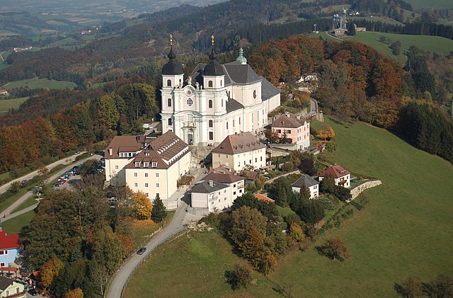

Sonntagberg
- municipality in Austria
Hiking in Sonntagberg
Sonntagberg, located in Austria's Lower Austria region, is a charming destination for hiking enthusiasts. The area is known for its picturesque landscapes, rolling hills, and panoramic views, making it an excellent spot for both casual walkers and more experienced hikers....
- Country:
- Postal Code: 3333
- Local Dialing Code: 07448
- Licence Plate Code: AM
- Coordinates: 47° 59' 46" N, 14° 45' 44" E
- GPS tracks (wikiloc): [Link]
- AboveSeaLevel: 712 м m
- Area: 18.42 sq km
- Population: 3829
- Web site: [Link]
Ertl, Lower Austria
- municipality in Austria
Hiking in Ertl, Lower Austria
Ertl is a small municipality in Lower Austria, known for its beautiful natural landscapes, rolling hills, and charming rural settings. Hiking in the Ertl area offers a great opportunity to explore scenic trails, breathe in fresh air, and enjoy the rich flora and fauna of the region....
- Country:
- Postal Code: 3355
- Local Dialing Code: 07477
- Licence Plate Code: AM
- Coordinates: 47° 58' 36" N, 14° 37' 50" E
- GPS tracks (wikiloc): [Link]
- AboveSeaLevel: 440 м m
- Area: 21.13 sq km
- Population: 1252
- Web site: [Link]
Ennsdorf
- municipality in Austria
Hiking in Ennsdorf
Ennsdorf, located near the Enns River in Austria, is surrounded by beautiful natural landscapes that make it an excellent destination for hiking enthusiasts. Here are some highlights and tips for hiking in and around Ennsdorf:...
- Country:
- Postal Code: 4482
- Local Dialing Code: 07223
- Licence Plate Code: AM
- Coordinates: 48° 12' 45" N, 14° 29' 21" E
- GPS tracks (wikiloc): [Link]
- AboveSeaLevel: 250 м m
- Area: 7.69 sq km
- Population: 3031
- Web site: [Link]
Shares border with regions:

Scheibbs District
- district of Austria
Hiking in Scheibbs District
Scheibbs District, located in the Lower Austria region of Austria, is known for its beautiful landscapes, rich cultural heritage, and a variety of hiking opportunities. Here are some highlights for hiking in this area:...
- Country:
- Licence Plate Code: SB
- Coordinates: 48° 0' 40" N, 15° 5' 20" E
- GPS tracks (wikiloc): [Link]
- AboveSeaLevel: 463 м m
- Area: 1023 sq km
- Web site: [Link]
Melk District
- district of Austria
Hiking in Melk District
The Melk District, located in Lower Austria, is an excellent destination for hiking enthusiasts. This region is characterized by its scenic landscapes, rich history, and diverse trails suitable for various skill levels. Here are some highlights about hiking in the Melk District:...
- Country:
- Licence Plate Code: ME
- Coordinates: 48° 12' 0" N, 15° 12' 14" E
- GPS tracks (wikiloc): [Link]
- AboveSeaLevel: 220 м m
- Area: 1013.62 sq km
- Web site: [Link]