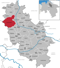
Holste (Holste)
- municipality of Germany
Holste, located in various parts of the world, might refer to a specific region, or it could be a misspelling or abbreviation. Assuming you are referring to hiking in a general region or area named Holste, here's a general overview of what you might expect in such a location based on typical hiking terrains.
If Holste is a rural or mountainous area, here are some features you might encounter:
-
Trails: Look for well-marked trails suitable for various difficulty levels, from easy walks to challenging hikes. Local hiking organizations often maintain maps and provide information about trail conditions.
-
Scenic Views: Many hiking trails lead to beautiful vistas, whether they be mountains, forests, lakes, or valleys. Pay attention to lookout points along the trails.
-
Wildlife: You can often see a variety of wildlife. Remember to respect nature and observe animals from a distance.
-
Flora: Depending on the season, you may encounter diverse plant life, including wildflowers in spring and lush foliage in summer.
-
Safety: Make sure to check weather conditions, carry proper gear, and inform someone about your hiking plans.
-
Amenities: Some areas may have picnic spots, rest areas, or visitor centers with information useful for hikers.
If you have a specific Holste or a particular location in mind, please provide more details so I can give you tailored information!
- Country:

- Postal Code: 27729
- Local Dialing Code: 04748
- Licence Plate Code: OHZ
- Coordinates: 53° 22' 0" N, 8° 49' 59" E


- GPS tracks (wikiloc): [Link]
- AboveSeaLevel: 27 м m
- Area: 35.37 sq km
- Population: 1365
- Web site: http://www.holste.de/
- Wikipedia en: wiki(en)
- Wikipedia: wiki(de)
- Wikidata storage: Wikidata: Q637067
- Wikipedia Commons Category: [Link]
- Freebase ID: [/m/02rzc7j]
- Freebase ID: [/m/02rzc7j]
- Freebase ID: [/m/02rzc7j]
- GeoNames ID: Alt: [2900273]
- GeoNames ID: Alt: [2900273]
- GeoNames ID: Alt: [2900273]
- OSM relation ID: [904474]
- OSM relation ID: [904474]
- OSM relation ID: [904474]
- German municipality key: 03356004
- German municipality key: 03356004
- German municipality key: 03356004
Shares border with regions:


Axstedt
- municipality of Germany
Axstedt is a small municipality in Lower Saxony, Germany, located near the larger town of Ottersberg. While it may not be a well-known hiking destination, it offers opportunities for enjoying nature and exploring the surrounding countryside....
- Country:

- Postal Code: 27729
- Local Dialing Code: 04748
- Licence Plate Code: OHZ
- Coordinates: 53° 21' 0" N, 8° 46' 0" E


- GPS tracks (wikiloc): [Link]
- AboveSeaLevel: 24 м m
- Area: 10.74 sq km
- Population: 1161
- Web site: [Link]


Gnarrenburg
- municipality of Germany
Gnarrenburg, located in Lower Saxony, Germany, is a quaint village surrounded by beautiful countryside, offering opportunities for hiking enthusiasts. The area features scenic trails that wind through forests, fields, and near water bodies, making it ideal for nature lovers....
- Country:

- Postal Code: 27442
- Local Dialing Code: 04763
- Licence Plate Code: ROW
- Coordinates: 53° 23' 0" N, 9° 0' 0" E


- GPS tracks (wikiloc): [Link]
- AboveSeaLevel: 10 м m
- Area: 123.23 sq km
- Population: 9222
- Web site: [Link]


Beverstedt
- municipality in Lower Saxony, Germany
Beverstedt, a picturesque town located in Lower Saxony, Germany, offers various opportunities for hiking enthusiasts. While it may not be as widely known as some larger hiking destinations, its surrounding natural landscapes provide a serene environment for outdoor activities....
- Country:

- Postal Code: 27432; 27616
- Local Dialing Code: 04747
- Licence Plate Code: CUX
- Coordinates: 53° 26' 3" N, 8° 49' 9" E


- GPS tracks (wikiloc): [Link]
- AboveSeaLevel: 12 м m
- Area: 197.6 sq km
- Population: 13526
- Web site: [Link]


Vollersode
- municipality of Germany
Vollersode is a tranquil village located in Lower Saxony, Germany, offering a delightful setting for hiking enthusiasts. The region is characterized by its picturesque landscapes, lush green countryside, and well-marked trails that weave through forests, fields, and along rivers....
- Country:

- Postal Code: 27729
- Local Dialing Code: 04793
- Licence Plate Code: OHZ
- Coordinates: 53° 20' 0" N, 8° 55' 0" E


- GPS tracks (wikiloc): [Link]
- AboveSeaLevel: 20 м m
- Area: 46.37 sq km
- Population: 2813
- Web site: [Link]
Hambergen
- municipality of Germany
Hambergen is a small town in the district of Rotenburg (Wümme) in Lower Saxony, Germany. While it may not be as well-known as some larger hiking destinations, it offers charming landscapes and a peaceful environment perfect for hiking enthusiasts looking for a quieter experience....
- Country:

- Postal Code: 27729
- Local Dialing Code: 04793
- Licence Plate Code: OHZ
- Coordinates: 53° 19' 0" N, 8° 49' 0" E


- GPS tracks (wikiloc): [Link]
- AboveSeaLevel: 27 м m
- Area: 30 sq km
- Population: 5700
- Web site: [Link]


Lübberstedt
- municipality of Germany
Lübberstedt is a small village located in Germany, specifically in the state of Lower Saxony. While it may not be a prominent hiking destination, there are opportunities for outdoor activities in the surrounding areas. Here are a few considerations for hiking near Lübberstedt:...
- Country:

- Postal Code: 27729
- Local Dialing Code: 04793
- Licence Plate Code: OHZ
- Coordinates: 53° 20' 0" N, 8° 48' 0" E


- GPS tracks (wikiloc): [Link]
- AboveSeaLevel: 14 м m
- Area: 12.32 sq km
- Population: 739
- Web site: [Link]

