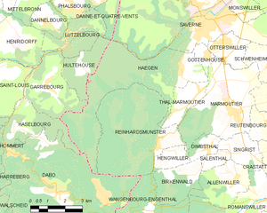
Hultehouse (Hultehouse)

- commune in Moselle, France
- Country:

- Postal Code: 57820
- Coordinates: 48° 43' 10" N, 7° 15' 39" E


- GPS tracks (wikiloc): [Link]
- Area: 4.58 sq km
- Population: 360
- Wikipedia en: wiki(en)
- Wikipedia: wiki(fr)
- Wikidata storage: Wikidata: Q22080
- Wikipedia Commons Category: [Link]
- Freebase ID: [/m/03qdynr]
- Freebase ID: [/m/03qdynr]
- GeoNames ID: Alt: [6437608]
- GeoNames ID: Alt: [6437608]
- SIREN number: [215703398]
- SIREN number: [215703398]
- BnF ID: [15265845t]
- BnF ID: [15265845t]
- VIAF ID: Alt: [239237340]
- VIAF ID: Alt: [239237340]
- INSEE municipality code: 57339
- INSEE municipality code: 57339
Shares border with regions:

Haegen
- commune in Bas-Rhin, France
- Country:
- Postal Code: 67700
- Coordinates: 48° 42' 51" N, 7° 20' 21" E
- GPS tracks (wikiloc): [Link]
- Area: 20.32 sq km
- Population: 689


Danne-et-Quatre-Vents
- commune in Moselle, France
- Country:
- Postal Code: 57370
- Coordinates: 48° 46' 0" N, 7° 17' 41" E
- GPS tracks (wikiloc): [Link]
- Area: 7.2 sq km
- Population: 674
- Web site: [Link]


Garrebourg
- commune in Moselle, France
- Country:
- Postal Code: 57820
- Coordinates: 48° 42' 40" N, 7° 13' 59" E
- GPS tracks (wikiloc): [Link]
- Area: 8.34 sq km
- Population: 497

Lutzelbourg
- commune in Moselle, France
- Country:
- Postal Code: 57820
- Coordinates: 48° 44' 4" N, 7° 15' 5" E
- GPS tracks (wikiloc): [Link]
- Area: 5.84 sq km
- Population: 610