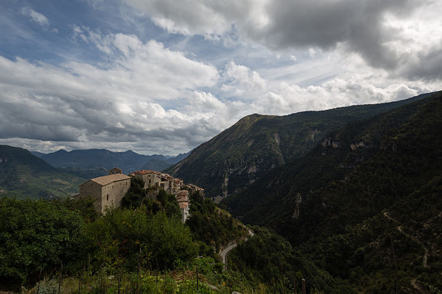
Ilonse (Ilonse)

- commune in Alpes-Maritimes, France
 Hiking in Ilonse
Ilonse is a small village in the Alpes-Maritimes department of southeastern France. It's located near the French Riviera and surrounded by beautiful landscapes, making it an interesting destination for hikers. Here are some details about hiking in and around Ilonse:
Natural Scenery
- Diverse Landscapes: The area around Ilonse features varied terrain, including hills, valleys, and forests. You can enjoy views of the Mediterranean and the surrounding mountains.
- Flora and Fauna: The region is rich in biodiversity, with many native plants and wildlife, making it a great spot for nature enthusiasts.
Hiking Trails
- Local Trails: There are several trails that you can find around Ilonse, suitable for various skill levels. Some trails might lead you through scenic spots with panoramic views, whereas others may take you through tranquil forested areas.
- GR (Grande Randonnée) Routes: The GR trails, which are long-distance hiking routes across France, are also accessible from the region. These trails can provide longer hiking options for those looking for adventure.
Tips for Hiking in Ilonse
- Seasonal Considerations: The best times to hike in this area are spring and autumn when the weather is pleasant, and the landscapes are especially beautiful. Summer can be hot, and winter conditions may limit access to higher trails.
- Gear Up: Make sure you have appropriate hiking gear, including sturdy shoes, water, snacks, and a map or GPS device.
- Weather Awareness: Always check the weather forecast before heading out, as conditions can change unexpectedly, especially in mountainous areas.
Local Attractions
- Cultural Sites: After a hike, you may want to explore the local culture, including visiting churches, historical sites, or enjoying local cuisine in the village.
- Proximity to Other Hikes: Ilonse is not far from other notable hiking areas in the Alpes-Maritimes, such as the Mercantour National Park, which offers extensive hiking opportunities.
Whether you’re a beginner or an experienced hiker, Ilonse can provide a lovely setting for a day of exploration in nature. Remember to respect the environment and follow local guidelines while hiking.
- Country:

- Postal Code: 06420
- Coordinates: 44° 1' 56" N, 7° 5' 58" E


- GPS tracks (wikiloc): [Link]
- Area: 40.59 sq km
- Population: 194
- Web site: http://www.ilonse.fr
- Wikipedia en: wiki(en)
- Wikipedia: wiki(fr)
- Wikidata storage: Wikidata: Q1018188
- Wikipedia Commons Category: [Link]
- GeoNames ID: Alt: [3012828]
- GeoNames ID: Alt: [3012828]
- SIREN number: [210600722]
- SIREN number: [210600722]
- BnF ID: [156084018]
- BnF ID: [156084018]
- WOEID: [595176]
- WOEID: [595176]
- INSEE municipality code: 06072
- INSEE municipality code: 06072
Shares border with regions:


Valdeblore
- commune in Alpes-Maritimes, France
Hiking in Valdeblore
Valdeblore is a beautiful valley located in the French Alps, in the Alpes-Maritimes department of the Provence-Alpes-Côte d'Azur region. It's known for its stunning landscapes, diverse flora and fauna, and excellent hiking opportunities. Here are some key points about hiking in Valdeblore:...
- Country:
- Postal Code: 06420
- Coordinates: 44° 4' 15" N, 7° 10' 16" E
- GPS tracks (wikiloc): [Link]
- AboveSeaLevel: 1050 м m
- Area: 94.16 sq km
- Population: 848
- Web site: [Link]


Roure
- commune in Alpes-Maritimes, France
Hiking in Roure
Roure, located in the Piedmont region of Italy, is a fantastic destination for hiking enthusiasts. Nestled within the stunning natural beauty of the Alps, this area offers a variety of trails that cater to all experience levels. Here are some key points to consider when hiking in Roure:...
- Country:
- Postal Code: 06420
- Coordinates: 44° 5' 25" N, 7° 5' 17" E
- GPS tracks (wikiloc): [Link]
- Area: 40.3 sq km
- Population: 202

Rimplas
- commune in Alpes-Maritimes, France
Hiking in Rimplas
Rimplas is a charming village located in the French Alps, specifically in the Alpes-Maritimes department. This scenic area offers a variety of hiking opportunities for both novice and experienced hikers, with trails that boast stunning views, diverse landscapes, and a connection to nature....
- Country:
- Postal Code: 06420
- Coordinates: 44° 3' 49" N, 7° 7' 48" E
- GPS tracks (wikiloc): [Link]
- Area: 24.95 sq km
- Population: 108


Lieuche
- commune in Alpes-Maritimes, France
Hiking in Lieuche
Lieuche, a charming village located in the Alpes-Maritimes department in the Provence-Alpes-Côte d'Azur region of France, offers a range of hiking opportunities for both beginners and experienced hikers. The natural beauty of the surrounding landscape, characterized by rolling hills, lush forests, and stunning views of the nearby mountains, makes it a wonderful destination for outdoor enthusiasts....
- Country:
- Postal Code: 06260
- Coordinates: 43° 59' 47" N, 7° 1' 1" E
- GPS tracks (wikiloc): [Link]
- Area: 13.4 sq km
- Population: 44


Thiéry
- commune in Alpes-Maritimes, France
Hiking in Thiéry
Thiéry is a picturesque village located in the Alpes-Maritimes department of the Provence-Alpes-Côte d'Azur region in France. Nestled in the foothills of the French Alps, it offers a range of hiking opportunities with stunning views and diverse landscapes....
- Country:
- Postal Code: 06710
- Coordinates: 43° 58' 42" N, 7° 1' 50" E
- GPS tracks (wikiloc): [Link]
- Area: 22.24 sq km
- Population: 104


Villars-sur-Var
- commune in Alpes-Maritimes, France
Hiking in Villars-sur-Var
Villars-sur-Var is a picturesque village located in the Alpes-Maritimes region of southeastern France, nestled within the stunning landscapes of the French Riviera. It's a less-traveled destination compared to its neighboring tourist hotspots, which makes it a great choice for hikers looking for tranquility and natural beauty....
- Country:
- Postal Code: 06710
- Coordinates: 43° 56' 14" N, 7° 5' 50" E
- GPS tracks (wikiloc): [Link]
- Area: 25.27 sq km
- Population: 726
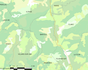
Bairols
- commune in Alpes-Maritimes, France
Hiking in Bairols
Bairols is a charming village situated in the Alpes-Maritimes region of the French Riviera, and it offers a range of beautiful hiking opportunities for both novice and experienced hikers. Nestled in the countryside, it provides stunning views of the surrounding mountains and valleys....
- Country:
- Postal Code: 06420
- Coordinates: 43° 58' 53" N, 7° 7' 38" E
- GPS tracks (wikiloc): [Link]
- Area: 15.24 sq km
- Population: 105


Saint-Sauveur-sur-Tinée
- commune in Alpes-Maritimes, France
Hiking in Saint-Sauveur-sur-Tinée
Saint-Sauveur-sur-Tinée is a picturesque village located in the Alpes-Maritimes department of southeastern France. It offers an excellent setting for hiking enthusiasts, with its stunning natural landscapes, varied terrain, and a range of trails suitable for different skill levels....
- Country:
- Postal Code: 06420
- Coordinates: 44° 5' 2" N, 7° 6' 18" E
- GPS tracks (wikiloc): [Link]
- Area: 32.28 sq km
- Population: 338

Roubion
- commune in Alpes-Maritimes, France
Hiking in Roubion
Roubion is a charming village located in the Alpes-Maritimes region of southeastern France. Surrounded by stunning natural landscapes, it offers a wealth of hiking opportunities for outdoor enthusiasts. Here are some highlights and tips for hiking in and around Roubion:...
- Country:
- Postal Code: 06420
- Coordinates: 44° 5' 34" N, 7° 3' 2" E
- GPS tracks (wikiloc): [Link]
- Area: 27.26 sq km
- Population: 118


Marie
- commune in Alpes-Maritimes, France
Hiking in Marie
Marie, situated in the Alpes-Maritimes region of France, offers a range of hiking opportunities that showcase the stunning natural beauty of the French Riviera and the surrounding Alpine landscapes. The area is characterized by diverse terrains, including mountains, valleys, and coastal views, making it ideal for hikers of varying skill levels....
- Country:
- Postal Code: 06420
- Coordinates: 44° 1' 55" N, 7° 8' 4" E
- GPS tracks (wikiloc): [Link]
- Area: 14.77 sq km
- Population: 107

Pierlas
- commune in Alpes-Maritimes, France
Hiking in Pierlas
Pierlas is a charming village located in the Alpes-Maritimes department of France, nestled in the scenic region of Provence-Alpes-Côte d'Azur. It's a great place for hiking enthusiasts looking to explore nature and enjoy breathtaking views of the surrounding mountains and valleys....
- Country:
- Postal Code: 06260
- Coordinates: 44° 1' 54" N, 7° 2' 8" E
- GPS tracks (wikiloc): [Link]
- Area: 31.31 sq km
- Population: 97