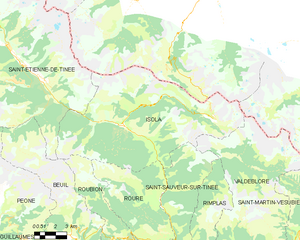
Saint-Sauveur-sur-Tinée (Saint-Sauveur-sur-Tinée)

- commune in Alpes-Maritimes, France
 Hiking in Saint-Sauveur-sur-Tinée
Saint-Sauveur-sur-Tinée is a picturesque village located in the Alpes-Maritimes department of southeastern France. It offers an excellent setting for hiking enthusiasts, with its stunning natural landscapes, varied terrain, and a range of trails suitable for different skill levels.
Hiking Trails and Areas
-
Trail to Le Caire: This is a popular hike that offers beautiful views of the Tinée Valley. The trail is well-marked, making it accessible for families and novice hikers.
-
Mont Mounier: For those seeking a more challenging adventure, the hike to Mont Mounier is a rewarding challenge. The summit offers panoramic views of the surrounding mountains and valleys.
-
Gorges de la Tinée: An exciting area for hiking, the Gorges de la Tinée features dramatic cliffs and rushing waters. Various trails weave through the area, providing opportunities for both casual walks and more strenuous hikes.
-
Paths of the Mercantour National Park: The nearby Mercantour National Park, one of France's stunning national parks, is a treasure trove of hiking opportunities, including routes leading to glacial lakes, mountain passes, and wildlife viewing.
Tips for Hiking in Saint-Sauveur-sur-Tinée
- Plan Ahead: Before heading out, check weather conditions and trail statuses, as some trails may be affected by seasonal changes.
- Equipment: Wear appropriate hiking shoes and bring essentials like water, snacks, a map, and a first-aid kit.
- Respect the Environment: Follow Leave No Trace principles, including staying on marked trails and packing out all trash.
- Wildlife Awareness: Be aware of the diverse wildlife in the region and maintain a respectful distance from any animals you may encounter.
Local Amenities
After a day of hiking, you may want to enjoy the local cuisine in Saint-Sauveur-sur-Tinée. The village has several restaurants and cafes where you can savor traditional dishes and recharge for your next hiking adventure.
Overall, hiking in Saint-Sauveur-sur-Tinée is a wonderful way to experience the breathtaking beauty of the French Alps while enjoying outdoor activities. Whether you're a beginner or an experienced hiker, this area offers trails that cater to all levels of fitness and adventure.
- Country:

- Postal Code: 06420
- Coordinates: 44° 5' 2" N, 7° 6' 18" E


- GPS tracks (wikiloc): [Link]
- Area: 32.28 sq km
- Population: 338
- Wikipedia en: wiki(en)
- Wikipedia: wiki(fr)
- Wikidata storage: Wikidata: Q856193
- Wikipedia Commons Category: [Link]
- SIREN number: [210601290]
- SIREN number: [210601290]
- VIAF ID: Alt: [157147139]
- VIAF ID: Alt: [157147139]
- Library of Congress authority ID: Alt: [n83193912]
- Library of Congress authority ID: Alt: [n83193912]
- INSEE municipality code: 06129
- INSEE municipality code: 06129
Shares border with regions:


Ilonse
- commune in Alpes-Maritimes, France
Hiking in Ilonse
Ilonse is a small village in the Alpes-Maritimes department of southeastern France. It's located near the French Riviera and surrounded by beautiful landscapes, making it an interesting destination for hikers. Here are some details about hiking in and around Ilonse:...
- Country:
- Postal Code: 06420
- Coordinates: 44° 1' 56" N, 7° 5' 58" E
- GPS tracks (wikiloc): [Link]
- Area: 40.59 sq km
- Population: 194
- Web site: [Link]


Valdeblore
- commune in Alpes-Maritimes, France
Hiking in Valdeblore
Valdeblore is a beautiful valley located in the French Alps, in the Alpes-Maritimes department of the Provence-Alpes-Côte d'Azur region. It's known for its stunning landscapes, diverse flora and fauna, and excellent hiking opportunities. Here are some key points about hiking in Valdeblore:...
- Country:
- Postal Code: 06420
- Coordinates: 44° 4' 15" N, 7° 10' 16" E
- GPS tracks (wikiloc): [Link]
- AboveSeaLevel: 1050 м m
- Area: 94.16 sq km
- Population: 848
- Web site: [Link]


Roure
- commune in Alpes-Maritimes, France
Hiking in Roure
Roure, located in the Piedmont region of Italy, is a fantastic destination for hiking enthusiasts. Nestled within the stunning natural beauty of the Alps, this area offers a variety of trails that cater to all experience levels. Here are some key points to consider when hiking in Roure:...
- Country:
- Postal Code: 06420
- Coordinates: 44° 5' 25" N, 7° 5' 17" E
- GPS tracks (wikiloc): [Link]
- Area: 40.3 sq km
- Population: 202

Isola
- commune in Alpes-Maritimes, France
Hiking in Isola
Isola is a charming village located in the Alpes-Maritimes region of France, renowned for its stunning natural landscapes and outdoor activities, especially hiking. Situated in the heart of the Southern Alps, Isola offers a variety of trails that cater to different skill levels, from leisurely walks to more challenging hikes....
- Country:
- Postal Code: 06420
- Coordinates: 44° 11' 9" N, 7° 3' 8" E
- GPS tracks (wikiloc): [Link]
- Area: 97.98 sq km
- Population: 693

Rimplas
- commune in Alpes-Maritimes, France
Hiking in Rimplas
Rimplas is a charming village located in the French Alps, specifically in the Alpes-Maritimes department. This scenic area offers a variety of hiking opportunities for both novice and experienced hikers, with trails that boast stunning views, diverse landscapes, and a connection to nature....
- Country:
- Postal Code: 06420
- Coordinates: 44° 3' 49" N, 7° 7' 48" E
- GPS tracks (wikiloc): [Link]
- Area: 24.95 sq km
- Population: 108