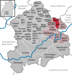
Irndorf (Irndorf)
- municipality in Germany
Irndorf is a small village located in the rural heart of Germany, known for its beautiful landscapes and serene environments that attract hikers and outdoor enthusiasts. While it may not be as well-known as larger hiking destinations, it offers a unique experience for those looking to explore the natural beauty of the region.
Hiking Trails
The area around Irndorf features various hiking trails, ranging from easy walks suitable for families to more challenging routes for seasoned hikers. You can expect to encounter scenic views, rolling hills, and lush greenery. Look for well-marked trails that may lead you through forests, meadows, and beside rivers or streams.
Points of Interest
- Natural Landscapes: The countryside offers picturesque views, ideal for photography and relaxation in nature.
- Wildlife: Keep an eye out for local wildlife, including birds and small mammals, which thrive in the area's diverse habitats.
- Cultural Sites: Depending on the trails you choose, you might come across historical landmarks or traditional German architecture.
Tips for Hiking in Irndorf
- Weather Preparedness: Always check the weather forecast before you head out, as conditions can change rapidly in the outdoors.
- Proper Footwear: Wear sturdy hiking boots that provide good support to navigate the varied terrain.
- Pack Essentials: Bring water, snacks, a first aid kit, and a map or compass. A fully charged mobile device with a GPS application is also advisable.
- Respect Nature: Follow local guidelines for taking care of nature. Stay on marked trails and carry out any trash you might generate.
Best Time to Visit
Spring and fall are ideal for hiking in the area, as temperatures are moderate, and the scenery is vibrant with blooming flowers in spring and stunning foliage in fall. Summer can be hot, while winter may bring snow, affecting trail accessibility.
Conclusion
Irndorf may not be a major hiking hub, but its tranquil surroundings and natural beauty make it a perfect spot for a peaceful hiking experience. Whether you're a beginner or an experienced hiker, you'll find a welcoming atmosphere and the opportunity to connect with nature. Always remember to prepare accordingly to ensure a safe and enjoyable hike!
- Country:

- Postal Code: 78597
- Local Dialing Code: 07466
- Licence Plate Code: TUT
- Coordinates: 48° 4' 0" N, 8° 58' 0" E


- GPS tracks (wikiloc): [Link]
- AboveSeaLevel: 838 м m
- Area: 14.56 sq km
- Population: 689
- Web site: http://www.irndorf.de
- Wikipedia en: wiki(en)
- Wikipedia: wiki(de)
- Wikidata storage: Wikidata: Q529267
- Wikipedia Commons Category: [Link]
- Freebase ID: [/m/02q03mt]
- GeoNames ID: Alt: [6555845]
- VIAF ID: Alt: [233747933]
- OSM relation ID: [1231976]
- GND ID: Alt: [4202217-4]
- Historical Gazetteer (GOV) ID: [IRNORFJN48LB]
- German municipality key: 08327027
Shares border with regions:


Bärenthal
- municipality in Germany
Bärenthal, located in the scenic region of Baden-Württemberg, Germany, offers several hiking opportunities that cater to different skill levels amidst beautiful landscapes. The area is characterized by its rolling hills, dense forests, and picturesque villages, making it a great destination for outdoor enthusiasts....
- Country:

- Postal Code: 78580
- Local Dialing Code: 07466
- Licence Plate Code: TUT
- Coordinates: 48° 4' 25" N, 8° 55' 40" E


- GPS tracks (wikiloc): [Link]
- AboveSeaLevel: 778 м m
- Area: 12.69 sq km
- Population: 467
- Web site: [Link]


Beuron
- municipality in Germany
Beuron is a picturesque village located in the Swabian Jura region of Germany, renowned for its stunning natural landscapes, rich history, and opportunities for hiking. Nestled along the banks of the Danube River, Beuron serves as an excellent starting point for various hiking trails that cater to different skill levels. Here are some key points about hiking in Beuron:...
- Country:

- Postal Code: 88631
- Local Dialing Code: 07579
- Licence Plate Code: SIG
- Coordinates: 48° 3' 0" N, 8° 58' 0" E


- GPS tracks (wikiloc): [Link]
- AboveSeaLevel: 609 м m
- Area: 35.1 sq km
- Population: 642
- Web site: [Link]

