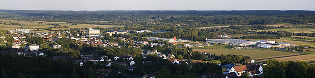
Jennersdorf District (Bezirk Jennersdorf)

- district of Austria
 Hiking in Jennersdorf District
Jennersdorf District, located in the southern part of Austria, is known for its beautiful landscapes and hiking opportunities. Nestled in the province of Burgenland, this area features a mix of rolling hills, vineyards, and serene countryside, making it a great destination for both seasoned hikers and casual walkers.
Hiking Trails and Areas
-
Thermal Region: The area is known for its thermal springs, and many hiking trails lead to or through these naturally beautiful spots. You can enjoy the calming nature while also being close to facilities for relaxation.
-
Puszta and Vineyards: The surrounding countryside, particularly the vineyards, offers a unique landscape for hiking. Trails often wind through vine-covered hills, providing picturesque views. Look for trails that connect the local wine-producing estates.
-
Nature Reserves: Jennersdorf is near several protected areas and nature reserves that offer well-marked trails. The diverse flora and fauna in these regions provide excellent birdwatching opportunities and chances to learn about local ecosystems.
-
Hiking with Themes: There are thematic hiking trails, such as those that focus on local history or nature education. These trails often have boards and markers that inform hikers about the area’s cultural and natural significance.
Tips for Hiking in Jennersdorf District
-
Seasonal Considerations: Spring and fall are ideal seasons for hiking, with mild temperatures and gorgeous changing foliage. Summer can be quite hot, so consider early morning hikes to avoid the heat.
-
Local Resources: Visit the local tourism office for maps and additional information on current trail conditions and guided hikes.
-
Respect Nature: As always, practice Leave No Trace principles. Stay on marked trails, and be mindful of wildlife.
-
Hydration and Snacks: Carry enough water and snacks, especially on longer hikes, as facilities may be limited on some trails.
-
Dress Appropriately: Wear proper hiking shoes and dress in layers to accommodate changes in temperature throughout the day.
Exploring the hiking trails in the Jennersdorf District offers a great way to enjoy the natural beauty of Austria while experiencing the local culture and history. Happy hiking!
- Country:

- Capital: Jennersdorf
- Licence Plate Code: JE
- Coordinates: 46° 56' 53" N, 16° 8' 24" E


- GPS tracks (wikiloc): [Link]
- AboveSeaLevel: 331 м m
- Area: 253 sq km
- Population: 17289
- Wikipedia en: wiki(en)
- Wikipedia: wiki(de)
- Wikidata storage: Wikidata: Q756277
- Wikipedia Commons Category: [Link]
- Freebase ID: [/m/06vns9]
- GeoNames ID: Alt: [2775088]
- VIAF ID: Alt: [237474572]
- archINFORM location ID: [14661]
Includes regions:

Deutsch Kaltenbrunn
- municipality in Austria
Hiking in Deutsch Kaltenbrunn
Deutsch Kaltenbrunn is a picturesque village in the state of Bavaria, Germany, situated near the border with Austria. It’s a great location for hiking enthusiasts, offering a combination of beautiful natural landscapes and well-marked trails. Here are some key highlights to consider if you’re planning a hiking trip to this area:...
- Country:
- Postal Code: 7572
- Local Dialing Code: 03382
- Licence Plate Code: JE
- Coordinates: 47° 5' 24" N, 16° 6' 24" E
- GPS tracks (wikiloc): [Link]
- AboveSeaLevel: 262 м m
- Area: 24.19 sq km
- Population: 1721
- Web site: [Link]

Weichselbaum
- municipality in Austria
Hiking in Weichselbaum
Weichselbaum is a small village located in Styria, Austria, known for its picturesque landscapes and beautiful natural surroundings, making it a pleasant destination for hiking enthusiasts. Here are some details about hiking in the area:...
- Country:
- Postal Code: 8382
- Local Dialing Code: 03329
- Licence Plate Code: JE
- Coordinates: 46° 56' 38" N, 16° 11' 8" E
- GPS tracks (wikiloc): [Link]
- AboveSeaLevel: 239 м m
- Area: 12.17 sq km
- Population: 720
- Web site: [Link]
Jennersdorf
- municipality in Austria
Hiking in Jennersdorf
Jennersdorf, located in Burgenland, Austria, is a picturesque area that offers a range of beautiful hiking trails suited for various skill levels. The region is characterized by rolling hills, vineyards, and lush greenery, making it a wonderful destination for nature lovers and outdoor enthusiasts....
- Country:
- Postal Code: 8380
- Local Dialing Code: 03329
- Licence Plate Code: JE
- Coordinates: 46° 56' 16" N, 16° 8' 24" E
- GPS tracks (wikiloc): [Link]
- AboveSeaLevel: 242 м m
- Area: 37.92 sq km
- Population: 4096
- Web site: [Link]

Mogersdorf
- municipality in Austria
Hiking in Mogersdorf
Mogersdorf, located in the picturesque region of Austria, offers a variety of hiking opportunities for nature enthusiasts and outdoor adventurers alike. Nestled in the scenic landscape of Styria, the area is characterized by rolling hills, vineyards, and tranquil forests. Here are some key points to consider when hiking in Mogersdorf:...
- Country:
- Postal Code: 8382
- Local Dialing Code: 03325
- Licence Plate Code: JE
- Coordinates: 46° 56' 55" N, 16° 13' 57" E
- GPS tracks (wikiloc): [Link]
- AboveSeaLevel: 228 м m
- Area: 12.8 sq km
- Population: 1164
- Web site: [Link]


Sankt Martin an der Raab
- municipality in Austria
Hiking in Sankt Martin an der Raab
Sankt Martin an der Raab is a picturesque village located in the Burgenland region of Austria, known for its serene landscapes and the gentle rolling hills that surround it. It offers a variety of hiking opportunities that cater to all levels, making it an appealing destination for outdoor enthusiasts....
- Country:
- Local Dialing Code: 03329
- Licence Plate Code: JE
- Coordinates: 46° 55' 14" N, 16° 8' 4" E
- GPS tracks (wikiloc): [Link]
- AboveSeaLevel: 250 м m
- Area: 43 sq km
- Population: 1959
- Web site: [Link]

Rudersdorf
- municipality in Austria
Hiking in Rudersdorf
Rudersdorf, a charming area in Austria, offers various hiking opportunities that showcase its beautiful landscape, historical sites, and natural wonders. While hiking routes can vary from easy to challenging, the region is suitable for both beginners and experienced hikers. Here are some highlights of hiking in Rudersdorf:...
- Country:
- Local Dialing Code: 03382
- Licence Plate Code: JE
- Coordinates: 47° 2' 54" N, 16° 7' 20" E
- GPS tracks (wikiloc): [Link]
- AboveSeaLevel: 248 м m
- Area: 21.4 sq km
- Population: 2176
- Web site: [Link]

Heiligenkreuz im Lafnitztal
- municipality in Austria
Hiking in Heiligenkreuz im Lafnitztal
Heiligenkreuz im Lafnitztal is a charming village in Austria's Burgenland region, surrounded by beautiful landscapes that are ideal for hiking enthusiasts. Here are some key points about hiking in this area:...
- Country:
- Postal Code: 7561
- Local Dialing Code: 03325
- Licence Plate Code: JE
- Coordinates: 46° 59' 18" N, 16° 15' 36" E
- GPS tracks (wikiloc): [Link]
- AboveSeaLevel: 243 м m
- Area: 23.8 sq km
- Population: 1231
- Web site: [Link]

Eltendorf
- municipality in Austria
Hiking in Eltendorf
Eltendorf is a small town located in Austria, specifically in the Burgenland region. While it may not be as widely known as some other hiking destinations, it offers access to some beautiful landscapes and nature trails that can be enjoyed by hikers of various skill levels....
- Country:
- Postal Code: 7562
- Local Dialing Code: 03325
- Licence Plate Code: JE
- Coordinates: 47° 0' 32" N, 16° 12' 13" E
- GPS tracks (wikiloc): [Link]
- AboveSeaLevel: 246 м m
- Area: 20.58 sq km
- Population: 954
- Web site: [Link]

Neuhaus am Klausenbach
- municipality in Austria
Hiking in Neuhaus am Klausenbach
Neuhaus am Klausenbach is a picturesque village located in the southern part of Austria, near the borders of Slovenia and Hungary. It is a great place for hiking enthusiasts, as the region boasts a variety of trails that cater to different skill levels and offer stunning natural landscapes....
- Country:
- Postal Code: 8384, 8385
- Local Dialing Code: 03329
- Licence Plate Code: JE
- Coordinates: 46° 52' 5" N, 16° 1' 50" E
- GPS tracks (wikiloc): [Link]
- AboveSeaLevel: 292 м m
- Area: 19.99 sq km
- Population: 921
- Web site: [Link]

Königsdorf
- municipality in Austria
Hiking in Königsdorf
Königsdorf is a picturesque village located in the beautiful landscapes of Austria, surrounded by the stunning scenery of the Alps. Hiking in this region offers a variety of trails suitable for different skill levels, from leisurely walks to more challenging hikes....
- Country:
- Postal Code: 7563
- Local Dialing Code: 03325
- Licence Plate Code: JE
- Coordinates: 47° 0' 15" N, 16° 10' 11" E
- GPS tracks (wikiloc): [Link]
- AboveSeaLevel: 236 м m
- Area: 15.67 sq km
- Population: 720
- Web site: [Link]

Mühlgraben
- municipality in Austria
Hiking in Mühlgraben
Mühlgraben is a picturesque area often appreciated by hikers for its scenic landscapes and outdoor activities. It's located in Austria, nestled in the scenic foothills of the Alps. While specific trails may vary by season and conditions, here are some general highlights of hiking in the Mühlgraben area:...
- Country:
- Postal Code: 8385
- Local Dialing Code: 03329
- Licence Plate Code: JE
- Coordinates: 46° 53' 24" N, 16° 3' 23" E
- GPS tracks (wikiloc): [Link]
- AboveSeaLevel: 318 м m
- Area: 5.5 sq km
- Population: 396
- Web site: [Link]

Minihof-Liebau
- municipality in Austria
Hiking in Minihof-Liebau
Minihof-Liebau is a charming village located in the southern part of Austria, in the state of Styria. This area is surrounded by picturesque landscapes, rolling hills, and lush forests, making it an ideal location for hiking enthusiasts. Here are some aspects to consider when hiking in Minihof-Liebau:...
- Country:
- Postal Code: 8384
- Local Dialing Code: 03329
- Licence Plate Code: JE
- Coordinates: 46° 52' 57" N, 16° 4' 13" E
- GPS tracks (wikiloc): [Link]
- AboveSeaLevel: 285 м m
- Area: 16.3 sq km
- Population: 1054
- Web site: [Link]
Shares border with regions:

Hartberg-Fürstenfeld District
- district in Austria
Hiking in Hartberg-Fürstenfeld District
The Hartberg-Fürstenfeld District, located in the Styria region of Austria, offers a variety of hiking opportunities amidst picturesque landscapes. The area is characterized by rolling hills, lush forests, and scenic views of the surrounding mountains, making it an excellent destination for outdoor enthusiasts....
- Country:
- Licence Plate Code: HF
- Coordinates: 47° 16' 0" N, 15° 58' 0" E
- GPS tracks (wikiloc): [Link]
- Area: 1228 sq km
- Web site: [Link]