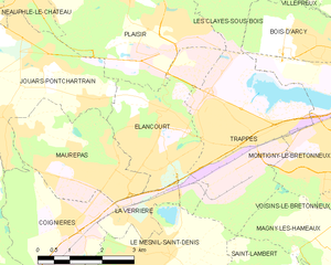
Jouars-Pontchartrain (Jouars-Pontchartrain)

- commune in Yvelines, France
- Country:

- Postal Code: 78760
- Coordinates: 48° 48' 11" N, 1° 54' 5" E


- GPS tracks (wikiloc): [Link]
- Area: 9.65 sq km
- Population: 5476
- Web site: http://www.mairie-jouarspontchartrain.fr
- Wikipedia en: wiki(en)
- Wikipedia: wiki(fr)
- Wikidata storage: Wikidata: Q255198
- Wikipedia Commons Category: [Link]
- Freebase ID: [/m/03qg4q_]
- Freebase ID: [/m/03qg4q_]
- GeoNames ID: Alt: [3012234]
- GeoNames ID: Alt: [3012234]
- SIREN number: [217803212]
- SIREN number: [217803212]
- BnF ID: [15275994h]
- BnF ID: [15275994h]
- VIAF ID: Alt: [144016344]
- VIAF ID: Alt: [144016344]
- GND ID: Alt: [4238975-6]
- GND ID: Alt: [4238975-6]
- PACTOLS thesaurus ID: [pcrtqFkNipwKdO]
- PACTOLS thesaurus ID: [pcrtqFkNipwKdO]
- WOEID: [595613]
- WOEID: [595613]
- SUDOC authorities ID: [030854172]
- SUDOC authorities ID: [030854172]
- INSEE municipality code: 78321
- INSEE municipality code: 78321
Shares border with regions:

Élancourt
- commune in Yvelines, France
- Country:
- Postal Code: 78990
- Coordinates: 48° 46' 6" N, 1° 56' 58" E
- GPS tracks (wikiloc): [Link]
- Area: 8.51 sq km
- Population: 25504
- Web site: [Link]


Plaisir
- commune in Yvelines, France
- Country:
- Postal Code: 78370
- Coordinates: 48° 49' 4" N, 1° 56' 47" E
- GPS tracks (wikiloc): [Link]
- Area: 18.68 sq km
- Population: 31857
- Web site: [Link]


Coignières
- commune in Yvelines, France
- Country:
- Postal Code: 78310
- Coordinates: 48° 44' 50" N, 1° 55' 13" E
- GPS tracks (wikiloc): [Link]
- Area: 8.27 sq km
- Population: 4350
- Web site: [Link]


Neauphle-le-Château
- commune in Yvelines, France
- Country:
- Postal Code: 78640
- Coordinates: 48° 48' 52" N, 1° 54' 8" E
- GPS tracks (wikiloc): [Link]
- Area: 2.15 sq km
- Population: 3214
- Web site: [Link]


Villiers-Saint-Frédéric
- commune in Yvelines, France
- Country:
- Postal Code: 78640
- Coordinates: 48° 49' 15" N, 1° 53' 24" E
- GPS tracks (wikiloc): [Link]
- Area: 5.06 sq km
- Population: 2764
- Web site: [Link]


Neauphle-le-Vieux
- commune in Yvelines, France
- Country:
- Postal Code: 78640
- Coordinates: 48° 48' 57" N, 1° 51' 47" E
- GPS tracks (wikiloc): [Link]
- Area: 7.52 sq km
- Population: 974
- Web site: [Link]

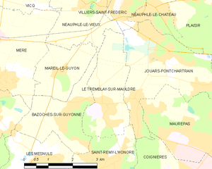
Le Tremblay-sur-Mauldre
- commune in Yvelines, France
- Country:
- Postal Code: 78490
- Coordinates: 48° 46' 39" N, 1° 52' 42" E
- GPS tracks (wikiloc): [Link]
- Area: 6.03 sq km
- Population: 928
- Web site: [Link]


Maurepas
- commune in Yvelines, France
- Country:
- Postal Code: 78310
- Coordinates: 48° 45' 46" N, 1° 56' 44" E
- GPS tracks (wikiloc): [Link]
- Area: 8.32 sq km
- Population: 18840
- Web site: [Link]

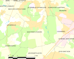
Saint-Rémy-l'Honoré
- commune in Yvelines, France
- Country:
- Postal Code: 78690
- Coordinates: 48° 45' 23" N, 1° 52' 51" E
- GPS tracks (wikiloc): [Link]
- Area: 10.15 sq km
- Population: 1497
- Web site: [Link]