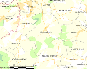
Joudreville (Joudreville)

- commune in Meurthe-et-Moselle, France
- Country:

- Postal Code: 54490
- Coordinates: 49° 17' 8" N, 5° 46' 38" E


- GPS tracks (wikiloc): [Link]
- Area: 5.58 sq km
- Population: 1160
- Wikipedia en: wiki(en)
- Wikipedia: wiki(fr)
- Wikidata storage: Wikidata: Q1060533
- Wikipedia Commons Category: [Link]
- Freebase ID: [/m/03qdjdt]
- Freebase ID: [/m/03qdjdt]
- Freebase ID: [/m/03qdjdt]
- GeoNames ID: Alt: [6436681]
- GeoNames ID: Alt: [6436681]
- GeoNames ID: Alt: [6436681]
- SIREN number: [215402843]
- SIREN number: [215402843]
- SIREN number: [215402843]
- BnF ID: [15264353t]
- BnF ID: [15264353t]
- BnF ID: [15264353t]
- VIAF ID: Alt: [246352954]
- VIAF ID: Alt: [246352954]
- VIAF ID: Alt: [246352954]
- INSEE municipality code: 54284
- INSEE municipality code: 54284
- INSEE municipality code: 54284
Shares border with regions:

Norroy-le-Sec
- commune in Meurthe-et-Moselle, France
- Country:
- Postal Code: 54150
- Coordinates: 49° 16' 48" N, 5° 48' 39" E
- GPS tracks (wikiloc): [Link]
- Area: 13.77 sq km
- Population: 417


Piennes
- commune in Meurthe-et-Moselle, France
- Country:
- Postal Code: 54490
- Coordinates: 49° 18' 24" N, 5° 47' 11" E
- GPS tracks (wikiloc): [Link]
- Area: 4.67 sq km
- Population: 2480


Bouligny
- commune in Meuse, France
- Country:
- Postal Code: 55240
- Coordinates: 49° 17' 30" N, 5° 44' 33" E
- GPS tracks (wikiloc): [Link]
- Area: 10.99 sq km
- Population: 2616
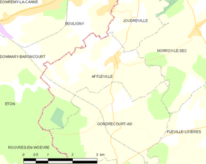
Affléville
- commune in Meurthe-et-Moselle, France
- Country:
- Postal Code: 54800
- Coordinates: 49° 16' 13" N, 5° 45' 48" E
- GPS tracks (wikiloc): [Link]
- Area: 9.42 sq km
- Population: 179