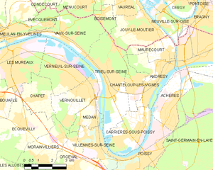
Jouy-le-Moutier (Jouy-le-Moutier)

- commune in Val-d'Oise, France
- Country:

- Postal Code: 95280
- Coordinates: 49° 0' 39" N, 2° 2' 19" E


- GPS tracks (wikiloc): [Link]
- Area: 6.89 sq km
- Population: 15971
- Web site: http://www.jouylemoutier.fr
- Wikipedia en: wiki(en)
- Wikipedia: wiki(fr)
- Wikidata storage: Wikidata: Q1458468
- Wikipedia Commons Category: [Link]
- Freebase ID: [/m/04f217]
- Freebase ID: [/m/04f217]
- GeoNames ID: Alt: [3012162]
- GeoNames ID: Alt: [3012162]
- SIREN number: [219503232]
- SIREN number: [219503232]
- BnF ID: [152804615]
- BnF ID: [152804615]
- VIAF ID: Alt: [144321378]
- VIAF ID: Alt: [144321378]
- GND ID: Alt: [7517037-1]
- GND ID: Alt: [7517037-1]
- Library of Congress authority ID: Alt: [no2002064870]
- Library of Congress authority ID: Alt: [no2002064870]
- PACTOLS thesaurus ID: [pcrtlKw5fTFmOo]
- PACTOLS thesaurus ID: [pcrtlKw5fTFmOo]
- MusicBrainz area ID: [291cb907-c38b-4d60-a0bd-63764bd2abf1]
- MusicBrainz area ID: [291cb907-c38b-4d60-a0bd-63764bd2abf1]
- WOEID: [12643166]
- WOEID: [12643166]
- TGN ID: [1033532]
- TGN ID: [1033532]
- INSEE municipality code: 95323
- INSEE municipality code: 95323
Shares border with regions:


Vauréal
- commune in Val-d'Oise, France
- Country:
- Postal Code: 95490
- Coordinates: 49° 1' 48" N, 2° 1' 17" E
- GPS tracks (wikiloc): [Link]
- Area: 3.46 sq km
- Population: 16221
- Web site: [Link]


Neuville-sur-Oise
- commune in Val-d'Oise, France
- Country:
- Postal Code: 95000
- Coordinates: 49° 0' 54" N, 2° 3' 33" E
- GPS tracks (wikiloc): [Link]
- Area: 4.25 sq km
- Population: 2036
- Web site: [Link]


Boisemont
- commune in Val-d'Oise, France
- Country:
- Postal Code: 95000
- Coordinates: 49° 1' 17" N, 2° 0' 6" E
- GPS tracks (wikiloc): [Link]
- Area: 2.77 sq km
- Population: 769
- Web site: [Link]

Triel-sur-Seine
- commune in Yvelines, France
- Country:
- Postal Code: 78510
- Coordinates: 48° 58' 51" N, 2° 0' 22" E
- GPS tracks (wikiloc): [Link]
- Area: 13.58 sq km
- Population: 11922

Maurecourt
- commune in Yvelines, France
- Country:
- Postal Code: 78780
- Coordinates: 48° 59' 50" N, 2° 3' 43" E
- GPS tracks (wikiloc): [Link]
- Area: 3.65 sq km
- Population: 4422
- Web site: [Link]