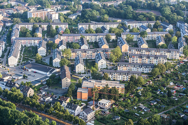
Kalk (Köln-Kalk (Stadtbezirk))

- city district of Cologne No. 8
 Hiking in Kalk
Kalk, a district in Cologne, Germany, is not primarily known for hiking as it is more urbanized compared to the surrounding areas. However, there are several opportunities for walking and exploring the green spaces in and around Kalk.
Local Parks and Green Spaces
-
Flora Park: Located relatively nearby, this beautiful botanical garden offers landscaped areas that make for pleasant strolls and picnics. It's a great spot to relax and enjoy nature.
-
Kalk Park: This park within the district has walking paths and open spaces. It is not extensive, but it provides a nice area for a leisurely walk or a short hike.
-
Rondorf Forest: A bit further from Kalk, you can access trails through wooded areas and natural landscapes. The forest offers a more immersive hiking experience, away from the city's hustle and bustle.
Nearby Hiking Opportunities
-
Wahner Heide: Located approximately 15 km from Kalk, this nature reserve offers various trails through heathland and woodlands, making it suitable for longer hikes.
-
The Rhine River: A bit further out, you can find trails along the Rhine, providing long, scenic walks that showcase beautiful views of the river and surrounding nature.
Tips for Hiking in and Around Kalk
- Plan your route: Use local maps or apps to find walking paths and trails.
- Check the weather: Make sure to dress appropriately for the conditions, especially if you're venturing out into natural areas.
- Stay safe: Always let someone know your plans and carry water and snacks.
While Kalk itself may not be a hiking hotspot, the surrounding areas offer a variety of options for outdoor enthusiasts. Whether you prefer a leisurely walk in the park or a more adventurous hike in nature reserves, you'll find something to enjoy!
- Country:

- Coordinates: 50° 56' 9" N, 7° 1' 7" E


- GPS tracks (wikiloc): [Link]
- Area: 38.2 sq km
- Population: 119055
- Web site: http://www.stadt-koeln.de/leben-in-koeln/stadtbezirke/kalk/kalk
- Wikipedia en: wiki(en)
- Wikipedia: wiki(de)
- Wikidata storage: Wikidata: Q446870
- Wikipedia Commons Gallery: [Link]
- Wikipedia Commons Category: [Link]
- Freebase ID: [/m/04ygbyq]
- GeoNames ID: Alt: [6947480]
- GND ID: Alt: [4806133-5]
- archINFORM location ID: [5121]
Includes regions:

Vingst
- city quarter no. 803 of Cologne, Germany
Hiking in Vingst
Vingst is a district in Cologne, Germany, known for its urban setting rather than traditional hiking trails. However, there are several parks and green areas nearby that offer opportunities for walking and light hiking....
- Country:
- Coordinates: 50° 55' 59" N, 7° 1' 18" E
- GPS tracks (wikiloc): [Link]

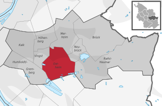
Ostheim
- city quarter no. 805 of Cologne, Germany
Hiking in Ostheim
Ostheim is a district of Cologne (Köln), located in North Rhine-Westphalia, Germany. While the area itself may not be known for extensive hiking trails like more rural regions, there are still some enjoyable options for outdoor activities and shorter hikes in and around the city. Here are a few suggestions for hiking and outdoor exploration near Ostheim:...
- Country:
- Coordinates: 50° 55' 46" N, 7° 2' 27" E
- GPS tracks (wikiloc): [Link]
Höhenberg
- city quarter no. 804 of Cologne, Germany
Hiking in Höhenberg
Höhenberg, located in Köln (Cologne), Germany, is primarily an urban area, so traditional hiking trails may be a bit limited compared to more rural or mountainous regions. However, there are still some great opportunities for walking and enjoying nature in and around the area....
- Country:
- Coordinates: 50° 56' 28" N, 7° 1' 37" E
- GPS tracks (wikiloc): [Link]
Kalk
- city quarter no. 802 of Cologne, Germany, and a subdivision of city district Kalk
Hiking in Kalk
Kalk, located in the eastern part of Cologne (Köln), Germany, is primarily an urban area, but it has several parks and green spaces that can offer enjoyable hiking experiences....
- Country:
- Coordinates: 50° 56' 34" N, 7° 0' 23" E
- GPS tracks (wikiloc): [Link]


Neubrück
- city quarter no. 809 of Cologne, Germany
Hiking in Neubrück
Neubrück is a district located in the city of Köln (Cologne), Germany. While it may not be as renowned for hiking as some of the more mountainous regions in Germany, there are still opportunities for outdoor activities and nature walks in and around the area. Here are some points to consider if you're looking to hike or enjoy outdoor activities near Neubrück:...
- Country:
- Coordinates: 50° 56' 9" N, 7° 3' 35" E
- GPS tracks (wikiloc): [Link]
Humboldt/Gremberg
- city quarter no. 801 of Cologne, Germany
Hiking in Humboldt/Gremberg
Hiking in Humboldt-Gremberg, a district in the city of Cologne, Germany, offers a unique mix of urban and natural experiences. While the area itself might not be as known for extensive hiking trails as larger natural parks, you can still enjoy some local walks and access to nearby green spaces....
- Country:
- Coordinates: 50° 55' 46" N, 7° 0' 1" E
- GPS tracks (wikiloc): [Link]
- AboveSeaLevel: 49 м m
Merheim
- city quarter no. 806 of Cologne, Germany
Hiking in Merheim
Merheim, located in the eastern part of Cologne, Germany, offers several opportunities for hiking and enjoying nature. While it is primarily known as a residential area, there are nearby green spaces and natural areas conducive to walking and outdoor activities....
- Country:
- Coordinates: 50° 56' 59" N, 7° 3' 0" E
- GPS tracks (wikiloc): [Link]


Brück
- city quarter no. 807 of Cologne, Germany
Hiking in Brück
Brück is a district located in Cologne (Köln), Germany, and while it might not be famous for extensive hiking trails, there are some nearby areas and parks where you can enjoy nature and outdoor activities....
- Country:
- Coordinates: 50° 56' 45" N, 7° 4' 51" E
- GPS tracks (wikiloc): [Link]
Rath/Heumar
- city quarter no. 808 of Cologne, Germany
Hiking in Rath/Heumar
Rath-Heumar is a beautiful area for hiking, located in Germany. Nestled in the picturesque countryside, it offers a variety of trails that cater to different skill levels, from leisurely strolls to more challenging hikes....
- Country:
- Coordinates: 50° 55' 17" N, 7° 4' 54" E
- GPS tracks (wikiloc): [Link]
- AboveSeaLevel: 55 м m