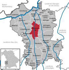
Kammeltal (Kammeltal)
- municipality of Germany
Kammeltal, located in Bavaria, Germany, is a beautiful and serene area that offers various hiking opportunities for enthusiasts of all levels. The landscape is characterized by rolling hills, lush forests, and picturesque meadows, providing a scenic backdrop for outdoor adventures.
Hiking Trails
-
Kammeltal Valley Trail: This is a popular route that meanders through the stunning Kammeltal Valley. The trail is well-marked and features a mix of terrain, including forested areas and open fields. It’s suitable for families and beginners, offering stunning views along the way.
-
Wanderwege (Hiking Paths): There are multiple marked paths throughout the region, catering to different skill levels. Some paths are flat and easy, while others may provide more of a challenge with inclines and rough terrain.
-
Circular Routes: Many hikers enjoy taking circular routes that allow them to explore different parts of the Kammeltal region. These routes often include stops at local points of interest, such as historical towns or natural landmarks.
Points of Interest
- Natural Landmarks: The area is home to a variety of wildlife and plant species. Birdwatching and nature photography can be particularly rewarding in the pristine environment.
- Local Culture: As you hike, you may pass through charming villages with traditional Bavarian architecture and local eateries where you can sample regional cuisine.
- Historical Sites: Some trails may lead to monuments or sites of historical significance, adding an educational element to your hike.
Best Time to Hike
The optimal time for hiking in Kammeltal is typically from spring through early autumn. During these seasons, the weather is mild, and nature is in full bloom. However, it’s always advisable to check weather conditions before heading out.
Preparation Tips
- Gear: Ensure you have appropriate footwear, a good backpack, water, and snacks. Depending on the length and difficulty of your hike, you might also want to pack additional layers.
- Maps & Guides: While trails are generally well-marked, carrying a detailed map or a hiking app can help you navigate and discover additional routes.
- Stay Informed: Check local guidelines or trail conditions, as some paths may have seasonal restrictions or maintenance updates.
By exploring the charming landscapes and paths of Kammeltal, you'll experience the natural beauty of Bavaria while enjoying a refreshing outdoor activity. Whether you're an experienced hiker or just looking for a lovely walk in nature, Kammeltal has something to offer everyone!
- Country:

- Postal Code: 89358
- Local Dialing Code: 08283; 08225; 08223; 08222
- Licence Plate Code: GZ
- Coordinates: 48° 23' 0" N, 10° 22' 0" E


- GPS tracks (wikiloc): [Link]
- AboveSeaLevel: 468 м m
- Area: 41.74 sq km
- Population: 3082
- Web site: https://www.kammeltal.de/
- Wikipedia en: wiki(en)
- Wikipedia: wiki(de)
- Wikidata storage: Wikidata: Q503467
- Wikipedia Commons Category: [Link]
- Freebase ID: [/m/02q3bmx]
- GeoNames ID: Alt: [3209453]
- VIAF ID: Alt: [144890896]
- OSM relation ID: [964148]
- GND ID: Alt: [4777886-6]
- archINFORM location ID: [14530]
- Historical Gazetteer (GOV) ID: [KAMTA1JN58EJ]
- Bavarikon ID: [ODB_A00000668]
- German municipality key: 09774145
Shares border with regions:


Ichenhausen
- municipality of Germany
Ichenhausen, a charming town located in Bavaria, Germany, offers a variety of scenic hiking opportunities that are suitable for both beginners and experienced hikers. The region is characterized by its beautiful landscapes, including rolling hills, lush forests, and picturesque farmland....
- Country:

- Postal Code: 89335
- Local Dialing Code: 08223
- Licence Plate Code: GZ
- Coordinates: 48° 22' 16" N, 10° 18' 25" E


- GPS tracks (wikiloc): [Link]
- AboveSeaLevel: 492 м m
- Area: 34.22 sq km
- Population: 7166
- Web site: [Link]


Kötz
- municipality of Germany
Kötz, located in the district of Günzburg in Bavaria, Germany, is a charming area that offers various opportunities for hiking and enjoying nature. Here are some key points to consider when planning a hiking trip in Kötz:...
- Country:

- Postal Code: 89359
- Local Dialing Code: 08221
- Licence Plate Code: GZ
- Coordinates: 48° 25' 0" N, 10° 17' 0" E


- GPS tracks (wikiloc): [Link]
- AboveSeaLevel: 475 м m
- Area: 20.55 sq km
- Population: 2960
- Web site: [Link]

