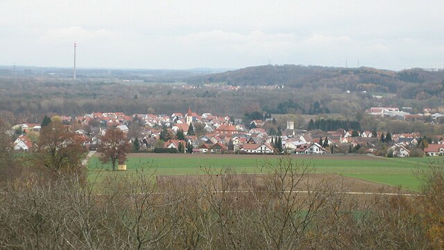
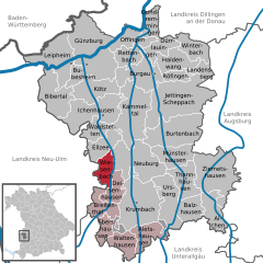
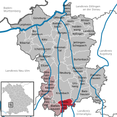
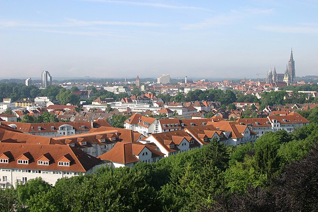
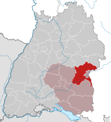
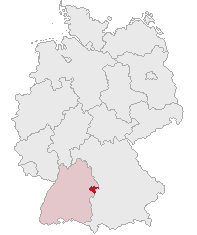
Günzburg (Landkreis Günzburg)

- district in Bavaria, Germany
 Hiking in Günzburg
Günzburg district, located in Bavaria, Germany, offers various hiking opportunities that showcase the beautiful landscapes of southern Germany. Here are some highlights about hiking in the area:
-
Scenic Trails: The region is characterized by rolling hills, lush forests, and charming villages, making it ideal for hiking. Trails often wind through peaceful countryside, featuring fields, rivers, and woodlands.
-
Danube River: The nearby Danube River provides various trails that follow the riverbanks, allowing hikers to experience stunning views and unique ecosystems. You can enjoy walking along well-marked paths that are suitable for all experience levels.
-
Legoland Deutschland Resort: For families, the Legoland area offers gentle hiking and walking paths where you can enjoy the theme park's surroundings. The family-friendly trails provide a pleasant hiking experience for those with children.
-
Historical Paths: Explore historical hiking trails in the area, which may take you through picturesque villages like Günzburg itself. Many trails have connections to local history and culture, allowing hikers to enjoy both nature and heritage.
-
Local Nature Reserves: The district is home to nature reserves and parks which provide opportunities for hiking in unspoiled natural environments. Places like the "Naturpark Augsburg – Westliche Wälder" nearby offer well-maintained hiking paths.
-
Hiking Tips:
- Always check trail conditions before setting out, as some paths can be influenced by weather.
- Bring essential gear such as water, good footwear, and a map or GPS.
- Try to hike with a buddy for safety and to enhance the experience.
-
Seasonal Considerations: Each season offers a different perspective of the landscape. Spring and summer provide blooming flowers and vibrant greenery, while autumn showcases colorful foliage. Winter hiking can also be enjoyable, particularly if you are equipped for colder conditions.
-
Local Events: Keep an eye out for local hiking events or guided tours that may be organized, giving you the chance to explore the region with knowledgeable guides.
Overall, hiking in Günzburg district can be an enjoyable experience for nature lovers, families, and anyone looking to explore the natural beauty of Bavaria. Whether you prefer leisurely walks or more challenging hikes, there are options suitable for everyone.
- Country:

- Capital: Günzburg
- Licence Plate Code: KRU; GZ
- Coordinates: 48° 19' 48" N, 10° 19' 48" E


- GPS tracks (wikiloc): [Link]
- AboveSeaLevel: 537 м m
- Area: 763.00 sq km
- Population: 107120
- Web site: http://www.landkreis-guenzburg.de/
- Wikipedia en: wiki(en)
- Wikipedia: wiki(de)
- Wikidata storage: Wikidata: Q10412
- Wikipedia Commons Category: [Link]
- Freebase ID: [/m/01qwc7]
- GeoNames ID: Alt: [3220874]
- VIAF ID: Alt: [314808053]
- OSM relation ID: [62664]
- GND ID: Alt: [4022459-4]
- archINFORM location ID: [3377]
- Library of Congress authority ID: Alt: [n81053328]
- TGN ID: [7077089]
- Bavarikon ID: [ODB_A00000650]
- NUTS code: [DE278]
- BabelNet ID: [02294313n]
- German district key: 09774
Includes regions:
Ebershauser-Nattenhauser Wald
- unincorporated area in Germany
Hiking in Ebershauser-Nattenhauser Wald
The Gemeindefreies Gebiet Ebershauser-Nattenhauser Wald is a beautiful area located in Germany, known for its serene forest landscapes and abundant natural beauty. Here are some insights into hiking in this region:...
- Country:
- Coordinates: 48° 12' 30" N, 10° 20' 20" E
- GPS tracks (wikiloc): [Link]
Winzerwald
- unincorporated area in Germany
Hiking in Winzerwald
Gemeindefreies Gebiet Winzerwald is a beautiful area located in Germany, particularly known for its diverse hiking opportunities. This region is characterized by dense forests, rolling hills, and scenic views that make it a wonderful destination for outdoor enthusiasts....
- Country:
- Coordinates: 48° 13' 0" N, 10° 26' 0" E
- GPS tracks (wikiloc): [Link]


Ellzee
- municipality of Germany
Hiking in Ellzee
Ellzee is a small municipality in Bavaria, Germany, known for its beautiful countryside and picturesque landscapes. While it may not be as famous for hiking as some larger natural parks or mountain regions, it still offers opportunities for outdoor enthusiasts to explore the local trails and enjoy the natural beauty of the area....
- Country:
- Postal Code: 89352
- Local Dialing Code: 08283
- Licence Plate Code: GZ
- Coordinates: 48° 20' 0" N, 10° 19' 0" E
- GPS tracks (wikiloc): [Link]
- AboveSeaLevel: 485 м m
- Area: 14.77 sq km
- Population: 1001
- Web site: [Link]


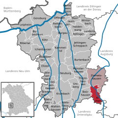
Ziemetshausen
- municipality of Germany
Hiking in Ziemetshausen
Ziemetshausen, located in the Augsburg District of Bavaria, Germany, offers a charming backdrop for hiking enthusiasts. The region is characterized by its picturesque landscapes, with rolling hills, lush forests, and scenic countryside. Here are some key points about hiking in Ziemetshausen:...
- Country:
- Postal Code: 86473
- Local Dialing Code: 08284
- Licence Plate Code: GZ
- Coordinates: 48° 18' 0" N, 10° 32' 0" E
- GPS tracks (wikiloc): [Link]
- AboveSeaLevel: 484 м m
- Area: 42.99 sq km
- Population: 2952
- Web site: [Link]


Thannhausen
- human settlement in Germany
Hiking in Thannhausen
Thannhausen, located in the Swabian region of Germany, offers a variety of hiking opportunities that are suitable for different skill levels. The area is characterized by scenic landscapes, rolling hills, and lush forests, making it a great destination for nature lovers....
- Country:
- Postal Code: 86470
- Local Dialing Code: 08281
- Licence Plate Code: GZ
- Coordinates: 48° 16' 0" N, 10° 28' 0" E
- GPS tracks (wikiloc): [Link]
- AboveSeaLevel: 499 м m
- Area: 20.03 sq km
- Population: 4825
- Web site: [Link]

Dürrlauingen
- municipality of Germany
Hiking in Dürrlauingen
Dürrlauingen is a small village located in Germany, surrounded by beautiful natural scenery that is ideal for hiking enthusiasts. Though it may not be as widely known as some other hiking locations, it offers a range of trails suitable for different skill levels....
- Country:
- Postal Code: 89350
- Local Dialing Code: 08222
- Licence Plate Code: GZ
- Coordinates: 48° 28' 0" N, 10° 26' 0" E
- GPS tracks (wikiloc): [Link]
- AboveSeaLevel: 503 м m
- Area: 12.34 sq km
- Population: 1862
- Web site: [Link]


Bibertal
- municipality of Germany
Hiking in Bibertal
Bibertal is a beautiful region in Bavaria, Germany, known for its picturesque landscapes and variety of hiking trails. Here are some key points to consider when planning a hiking trip in this area:...
- Country:
- Postal Code: 89346
- Local Dialing Code: 08226
- Licence Plate Code: GZ
- Coordinates: 48° 24' 0" N, 10° 12' 0" E
- GPS tracks (wikiloc): [Link]
- AboveSeaLevel: 495 м m
- Area: 27.31 sq km
- Population: 4021
- Web site: [Link]

Aichen
- municipality of Germany
Hiking in Aichen
Aichen, located in Germany, is surrounded by beautiful landscapes and offers various hiking opportunities that cater to different skill levels. While it might not be as widely known as other hiking destinations in the country, the region boasts picturesque trails that showcase its natural beauty....
- Country:
- Postal Code: 86479
- Local Dialing Code: 08284
- Licence Plate Code: GZ
- Coordinates: 48° 13' 36" N, 10° 32' 32" E
- GPS tracks (wikiloc): [Link]
- AboveSeaLevel: 510 м m
- Area: 17.60 sq km
- Population: 1063
- Web site: [Link]


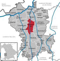
Günzburg
- town in Bavaria, Germany
Hiking in Günzburg
Günzburg, located in Bavaria, Germany, is known for its scenic landscapes and outdoor recreational opportunities, making it a great destination for hiking enthusiasts. Here are some highlights and tips for hiking in and around Günzburg:...
- Country:
- Postal Code: 89312
- Local Dialing Code: 08221
- Licence Plate Code: GZ
- Coordinates: 48° 27' 9" N, 10° 16' 16" E
- GPS tracks (wikiloc): [Link]
- AboveSeaLevel: 470 м m
- Area: 55.40 sq km
- Population: 18217
- Web site: [Link]


Ichenhausen
- municipality of Germany
Hiking in Ichenhausen
Ichenhausen, a charming town located in Bavaria, Germany, offers a variety of scenic hiking opportunities that are suitable for both beginners and experienced hikers. The region is characterized by its beautiful landscapes, including rolling hills, lush forests, and picturesque farmland....
- Country:
- Postal Code: 89335
- Local Dialing Code: 08223
- Licence Plate Code: GZ
- Coordinates: 48° 22' 16" N, 10° 18' 25" E
- GPS tracks (wikiloc): [Link]
- AboveSeaLevel: 492 м m
- Area: 34.22 sq km
- Population: 7166
- Web site: [Link]

Kammeltal
- municipality of Germany
Hiking in Kammeltal
Kammeltal, located in Bavaria, Germany, is a beautiful and serene area that offers various hiking opportunities for enthusiasts of all levels. The landscape is characterized by rolling hills, lush forests, and picturesque meadows, providing a scenic backdrop for outdoor adventures....
- Country:
- Postal Code: 89358
- Local Dialing Code: 08283; 08225; 08223; 08222
- Licence Plate Code: GZ
- Coordinates: 48° 23' 0" N, 10° 22' 0" E
- GPS tracks (wikiloc): [Link]
- AboveSeaLevel: 468 м m
- Area: 41.74 sq km
- Population: 3082
- Web site: [Link]

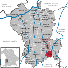
Balzhausen
- municipality of Germany
Hiking in Balzhausen
Balzhausen is a small village located in the Swabian region of Bavaria, Germany. While it may not be as well-known as some larger hiking destinations, the area offers beautiful landscapes and a chance to enjoy the serene countryside. Here are some key points to consider if you're planning a hike in and around Balzhausen:...
- Country:
- Postal Code: 86483
- Local Dialing Code: 08281
- Licence Plate Code: GZ
- Coordinates: 48° 14' 0" N, 10° 30' 0" E
- GPS tracks (wikiloc): [Link]
- AboveSeaLevel: 516 м m
- Area: 14.65 sq km
- Population: 971
- Web site: [Link]


Deisenhausen
- municipality of Germany
Hiking in Deisenhausen
Deisenhausen is a small village located in Bavaria, Germany, and while it may not be as well-known for hiking as some of the larger cities or national parks in the country, it offers opportunities for outdoor enthusiasts....
- Country:
- Postal Code: 86489
- Local Dialing Code: 08282
- Licence Plate Code: GZ
- Coordinates: 48° 15' 0" N, 10° 20' 0" E
- GPS tracks (wikiloc): [Link]
- AboveSeaLevel: 507 м m
- Area: 11.67 sq km
- Population: 1321
- Web site: [Link]


Leipheim
- municipality of Germany
Hiking in Leipheim
Leipheim, located in Bavaria, Germany, offers some pleasant hiking opportunities in and around the area. While it may not be as renowned as other hiking destinations in the Alps or more mountainous regions, it serves as a great base for exploring the surrounding landscapes....
- Country:
- Postal Code: 89340
- Local Dialing Code: 08221
- Licence Plate Code: GZ
- Coordinates: 48° 27' 0" N, 10° 13' 22" E
- GPS tracks (wikiloc): [Link]
- AboveSeaLevel: 471 м m
- Area: 32.15 sq km
- Population: 5132
- Web site: [Link]

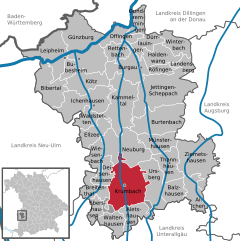
Krumbach
- town in Germany
Hiking in Krumbach
Krumbach, located in Bavaria, Germany, is a charming destination for hiking enthusiasts. Nestled in the picturesque Allgäu region, it offers a variety of trails that cater to hikers of all skill levels, from leisurely walks to more challenging hikes....
- Country:
- Postal Code: 86381
- Local Dialing Code: 08282
- Coordinates: 48° 14' 35" N, 10° 21' 48" E
- GPS tracks (wikiloc): [Link]
- AboveSeaLevel: 512 м m
- Area: 44.75 sq km
- Population: 11757
- Web site: [Link]

Haldenwang
- municipality of Germany in the district of Günzburg
Hiking in Haldenwang
Haldenwang is a charming village located in Bavaria, Germany, known for its picturesque landscapes and outdoor recreational opportunities, including hiking. Here are some highlights and tips for hiking in the Haldenwang area:...
- Country:
- Postal Code: 89356
- Local Dialing Code: 08222
- Licence Plate Code: GZ
- Coordinates: 48° 26' 0" N, 10° 26' 0" E
- GPS tracks (wikiloc): [Link]
- AboveSeaLevel: 480 м m
- Area: 17.98 sq km
- Population: 1615
- Web site: [Link]


Münsterhausen
- municipality of Germany
Hiking in Münsterhausen
Münsterhausen, a small village in Bavaria, Germany, offers a wonderful experience for hikers looking to explore the picturesque landscapes of the region. The surrounding area is characterized by lush green fields, rolling hills, and scenic forest trails, making it perfect for outdoor activities such as hiking....
- Country:
- Postal Code: 86505
- Local Dialing Code: 08281
- Licence Plate Code: GZ
- Coordinates: 48° 18' 42" N, 10° 27' 9" E
- GPS tracks (wikiloc): [Link]
- AboveSeaLevel: 492 м m
- Area: 18.47 sq km
- Population: 1709
- Web site: [Link]
Bubesheim
- municipality of Germany
Hiking in Bubesheim
Bubesheim, a charming village located in Bavaria, Germany, is surrounded by scenic landscapes that can offer a variety of hiking opportunities. While it may not be as well-known as some larger hiking destinations in the region, it can serve as a great base for exploring the beautiful countryside and nearby nature parks....
- Country:
- Postal Code: 89347
- Local Dialing Code: 08221
- Licence Plate Code: GZ
- Coordinates: 48° 26' 0" N, 10° 15' 0" E
- GPS tracks (wikiloc): [Link]
- AboveSeaLevel: 466 м m
- Area: 7.76 sq km
- Population: 1149
- Web site: [Link]


Burgau
- municipality of Germany
Hiking in Burgau
Burgau, a charming coastal town in the Algarve region of Portugal, offers beautiful landscapes perfect for hiking enthusiasts. The town is nestled along the stunning cliffs of the Atlantic and is surrounded by picturesque scenery, including beaches, rural areas, and natural parks. Here are some highlights for hiking in and around Burgau:...
- Country:
- Postal Code: 89331
- Local Dialing Code: 08222
- Licence Plate Code: GZ
- Coordinates: 48° 25' 54" N, 10° 24' 36" E
- GPS tracks (wikiloc): [Link]
- AboveSeaLevel: 454 м m
- Area: 25.92 sq km
- Population: 8111
- Web site: [Link]


Jettingen-Scheppach
- municipality of Germany
Hiking in Jettingen-Scheppach
Jettingen-Scheppach is a charming area located in Bavaria, Germany, making it an appealing destination for hikers and nature enthusiasts. While it may not be a famous hiking destination, it offers various trails that showcase the beautiful Bavarian countryside....
- Country:
- Postal Code: 89343
- Local Dialing Code: 08225
- Licence Plate Code: GZ
- Coordinates: 48° 23' 0" N, 10° 26' 0" E
- GPS tracks (wikiloc): [Link]
- AboveSeaLevel: 470 м m
- Area: 54.07 sq km
- Population: 6953
- Web site: [Link]

Offingen
- municipality in Bavaria, Germany
Hiking in Offingen
Offingen is a small town located in Bavaria, Germany, known for its picturesque landscapes and charming surroundings that make it suitable for hiking enthusiasts. Here are some key points about hiking in and around Offingen:...
- Country:
- Postal Code: 89362
- Local Dialing Code: 08224
- Licence Plate Code: GZ
- Coordinates: 48° 28' 0" N, 10° 22' 0" E
- GPS tracks (wikiloc): [Link]
- AboveSeaLevel: 440 м m
- Area: 14.93 sq km
- Population: 3330
- Web site: [Link]


Gundremmingen
- municipality of Germany
Hiking in Gundremmingen
Gundremmingen is a small town in Bavaria, Germany, known for its picturesque landscapes along the borders of the Danube River. While it's not a major hiking destination, it offers several routes that allow you to enjoy the beauty of the Bavarian countryside....
- Country:
- Postal Code: 89355
- Local Dialing Code: 08224
- Licence Plate Code: GZ
- Coordinates: 48° 30' 0" N, 10° 24' 0" E
- GPS tracks (wikiloc): [Link]
- AboveSeaLevel: 437 м m
- Area: 10.84 sq km
- Population: 1124
- Web site: [Link]


Ursberg
- municipality of Germany
Hiking in Ursberg
Ursberg, located in the Landkreis Günzburg in Bavaria, Germany, offers a beautiful setting for hiking enthusiasts. Nestled in the scenic landscapes of Swabia, the area is characterized by its rolling hills, lush forests, and charming villages....
- Country:
- Postal Code: 86513
- Local Dialing Code: 08281
- Licence Plate Code: GZ
- Coordinates: 48° 16' 0" N, 10° 27' 0" E
- GPS tracks (wikiloc): [Link]
- AboveSeaLevel: 508 м m
- Area: 25.42 sq km
- Population: 3587
- Web site: [Link]


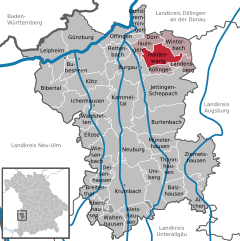
Winterbach
- municipality of Germany
Hiking in Winterbach
Winterbach, located in Bavaria, Germany, offers a beautiful setting for hiking enthusiasts. Nestled in the Swabian Jura, this area features a range of trails that cater to different experience levels, from easy strolls to more challenging hikes....
- Country:
- Postal Code: 89368
- Local Dialing Code: 08283
- Licence Plate Code: GZ
- Coordinates: 48° 28' 0" N, 10° 29' 0" E
- GPS tracks (wikiloc): [Link]
- AboveSeaLevel: 462 м m
- Area: 14.82 sq km
- Population: 826
- Web site: [Link]


Röfingen
- municipality of Germany
Hiking in Röfingen
Röfingen is a small village in Bavaria, Germany, located near the well-known city of Augsburg. While it may not be a widely recognized hiking destination, it does offer access to some beautiful landscapes and rural trails typical of the Bavarian countryside. Here are a few tips and highlights for hiking in and around Röfingen:...
- Country:
- Postal Code: 89365
- Local Dialing Code: 08222
- Licence Plate Code: GZ
- Coordinates: 48° 26' 0" N, 10° 26' 0" E
- GPS tracks (wikiloc): [Link]
- AboveSeaLevel: 474 м m
- Area: 6.62 sq km
- Population: 1099
- Web site: [Link]

Landensberg
- municipality in Günzburg, Bavaria, Germany
Hiking in Landensberg
Landensberg is a beautiful area in the heart of nature, offering a variety of hiking opportunities for outdoor enthusiasts. Here are some highlights to consider when planning a hike in Landensberg:...
- Country:
- Postal Code: 89361
- Local Dialing Code: 08222
- Licence Plate Code: GZ
- Coordinates: 48° 26' 0" N, 10° 32' 0" E
- GPS tracks (wikiloc): [Link]
- AboveSeaLevel: 508 м m
- Area: 7.95 sq km
- Population: 616
- Web site: [Link]


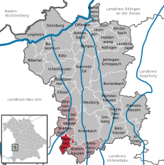
Waltenhausen
- municipality of Germany
Hiking in Waltenhausen
Waltenhausen is a picturesque village located in Bavaria, Germany, which offers beautiful landscapes for hiking enthusiasts. Here are some key aspects to consider for hiking in and around Waltenhausen:...
- Country:
- Postal Code: 86480
- Local Dialing Code: 08263
- Licence Plate Code: GZ
- Coordinates: 48° 11' 24" N, 10° 21' 53" E
- GPS tracks (wikiloc): [Link]
- AboveSeaLevel: 547 м m
- Area: 13.43 sq km
- Population: 607

Wiesenbach
- municipality in Bavaria, Germany
Hiking in Wiesenbach
Wiesenbach, located in Bavaria, Germany, is a charming village surrounded by scenic landscapes, making it an excellent destination for hiking enthusiasts. The region features lush forests, rolling hills, and beautiful views of the surrounding countryside. Here’s what you can expect when hiking in Wiesenbach:...
- Country:
- Postal Code: 86519
- Local Dialing Code: 08283
- Licence Plate Code: GZ
- Coordinates: 48° 16' 0" N, 10° 20' 0" E
- GPS tracks (wikiloc): [Link]
- AboveSeaLevel: 500 м m
- Area: 11.47 sq km
- Population: 845
- Web site: [Link]

Aletshausen
- municipality of Germany
Hiking in Aletshausen
Aletshausen, a small village in Bavaria, Germany, is surrounded by beautiful natural landscapes that make it a great destination for hiking enthusiasts. While it may not be as well-known as some larger hiking areas in Germany, it offers a variety of trails suitable for different skill levels. Here are some details about hiking in and around Aletshausen:...
- Country:
- Postal Code: 86480
- Local Dialing Code: 08282
- Licence Plate Code: GZ
- Coordinates: 48° 12' 0" N, 10° 23' 0" E
- GPS tracks (wikiloc): [Link]
- AboveSeaLevel: 527 м m
- Area: 17.65 sq km
- Population: 1036
- Web site: [Link]


Waldstetten
- municipality of Germany
Hiking in Waldstetten
Waldstetten, located in Bavaria, Germany, is a charming village that offers beautiful landscapes and numerous hiking opportunities. Surrounded by lush forests, rolling hills, and scenic views, it is an excellent destination for both novice and experienced hikers....
- Country:
- Postal Code: 89367
- Local Dialing Code: 08223
- Licence Plate Code: GZ
- Coordinates: 48° 21' 0" N, 10° 18' 0" E
- GPS tracks (wikiloc): [Link]
- AboveSeaLevel: 497 м m
- Area: 11.13 sq km
- Population: 1007
- Web site: [Link]


Rettenbach
- municipality of Germany
Hiking in Rettenbach
Rettenbach is a small village located in the Swabian region of Germany, known for its picturesque landscapes and access to various outdoor activities, including hiking. The region features rolling hills, forests, and scenic views, making it an attractive destination for nature lovers and outdoor enthusiasts....
- Country:
- Postal Code: 89364
- Local Dialing Code: 08224
- Licence Plate Code: GZ
- Coordinates: 48° 28' 0" N, 10° 21' 0" E
- GPS tracks (wikiloc): [Link]
- AboveSeaLevel: 490 м m
- Area: 12.75 sq km
- Population: 1275
- Web site: [Link]

Ebershausen
- municipality of Germany
Hiking in Ebershausen
Ebershausen, located in Bavaria, Germany, is surrounded by beautiful landscapes that make it a great destination for hiking enthusiasts. The area features numerous trails that vary in difficulty, making it suitable for both beginners and experienced hikers....
- Country:
- Postal Code: 86491
- Local Dialing Code: 08282
- Licence Plate Code: GZ
- Coordinates: 48° 12' 0" N, 10° 19' 0" E
- GPS tracks (wikiloc): [Link]
- AboveSeaLevel: 541 м m
- Area: 622 sq km
- Population: 582
- Web site: [Link]


Burtenbach
- municipality of Germany
Hiking in Burtenbach
Burtenbach is a small town located in Bavaria, Germany, known for its picturesque landscapes and proximity to natural attractions. Hiking in and around Burtenbach offers a variety of routes suitable for different skill levels, allowing hikers to enjoy the scenic beauty of the Bavarian countryside....
- Country:
- Postal Code: 89349
- Local Dialing Code: 08285
- Licence Plate Code: GZ
- Coordinates: 48° 21' 0" N, 10° 27' 0" E
- GPS tracks (wikiloc): [Link]
- AboveSeaLevel: 485 м m
- Area: 37.64 sq km
- Population: 2990
- Web site: [Link]


Breitenthal
- municipality of Germany
Hiking in Breitenthal
Breitenthal, located in the scenic region of southern Germany, offers a variety of hiking opportunities for outdoor enthusiasts. While details about specific trails in Breitenthal may not be as well-known as in larger national parks, the area is surrounded by beautiful landscapes, dense forests, and rolling hills that can make for an enjoyable hiking experience....
- Country:
- Postal Code: 86488
- Local Dialing Code: 08282
- Licence Plate Code: GZ
- Coordinates: 48° 14' 0" N, 10° 18' 0" E
- GPS tracks (wikiloc): [Link]
- AboveSeaLevel: 528 м m
- Area: 13.27 sq km
- Population: 954
- Web site: [Link]


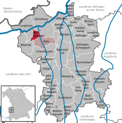
Kötz
- municipality of Germany
Hiking in Kötz
Kötz, located in the district of Günzburg in Bavaria, Germany, is a charming area that offers various opportunities for hiking and enjoying nature. Here are some key points to consider when planning a hiking trip in Kötz:...
- Country:
- Postal Code: 89359
- Local Dialing Code: 08221
- Licence Plate Code: GZ
- Coordinates: 48° 25' 0" N, 10° 17' 0" E
- GPS tracks (wikiloc): [Link]
- AboveSeaLevel: 475 м m
- Area: 20.55 sq km
- Population: 2960
- Web site: [Link]


Neuburg an der Kammel
- municipality of Germany
Hiking in Neuburg an der Kammel
Neuburg an der Kammel, situated in the Swabian region of Bavaria, Germany, offers a variety of hiking opportunities for outdoor enthusiasts. The region is characterized by its picturesque landscapes, lush forests, and rolling hills, making it an ideal spot for both casual walkers and serious hikers....
- Country:
- Postal Code: 86476
- Local Dialing Code: 08283
- Licence Plate Code: GZ
- Coordinates: 48° 18' 14" N, 10° 21' 36" E
- GPS tracks (wikiloc): [Link]
- AboveSeaLevel: 506 м m
- Area: 37.90 sq km
- Population: 2757
- Web site: [Link]
Shares border with regions:

Unterallgäu
- district in Bavaria, Germany
Hiking in Unterallgäu
Unterallgäu is a beautiful region in Bavaria, Germany, known for its picturesque landscapes, charming villages, and extensive hiking trails. Located in the Allgäu, it's characterized by rolling hills, lush meadows, and stunning views of the Alpine foothills. Here are some highlights if you're considering hiking in Unterallgäu:...
- Country:
- Capital: Mindelheim
- Licence Plate Code: MN
- Coordinates: 48° 0' 0" N, 10° 30' 0" E
- GPS tracks (wikiloc): [Link]
- Area: 1230.24 sq km
- Population: 115770
- Web site: [Link]


Neu-Ulm
- district in Bavaria, Germany
Hiking in Neu-Ulm
Neu-Ulm, located in Bavaria, Germany, offers several options for hiking enthusiasts. The region is known for its picturesque landscapes, combining rivers, hills, and forests. Here are some key points about hiking in Neu-Ulm:...
- Country:
- Capital: Neu-Ulm
- Licence Plate Code: NU; ILL
- Coordinates: 48° 20' 0" N, 10° 10' 0" E
- GPS tracks (wikiloc): [Link]
- AboveSeaLevel: 474 м m
- Area: 515.00 sq km
- Population: 140666
- Web site: [Link]
Augsburg
- district in Bavaria, Germany
Hiking in Augsburg
Augsburg is a city in Bavaria, Germany, known for its rich history and beautiful surroundings, making it a great base for hiking enthusiasts. While the city itself offers various parks and local trails, the surrounding district provides a variety of hiking options for different skill levels. Here are some highlights:...
- Country:
- Capital: Augsburg
- Licence Plate Code: A
- Coordinates: 48° 25' 12" N, 10° 49' 48" E
- GPS tracks (wikiloc): [Link]
- AboveSeaLevel: 521 м m
- Area: 1071.00 sq km
- Population: 191469
- Web site: [Link]

Dillingen
- district in Bavaria, Germany
Hiking in Dillingen
Dillingen, located in Bavaria, Germany, offers a variety of hiking opportunities amidst beautiful landscapes. The district is characterized by rolling hills, lush forests, and scenic views, making it an excellent destination for both casual walkers and serious hikers....
- Country:
- Capital: Dillingen an der Donau
- Licence Plate Code: WER; DLG
- Coordinates: 48° 34' 48" N, 10° 25' 12" E
- GPS tracks (wikiloc): [Link]
- AboveSeaLevel: 425 м m
- Area: 792.00 sq km
- Population: 80209
- Web site: [Link]
Alb-Donau-Kreis
- district in Baden-Württemberg, Germany
Hiking in Alb-Donau-Kreis
The Alb-Donau-Kreis is a beautiful district located in Baden-Württemberg, Germany, known for its diverse landscapes, rich nature, and historical sites. Hiking in this area offers a range of trails suitable for all levels of hikers, from beginners to more experienced trekkers. Here are some highlights and tips for hiking in Alb-Donau-Kreis:...
- Country:
- Capital: Ulm
- Licence Plate Code: UL
- Coordinates: 48° 24' 0" N, 9° 51' 0" E
- GPS tracks (wikiloc): [Link]
- AboveSeaLevel: 670 м m
- Area: 1358.67 sq km
- Population: 192104
- Web site: [Link]

Heidenheim
- district in Baden-Württemberg, Germany
Hiking in Heidenheim
Heidenheim, located in Baden-Württemberg, Germany, is a region that offers a variety of hiking opportunities amidst beautiful landscapes, historical sites, and natural attractions. Here are some aspects to consider when hiking in Heidenheim and its surroundings:...
- Country:
- Licence Plate Code: HDH
- Coordinates: 48° 38' 24" N, 10° 7' 12" E
- GPS tracks (wikiloc): [Link]
- AboveSeaLevel: 599 м m
- Area: 627.13 sq km
- Population: 130527
- Web site: [Link]