
Swabia (Schwaben)


- administrative regions of Bavaria, Germany
 Hiking in Swabia
Swabia, a picturesque region in Bavaria, Germany, offers a variety of hiking opportunities ranging from gentle walks to challenging trails. Known for its diverse landscapes, Swabia features lush forests, rolling hills, scenic lakes, and impressive mountain ranges, making it a fantastic destination for outdoor enthusiasts.
Key Highlights of Hiking in Swabia:
-
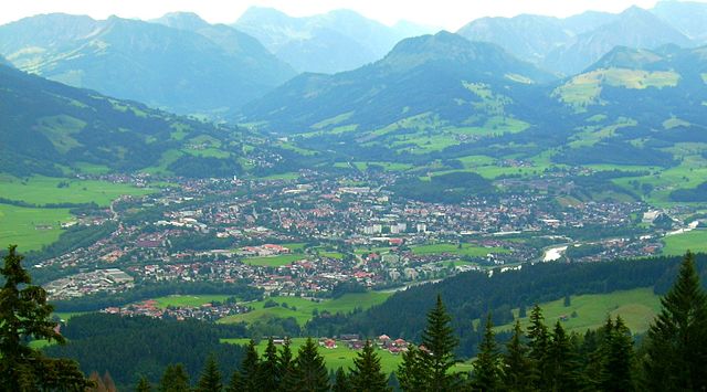
Beautiful Landscapes: Hikers can enjoy stunning views of the Alps, especially in the Allgäu region, which is famous for its fairy-tale landscapes, meadows, and charming villages. The Swabian Jura (Schwäbische Alb) also boasts dramatic cliffs and unique rock formations.
-
Well-Marked Trails: Swabia offers a network of well-marked trails catering to all skill levels. The routes range from short, family-friendly walks to long-distance hikes, such as sections of the European long-distance paths.
-
Popular Hiking Areas:
- Allgäu: This area features a mix of rolling hills, pastures, and mountain scenery. The famous "Romantic Road" offers numerous hiking options, while attractions like Neuschwanstein Castle provide stunning backdrops.
- Swabian Jura: Known for its limestone cliffs and unique karst landscapes, the Swabian Jura offers challenges for experienced hikers and beautiful views from its peaks, such as the Lichtenstein Castle.
- Lake Constance: The area around Lake Constance offers picturesque lakeside trails and hiking paths through vineyards. The Bodensee-Rundweg is a popular route for scenic strolls.
-
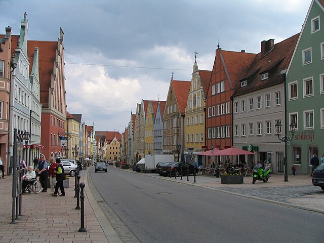
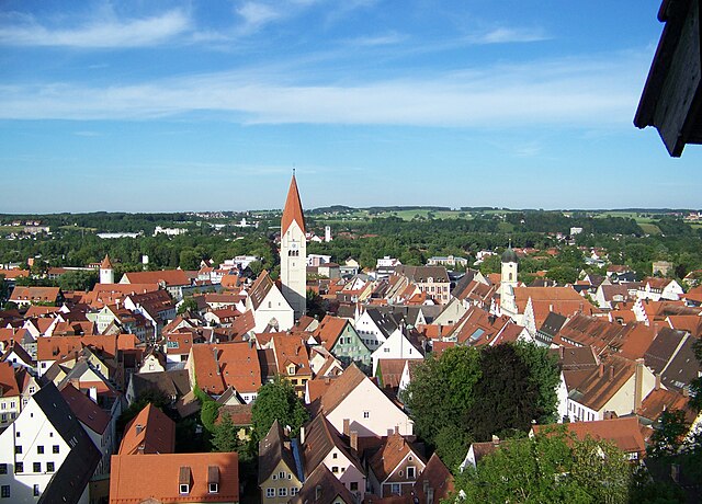
Cultural Experiences: Along your hikes, you can experience Swabian culture, including traditional cuisine and historical sites. Many trails lead through quaint towns and villages where you can sample local dishes like Maultaschen (Swabian dumplings) and Kässpätzle (cheese noodles).
-
Wildlife and Nature: Swabia is home to diverse flora and fauna, and many hiking paths pass through nature reserves. Birdwatching is also popular in the region, particularly around the lakes and wetlands.
-
Accessibility: Most hiking trails are easily accessible from major towns and cities, including Augsburg, Ulm, and Füssen, making it convenient for both day hikes and longer excursions.
-
Seasonal Hiking: Spring and summer are popular for hiking due to mild weather, while the autumn months provide beautiful fall foliage. Winter hiking is also possible in certain areas, particularly in the Alpine regions, and snowshoeing can be a unique experience.
Tips for Hiking in Swabia:
- Stay Hydrated and Prepared: Always carry enough water and snacks and wear appropriate hiking footwear.
- Check Trail Conditions: Local weather conditions can impact trail accessibility, so it’s wise to check before setting out.
- Use a Map or GPS: Familiarize yourself with the trail maps and consider using GPS for navigation.
- Respect Nature: Adhere to the Leave No Trace principles to preserve the beauty of the natural environment.
Swabia's blend of natural beauty, rich history, and delicious food makes it a wonderful destination for hiking enthusiasts! Whether you are a beginner or an experienced hiker, there are plenty of trails for you to explore.
- Country:

- Capital: Augsburg
- Coordinates: 48° 30' 0" N, 10° 30' 0" E


- GPS tracks (wikiloc): [Link]
- AboveSeaLevel: 560 м m
- Area: 9992.03 sq km
- Population: 1857991
- Web site: https://www.bezirk-schwaben.de/
- Wikipedia en: wiki(en)
- Wikipedia: wiki(de)
- Wikidata storage: Wikidata: Q10557
- Wikipedia Commons Category: [Link]
- Freebase ID: [/m/0dz5n]
- GeoNames ID: Alt: [2835521]
- VIAF ID: Alt: [150182663]
- OSM relation ID: [17657]
- GND ID: Alt: [2036719-3]
- Library of Congress authority ID: Alt: [n86119713]
- EMLO location ID: [b40375eb-6e85-4c1f-8669-c069f034b8fc]
- ISNI: Alt: [0000 0004 0630 5171]
- NUTS code: [DE27]
- Ringgold ID: [61001]
- German regional key: 097
Includes regions:
Lindau
- rural district in Bavaria, Germany
Hiking in Lindau
Lindau, located in southern Germany on the shores of Lake Constance (Bodensee), offers a beautiful setting for hiking enthusiasts. The district encompasses a variety of natural landscapes, including picturesque lake views, rolling hills, lush forests, and charming villages. Here are some highlights for hiking in Lindau:...
- Country:
- Capital: Lindau
- Licence Plate Code: LI
- Coordinates: 47° 36' 0" N, 9° 51' 36" E
- GPS tracks (wikiloc): [Link]
- AboveSeaLevel: 496 м m
- Area: 323.00 sq km
- Population: 69522
- Web site: [Link]
Oberallgäu
- district in Bavaria, Germany
Hiking in Oberallgäu
Oberallgäu, located in Bavaria, Germany, is a stunning region known for its breathtaking landscapes, rolling hills, and majestic Alps. It offers a wide range of hiking opportunities suitable for all levels of experience, from leisurely walks to challenging mountain ascents. Here are some highlights and tips for hiking in Oberallgäu:...
- Country:
- Capital: Sonthofen
- Licence Plate Code: OA
- Coordinates: 47° 34' 48" N, 10° 15' 0" E
- GPS tracks (wikiloc): [Link]
- AboveSeaLevel: 711 м m
- Area: 1528.00 sq km
- Population: 128665
- Web site: [Link]

Ostallgäu
- district in Bavaria, Germany
Hiking in Ostallgäu
Ostallgäu is a picturesque region in Bavaria, Germany, known for its stunning landscapes dominated by the Alps, rolling hills, and charming villages. It's an excellent destination for hiking, offering a variety of trails suitable for different skill levels, from beginner to advanced. Here are some key highlights of hiking in Ostallgäu:...
- Country:
- Capital: Marktoberdorf
- Licence Plate Code: OAL; MOD; FÜS
- Coordinates: 47° 45' 0" N, 10° 34' 48" E
- GPS tracks (wikiloc): [Link]
- AboveSeaLevel: 724 м m
- Area: 1395.00 sq km
- Population: 114547
- Web site: [Link]

Unterallgäu
- district in Bavaria, Germany
Hiking in Unterallgäu
Unterallgäu is a beautiful region in Bavaria, Germany, known for its picturesque landscapes, charming villages, and extensive hiking trails. Located in the Allgäu, it's characterized by rolling hills, lush meadows, and stunning views of the Alpine foothills. Here are some highlights if you're considering hiking in Unterallgäu:...
- Country:
- Capital: Mindelheim
- Licence Plate Code: MN
- Coordinates: 48° 0' 0" N, 10° 30' 0" E
- GPS tracks (wikiloc): [Link]
- Area: 1230.24 sq km
- Population: 115770
- Web site: [Link]


Neu-Ulm
- district in Bavaria, Germany
Hiking in Neu-Ulm
Neu-Ulm, located in Bavaria, Germany, offers several options for hiking enthusiasts. The region is known for its picturesque landscapes, combining rivers, hills, and forests. Here are some key points about hiking in Neu-Ulm:...
- Country:
- Capital: Neu-Ulm
- Licence Plate Code: NU; ILL
- Coordinates: 48° 20' 0" N, 10° 10' 0" E
- GPS tracks (wikiloc): [Link]
- AboveSeaLevel: 474 м m
- Area: 515.00 sq km
- Population: 140666
- Web site: [Link]

Günzburg
- district in Bavaria, Germany
Hiking in Günzburg
Günzburg district, located in Bavaria, Germany, offers various hiking opportunities that showcase the beautiful landscapes of southern Germany. Here are some highlights about hiking in the area:...
- Country:
- Capital: Günzburg
- Licence Plate Code: KRU; GZ
- Coordinates: 48° 19' 48" N, 10° 19' 48" E
- GPS tracks (wikiloc): [Link]
- AboveSeaLevel: 537 м m
- Area: 763.00 sq km
- Population: 107120
- Web site: [Link]
Augsburg
- district in Bavaria, Germany
Hiking in Augsburg
Augsburg is a city in Bavaria, Germany, known for its rich history and beautiful surroundings, making it a great base for hiking enthusiasts. While the city itself offers various parks and local trails, the surrounding district provides a variety of hiking options for different skill levels. Here are some highlights:...
- Country:
- Capital: Augsburg
- Licence Plate Code: A
- Coordinates: 48° 25' 12" N, 10° 49' 48" E
- GPS tracks (wikiloc): [Link]
- AboveSeaLevel: 521 м m
- Area: 1071.00 sq km
- Population: 191469
- Web site: [Link]
Aichach-Friedberg
- district in Bavaria, Germany
Hiking in Aichach-Friedberg
Aichach-Friedberg is a beautiful region located in Bavaria, Germany, known for its diverse landscapes, charming villages, and historical sites. Hiking in this area offers a variety of trails that cater to different skill levels, making it an excellent destination for both novice hikers and experienced outdoor enthusiasts....
- Country:
- Capital: Aichach
- Licence Plate Code: FDB; AIC
- Coordinates: 48° 25' 12" N, 11° 4' 48" E
- GPS tracks (wikiloc): [Link]
- AboveSeaLevel: 483 м m
- Area: 781.00 sq km
- Population: 101792
- Web site: [Link]

Dillingen
- district in Bavaria, Germany
Hiking in Dillingen
Dillingen, located in Bavaria, Germany, offers a variety of hiking opportunities amidst beautiful landscapes. The district is characterized by rolling hills, lush forests, and scenic views, making it an excellent destination for both casual walkers and serious hikers....
- Country:
- Capital: Dillingen an der Donau
- Licence Plate Code: WER; DLG
- Coordinates: 48° 34' 48" N, 10° 25' 12" E
- GPS tracks (wikiloc): [Link]
- AboveSeaLevel: 425 м m
- Area: 792.00 sq km
- Population: 80209
- Web site: [Link]
Donau-Ries
- district in Bavaria, Germany
Hiking in Donau-Ries
Donau-Ries is a beautiful region in Bavaria, Germany, known for its stunning landscapes, rich history, and cultural significance. Spanning both the Danube River and the Ries crater, this area offers diverse hiking opportunities for both beginners and more experienced trekkers....
- Country:
- Capital: Donauwörth
- Licence Plate Code: NÖ; DON
- Coordinates: 48° 49' 48" N, 10° 40' 12" E
- GPS tracks (wikiloc): [Link]
- AboveSeaLevel: 508 м m
- Area: 1275.00 sq km
- Population: 117483
- Web site: [Link]
Kaufbeuren
- city in Bavaria, Germany
Hiking in Kaufbeuren
Kaufbeuren, situated in Bavaria, Germany, is a charming town with a rich history and beautiful landscapes, making it a great base for hiking enthusiasts. Here are some key points about hiking in the Kaufbeuren area:...
- Country:
- Postal Code: 87600
- Local Dialing Code: 08341
- Licence Plate Code: KF
- Coordinates: 47° 52' 48" N, 10° 37' 21" E
- GPS tracks (wikiloc): [Link]
- AboveSeaLevel: 678 м m
- Area: 40 sq km
- Population: 41759
- Web site: [Link]

Memmingen
- town in Bavaria, Germany
Hiking in Memmingen
Memmingen, located in Bavaria, Germany, is surrounded by picturesque landscapes and offers various hiking opportunities. Here’s an overview of what you can expect when hiking in and around Memmingen:...
- Country:
- Postal Code: 87700
- Local Dialing Code: 08331
- Licence Plate Code: MM
- Coordinates: 47° 59' 16" N, 10° 10' 52" E
- GPS tracks (wikiloc): [Link]
- AboveSeaLevel: 601 м m
- Area: 70 sq km
- Population: 42841
- Web site: [Link]
Augsburg
- city in Bavaria, Germany
Hiking in Augsburg
Augsburg, located in Bavaria, Germany, is a charming city that offers various outdoor activities, including hiking. While the city itself is urban, it provides easy access to beautiful natural landscapes in the surrounding areas, making it a great base for hiking enthusiasts....
- Country:
- Postal Code: 86179; 86169; 86167; 86165; 86163; 86161; 86159; 86157; 86156; 86154; 86153; 86152; 86199; 86150
- Local Dialing Code: 0821
- Licence Plate Code: A
- Coordinates: 48° 22' 18" N, 10° 53' 54" E
- GPS tracks (wikiloc): [Link]
- AboveSeaLevel: 482 м m
- Area: 146.87 sq km
- Population: 289584
- Web site: [Link]

Kempten
- town in Bavaria, Germany
Hiking in Kempten
Kempten, located in the Allgäu region of Bavaria, Germany, offers a variety of hiking options that cater to different skill levels and preferences. The picturesque surroundings, featuring the beautiful Allgäu Alps, lush meadows, and pristine rivers, make it an appealing destination for outdoor enthusiasts....
- Country:
- Postal Code: 87437; 87439; 87435
- Local Dialing Code: 0831
- Licence Plate Code: KE
- Coordinates: 47° 44' 0" N, 10° 19' 0" E
- GPS tracks (wikiloc): [Link]
- AboveSeaLevel: 674 м m
- Area: 63.29 sq km
- Population: 65624
- Web site: [Link]
Shares border with regions:


Middle Franconia
- administrative region of Franconia in Bavaria, Germany
Hiking in Middle Franconia
Middle Franconia, located in Bavaria, Germany, is a picturesque region known for its diverse landscapes, charming villages, and rich cultural heritage. It offers a variety of hiking opportunities suitable for all levels of experience. Here are some highlights regarding hiking in this area:...
- Country:
- Capital: Ansbach
- Coordinates: 49° 18' 0" N, 10° 35' 0" E
- GPS tracks (wikiloc): [Link]
- AboveSeaLevel: 401 м m
- Area: 7245.70 sq km
- Population: 1750059
- Web site: [Link]


Upper Bavaria
- administrative regions of Bavaria, Germany
Hiking in Upper Bavaria
Upper Bavaria is a beautiful region in southern Germany, known for its stunning landscapes, charming villages, and a wealth of outdoor activities, particularly hiking. Here are some highlights and tips for hiking in Upper Bavaria:...
- Country:
- Capital: Munich
- Coordinates: 48° 8' 0" N, 11° 34' 0" E
- GPS tracks (wikiloc): [Link]
- AboveSeaLevel: 647 м m
- Area: 17529.63 sq km
- Population: 4588944
- Web site: [Link]