Kitzbühel District (Bezirk Kitzbühel)
- district of Austria
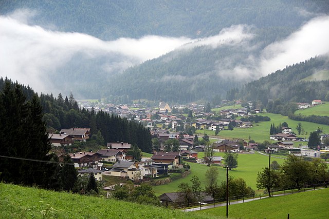
 Hiking in Kitzbühel District
Kitzbühel District, located in the Tyrol region of Austria, is a stunning destination for hiking enthusiasts. With its majestic mountains, lush valleys, and picturesque alpine villages, it offers a variety of hiking trails suitable for all levels, from beginners to experienced trekkers.
Key Highlights of Hiking in Kitzbühel District:
-
Scenic Trails: The area boasts an extensive network of hiking trails that lead through breathtaking landscapes. Trails often feature panoramic views of the surrounding mountains, including the famous Wilder Kaiser and Hohe Tauern ranges.
-
Kitzbüheler Horn: A prominent mountain in the district, with trails leading to its summit that provide stunning vistas. The Kitzbüheler Horn is also host to several alpine huts where hikers can enjoy local cuisine.
-
Hahnenkamm: Known primarily for its famous ski slopes, the Hahnenkamm offers beautiful summer hikes. Trails vary from easy to challenging, and the cable car can help you reach higher altitudes with ease.
-
St. Johann in Tirol: This nearby village has access to multiple hiking routes, perfect for families and those looking for more leisurely walks. Enjoy trails through lush meadows and tranquil forests.
-
Wildschönau Valley: Known for its gentle landscapes, this area is ideal for hikers looking for a less strenuous adventure. The trails are well-marked and offer opportunities to experience local wildlife and flora.
-
Alpine Flora and Fauna: Hikers can expect to see diverse plant species, including vibrant alpine flowers during the summer months, as well as a variety of wildlife, such as chamois, ibex, and different bird species.
-
Accommodation and Facilities: The Kitzbühel District has a wide range of accommodation options, from charming guesthouses to luxurious hotels. Many local businesses, such as mountain huts, offer meals and refreshment stops along popular trails.
-
Safety and Preparation: While the trails are generally well-marked, it's essential to prepare adequately. Bring sufficient water, snacks, a map or GPS, and wear appropriate footwear. Always check weather conditions before heading out.
-
Guided Tours: If you prefer a more structured experience, consider joining a guided hiking tour, which can provide valuable insights into the local ecology and culture.
As always, be mindful of your surroundings and leave no trace to help preserve the pristine beauty of this wonderful area. Whether you're seeking a leisurely day hike or a challenging trek, Kitzbühel District has something to offer every adventurer!
- Country:

- Capital: Kitzbühel
- Licence Plate Code: KB
- Coordinates: 47° 30' 0" N, 12° 24' 0" E


- GPS tracks (wikiloc): [Link]
- AboveSeaLevel: 1085 м m
- Area: 1163.28 sq km
- Population: 63125
- Web site: http://www.tirol.gv.at/bezirke/kitzbuehel/index.shtml
- Wikipedia en: wiki(en)
- Wikipedia: wiki(de)
- Wikidata storage: Wikidata: Q265649
- Wikipedia Commons Category: [Link]
- Wikipedia Commons Maps Category: [Link]
- Freebase ID: [/m/06408f]
- GeoNames ID: Alt: [2774346]
- VIAF ID: Alt: [235017238]
- GND ID: Alt: [4030896-0]
- archINFORM location ID: [14617]
Includes regions:

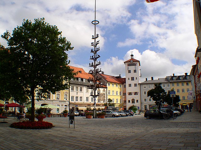
Kitzbühel
- municipality in Tyrol, Austria
Hiking in Kitzbühel
Kitzbühel, located in the Austrian Alps, is a spectacular destination for hiking enthusiasts. Known for its picturesque landscapes, charming town, and fantastic trails, Kitzbühel offers a variety of hiking options suitable for all levels, from beginners to experienced trekkers....
- Country:
- Postal Code: 6370
- Local Dialing Code: 05356
- Licence Plate Code: KB
- Coordinates: 47° 26' 47" N, 12° 23' 31" E
- GPS tracks (wikiloc): [Link]
- AboveSeaLevel: 762 м m
- Area: 58.02 sq km
- Population: 8272
- Web site: [Link]

Hochfilzen
- municipality in Austria
Hiking in Hochfilzen
Hochfilzen, located in the Tyrol region of Austria, is a picturesque village known for its stunning landscapes and outdoor activities, including hiking. Nestled in the foothills of the Alps, it offers a range of trails catering to different skill levels, making it an ideal destination for both novice and experienced hikers....
- Country:
- Postal Code: 6395
- Local Dialing Code: 05359
- Licence Plate Code: KB
- Coordinates: 47° 28' 10" N, 12° 37' 21" E
- GPS tracks (wikiloc): [Link]
- AboveSeaLevel: 959 м m
- Area: 32.7 sq km
- Population: 1196
- Web site: [Link]

Reith bei Kitzbühel
- municipality in Austria
Hiking in Reith bei Kitzbühel
Reith bei Kitzbühel, located in the Tyrol region of Austria, is a great destination for hiking enthusiasts. Nestled in the stunning Kitzbühel Alps, this area offers a mix of beautiful landscapes, charming villages, and a variety of trails that cater to all levels of hikers....
- Country:
- Local Dialing Code: 05356
- Licence Plate Code: KB
- Coordinates: 47° 28' 33" N, 12° 20' 40" E
- GPS tracks (wikiloc): [Link]
- AboveSeaLevel: 762 м m
- Area: 15.66 sq km
- Population: 1662
- Web site: [Link]


Kössen
- municipality in Austria
Hiking in Kössen
Kössen is a picturesque village located in the Tyrol region of Austria, surrounded by stunning Alpine landscapes, making it a fantastic destination for hiking enthusiasts. Here are some highlights and tips for hiking in Kössen:...
- Country:
- Postal Code: 6345
- Local Dialing Code: 05375
- Licence Plate Code: KB
- Coordinates: 47° 40' 7" N, 12° 24' 16" E
- GPS tracks (wikiloc): [Link]
- AboveSeaLevel: 589 м m
- Area: 69.34 sq km
- Population: 4346
- Web site: [Link]

Kirchdorf in Tirol
- municipality in Austria
Hiking in Kirchdorf in Tirol
Kirchdorf in Tirol is a beautiful village located in the Kitzbühel Alps region of Austria, making it an excellent destination for hiking enthusiasts. This area offers a variety of hiking trails that cater to different skill levels, from gentle walks suitable for families to challenging mountain ascents for experienced hikers....
- Country:
- Postal Code: 6382
- Local Dialing Code: 05352
- Licence Plate Code: KB
- Coordinates: 47° 33' 30" N, 12° 26' 51" E
- GPS tracks (wikiloc): [Link]
- AboveSeaLevel: 641 м m
- Area: 113.82 sq km
- Population: 3936
- Web site: [Link]

Going am Wilden Kaiser
- municipality in Austria
Hiking in Going am Wilden Kaiser
Going am Wilden Kaiser, a picturesque village in Austria's Tyrol region, serves as an excellent base for hiking enthusiasts. Nestled at the foot of the imposing Wilder Kaiser mountain range, it offers a variety of trails that cater to all skill levels, from leisurely walks to challenging hikes....
- Country:
- Postal Code: 6353
- Local Dialing Code: 05358
- Coordinates: 47° 30' 52" N, 12° 19' 41" E
- GPS tracks (wikiloc): [Link]
- AboveSeaLevel: 772 м m
- Area: 20.58 sq km
- Population: 1869
- Web site: [Link]

Kirchberg in Tirol
- municipality in Tyrol, Austria
Hiking in Kirchberg in Tirol
Kirchberg in Tirol is a beautiful destination for hiking enthusiasts, located in the Tyrol region of Austria. Nestled in the Kitzbühel Alps, it offers a stunning landscape featuring majestic mountains, lush valleys, and scenic alpine meadows....
- Country:
- Postal Code: 6365
- Local Dialing Code: 05357
- Licence Plate Code: KB
- Coordinates: 47° 27' 0" N, 12° 19' 0" E
- GPS tracks (wikiloc): [Link]
- AboveSeaLevel: 837 м m
- Area: 97.76 sq km
- Population: 5245
- Web site: [Link]

Waidring
- municipality in Austria
Hiking in Waidring
Waidring is a charming village located in the Tyrolean region of Austria, offering a variety of hiking opportunities set against the stunning backdrop of the Alps. Here's what you need to know about hiking in Waidring:...
- Country:
- Postal Code: 6384
- Local Dialing Code: 05353
- Licence Plate Code: KB
- Coordinates: 47° 34' 0" N, 12° 34' 0" E
- GPS tracks (wikiloc): [Link]
- AboveSeaLevel: 778 м m
- Area: 63.75 sq km
- Population: 2019
- Web site: [Link]


Oberndorf in Tirol
- municipality in Austria
Hiking in Oberndorf in Tirol
Oberndorf in Tirol is a picturesque village in the Tyrol region of Austria, nestled at the foot of the Kitzbühel Alps. It is an excellent destination for hiking enthusiasts, offering a variety of trails that cater to different skill levels....
- Country:
- Postal Code: 6372
- Local Dialing Code: 05352
- Licence Plate Code: KB
- Coordinates: 47° 29' 55" N, 12° 23' 5" E
- GPS tracks (wikiloc): [Link]
- AboveSeaLevel: 687 м m
- Area: 17.7 sq km
- Population: 2194
- Web site: [Link]

Hopfgarten im Brixental
- municipality in Austria
Hiking in Hopfgarten im Brixental
Hopfgarten im Brixental, located in the Tyrol region of Austria, is a fantastic destination for hiking enthusiasts. Nestled in the scenic Brixen Valley, it offers a variety of trails that showcase the stunning alpine landscape, making it suitable for hikers of all skill levels....
- Country:
- Postal Code: 6361
- Local Dialing Code: 05335
- Licence Plate Code: KB
- Coordinates: 47° 27' 0" N, 12° 10' 0" E
- GPS tracks (wikiloc): [Link]
- AboveSeaLevel: 622 м m
- Area: 166.55 sq km
- Population: 5677
- Web site: [Link]

Schwendt
- municipality in Austria
Hiking in Schwendt
Schwendt is a charming village located in the Tyrol region of Austria, near the larger town of Kufstein. It's known for its stunning landscapes, beautiful trails, and a mix of natural beauty and local culture, making it a great spot for hiking enthusiasts....
- Country:
- Postal Code: 6385
- Local Dialing Code: 05375
- Licence Plate Code: KB
- Coordinates: 47° 38' 0" N, 12° 24' 0" E
- GPS tracks (wikiloc): [Link]
- AboveSeaLevel: 702 м m
- Area: 30.84 sq km
- Population: 823
- Web site: [Link]


Itter
- municipality in Austria
Hiking in Itter
Itter is a picturesque village located in the Tyrol region of Austria, known for its stunning mountain views and outdoor activities, making it an ideal destination for hiking enthusiasts. Here are some highlights and tips for hiking in Itter:...
- Country:
- Postal Code: 6305
- Local Dialing Code: 05335
- Licence Plate Code: KB
- Coordinates: 47° 28' 14" N, 12° 8' 38" E
- GPS tracks (wikiloc): [Link]
- AboveSeaLevel: 703 м m
- Area: 10.44 sq km
- Population: 1150
- Web site: [Link]


Westendorf, Tyrol
- municipality in Austria
Hiking in Westendorf, Tyrol
Westendorf, located in the Tyrolean region of Austria, is a fantastic destination for hiking enthusiasts. Nestled in the stunning Kitzbühel Alps, it offers a diverse range of trails that cater to all levels of hikers, from beginners to experienced trekkers....
- Country:
- Postal Code: 6363
- Local Dialing Code: 05334
- Licence Plate Code: KB
- Coordinates: 47° 24' 0" N, 12° 12' 0" E
- GPS tracks (wikiloc): [Link]
- AboveSeaLevel: 783 м m
- Area: 95.52 sq km
- Population: 3652
- Web site: [Link]

Fieberbrunn
- municipality in Austria
Hiking in Fieberbrunn
Fieberbrunn is a charming village in the Tyrolean region of Austria, known for its stunning alpine scenery and outdoor recreational opportunities, especially hiking. Here are some highlights about hiking in Fieberbrunn:...
- Country:
- Postal Code: 6391
- Local Dialing Code: 05354
- Licence Plate Code: KB
- Coordinates: 47° 27' 59" N, 12° 33' 0" E
- GPS tracks (wikiloc): [Link]
- AboveSeaLevel: 790 м m
- Area: 76.29 sq km
- Population: 4287
- Web site: [Link]

Sankt Jakob in Haus
- municipality in Austria
Hiking in Sankt Jakob in Haus
Sankt Jakob in Haus is a charming village located in the Tyrol region of Austria, nestled in the picturesque Pillerseetal valley. It serves as an excellent base for outdoor enthusiasts, particularly hikers looking to explore the breathtaking landscapes of the surrounding Alps....
- Country:
- Postal Code: 6392
- Local Dialing Code: 05354
- Licence Plate Code: KB
- Coordinates: 47° 30' 3" N, 12° 33' 35" E
- GPS tracks (wikiloc): [Link]
- AboveSeaLevel: 855 м m
- Area: 9.61 sq km
- Population: 791
- Web site: [Link]
Jochberg
- municipality in Austria
Hiking in Jochberg
Jochberg is a charming village located in the Kitzbühel Alps of Tyrol, Austria. It’s known for its stunning alpine scenery, making it a fantastic destination for hiking enthusiasts of all levels. Here are some key points to consider when hiking in and around Jochberg:...
- Country:
- Postal Code: 6373
- Local Dialing Code: 05355
- Licence Plate Code: KB
- Coordinates: 47° 18' 0" N, 12° 25' 0" E
- GPS tracks (wikiloc): [Link]
- AboveSeaLevel: 923 м m
- Area: 87.8 sq km
- Population: 1577
- Web site: [Link]

St. Johann in Tirol
- municipality in Austria
Hiking in St. Johann in Tirol
St. Johann in Tirol is a beautiful village located in the Tyrol region of Austria, surrounded by stunning mountainous landscapes and offering a variety of hiking opportunities for all skill levels. Here are some highlights and tips for hiking in this area:...
- Country:
- Postal Code: 6380
- Local Dialing Code: 05352
- Licence Plate Code: KB
- Coordinates: 47° 31' 21" N, 12° 25' 32" E
- GPS tracks (wikiloc): [Link]
- AboveSeaLevel: 659 м m
- Area: 59.15 sq km
- Population: 9428
- Web site: [Link]


Sankt Ulrich am Pillersee
- municipality in Austria
Hiking in Sankt Ulrich am Pillersee
Sankt Ulrich am Pillersee is a picturesque village located in the Tyrol region of Austria, nestled in the Pillersee Valley. It offers a variety of hiking opportunities that cater to different skill levels, making it an excellent destination for both beginners and experienced hikers....
- Country:
- Postal Code: 6393
- Local Dialing Code: 05354
- Licence Plate Code: KB
- Coordinates: 47° 31' 0" N, 12° 34' 0" E
- GPS tracks (wikiloc): [Link]
- AboveSeaLevel: 847 м m
- Area: 52.01 sq km
- Population: 1819
- Web site: [Link]

Aurach bei Kitzbühel
- municipality in Austria
Hiking in Aurach bei Kitzbühel
Aurach bei Kitzbühel is a picturesque village located in the Tyrol region of Austria, nestled near the famous Kitzbühel ski resort. The area offers a variety of hiking opportunities that cater to different skill levels and preferences, surrounded by stunning mountain scenery....
- Country:
- Postal Code: 6371
- Local Dialing Code: 05356
- Licence Plate Code: KB
- Coordinates: 47° 25' 0" N, 12° 26' 0" E
- GPS tracks (wikiloc): [Link]
- AboveSeaLevel: 846 м m
- Area: 54.2 sq km
- Population: 1130
- Web site: [Link]

Brixen im Thale
- municipality in Austria
Hiking in Brixen im Thale
Brixen im Thale, located in the Tyrol region of Austria, is a fantastic destination for hiking enthusiasts. Nestled in the heart of the Kitzbüheler Alps, it offers a variety of trails that cater to all skill levels, from leisurely walks to more challenging treks. Here are some highlights and tips for hiking in this beautiful area:...
- Country:
- Postal Code: 6364
- Local Dialing Code: 05334
- Licence Plate Code: KB
- Coordinates: 47° 27' 0" N, 12° 15' 0" E
- GPS tracks (wikiloc): [Link]
- AboveSeaLevel: 794 м m
- Area: 31.38 sq km
- Population: 2639
- Web site: [Link]
Shares border with regions:
Traunstein
- district of Bavaria, Germany
Hiking in Traunstein
Traunstein, located in Bavaria, Germany, is a beautiful area known for its picturesque landscapes, charming villages, and a variety of hiking opportunities. The region is characterized by its rolling hills, mountains, and lakes, making it ideal for outdoor enthusiasts. Here are some highlights for hiking in Traunstein:...
- Country:

- Capital: Traunstein
- Licence Plate Code: TS
- Coordinates: 47° 53' 24" N, 12° 34' 48" E
- GPS tracks (wikiloc): [Link]
- AboveSeaLevel: 560 м m
- Area: 1533.92 sq km
- Population: 145408
- Web site: [Link]