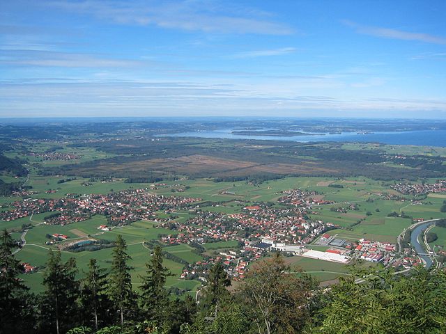
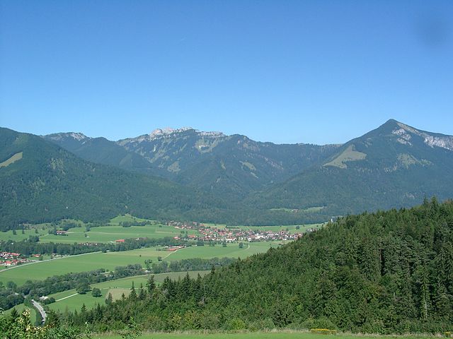
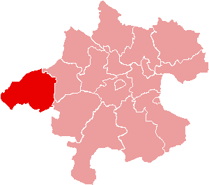
Traunstein (Landkreis Traunstein)

- district of Bavaria, Germany
 Hiking in Traunstein
Traunstein, located in Bavaria, Germany, is a beautiful area known for its picturesque landscapes, charming villages, and a variety of hiking opportunities. The region is characterized by its rolling hills, mountains, and lakes, making it ideal for outdoor enthusiasts. Here are some highlights for hiking in Traunstein:
Scenic Trails
-
Chiemsee Loop Trail: This scenic trail takes you around Bavaria's largest lake, the Chiemsee. You can enjoy stunning views of the water and the Alps, as well as the charming lakeside villages.
-
Priener Kopf: A popular hike that leads to the summit of Priener Kopf, offering panoramic views of Chiemsee and the surrounding mountains. The trail is suitable for various skill levels.
-
Hiking to the Alps: Traunstein serves as a gateway to the Alps. There are numerous trails leading to higher elevations, allowing hikers to experience alpine flora and fauna.
Nature and Wildlife
The region is rich in biodiversity, and hikers may encounter various wildlife, including deer, foxes, and a variety of birds. The natural beauty of the area is enhanced by numerous lakes, including the tranquil Traunsee, and rivers, providing perfect spots for breaks and picnics.
Cultural Experiences
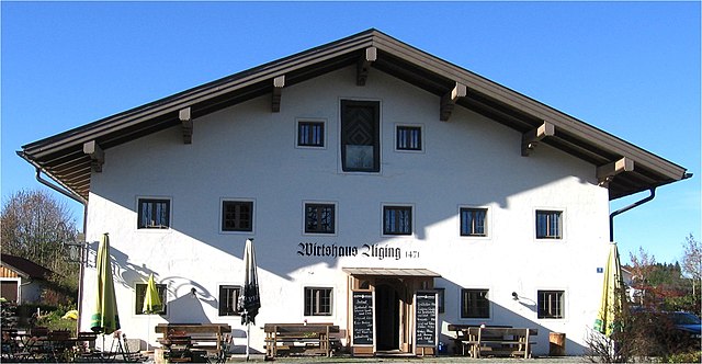
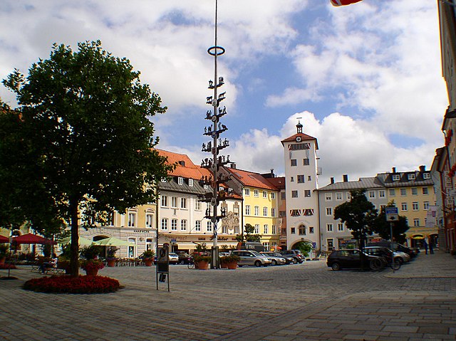
While hiking, you’ll also have an opportunity to explore the cultural heritage of the area. Quaint villages, traditional Bavarian architecture, and local cuisine can enhance your hiking experience. Don’t miss trying regional specialties at local restaurants or cafes.
Accessibility
Traunstein is accessible via public transportation, making it easy to reach various trailheads. The Bavarian Railways and local buses can take you to popular hiking spots, and there are many signed trails to follow.
Best Time to Hike
The ideal time for hiking in Traunstein is during late spring to early autumn (May to September). During this time, the weather is generally mild, the trails are well-maintained, and the landscapes are vibrant with flora.
Tips for Hikers
- Always check the weather before heading out and dress appropriately.
- Carry enough water, snacks, and a first-aid kit.
- Inform someone about your hiking plans, especially if you plan to venture into more remote areas.
- Respect nature and follow local guidelines to preserve the beauty of the trails.
Whether you're a seasoned hiker or a beginner, Traunstein offers a variety of trails and experiences that celebrate the stunning Bavarian landscape. Enjoy your adventure!
- Country:

- Capital: Traunstein
- Licence Plate Code: TS
- Coordinates: 47° 53' 24" N, 12° 34' 48" E


- GPS tracks (wikiloc): [Link]
- AboveSeaLevel: 560 м m
- Area: 1533.92 sq km
- Population: 145408
- Web site: http://www.traunstein.com/
- Wikipedia en: wiki(en)
- Wikipedia: wiki(de)
- Wikidata storage: Wikidata: Q10528
- Wikipedia Commons Category: [Link]
- Wikipedia Commons Maps Category: [Link]
- Freebase ID: [/m/02jks3]
- GeoNames ID: Alt: [3220841]
- VIAF ID: Alt: [242988564]
- OSM relation ID: [2156363]
- GND ID: Alt: [4060758-6]
- archINFORM location ID: [4640]
- Quora topic ID: [Traunstein]
- TGN ID: [7077289]
- Historical Gazetteer (GOV) ID: [adm_139189]
- Bavarikon ID: [ODB_A00002362]
- ISNI: Alt: [0000 0004 0581 6973]
- NUTS code: [DE21M]
- Ringgold ID: [37095]
- German district key: 09189
Includes regions:

Petting
- municipality of Germany
Hiking in Petting
Petting, a small village in Bavaria, Germany, serves as a picturesque base for outdoor enthusiasts looking to explore the beautiful landscapes of the region. While not as widely known as some of Bavaria's larger tourist destinations, Petting offers a peaceful atmosphere and access to scenic hiking trails....
- Country:
- Postal Code: 83367
- Local Dialing Code: 08686
- Licence Plate Code: TS
- Coordinates: 47° 55' 0" N, 12° 49' 0" E
- GPS tracks (wikiloc): [Link]
- AboveSeaLevel: 451 м m
- Area: 29.93 sq km
- Population: 1891
- Web site: [Link]

Waginger See
- unincorporated area in Germany
Hiking in Waginger See
Waginger See, located in Bavaria, Germany, is a picturesque lake surrounded by stunning landscapes, making it an excellent destination for hiking enthusiasts. Here are some key points to consider for hiking in the area around Waginger See:...
- Country:
- Coordinates: 47° 56' 19" N, 12° 46' 39" E
- GPS tracks (wikiloc): [Link]
Grassau
- municipality of Germany
Hiking in Grassau
Grassau is a picturesque village located in Bavaria, Germany, surrounded by stunning natural landscapes that are perfect for hiking enthusiasts. The area is known for its rolling hills, scenic lakes, and breathtaking views of the Alps, making it an excellent destination for outdoor activities....
- Country:
- Postal Code: 83224
- Local Dialing Code: 08641
- Licence Plate Code: TS
- Coordinates: 47° 46' 44" N, 12° 27' 0" E
- GPS tracks (wikiloc): [Link]
- AboveSeaLevel: 538 м m
- Area: 35.76 sq km
- Population: 5383
- Web site: [Link]
Kienberg, Bavaria
- municipality of Germany
Hiking in Kienberg, Bavaria
Kienberg, located in Bavaria, Germany, is a great destination for hiking enthusiasts. The area offers a mix of scenic landscapes, diverse trails, and a rich cultural backdrop, making it ideal for both casual walkers and experienced hikers....
- Country:
- Postal Code: 83361
- Local Dialing Code: 08628
- Licence Plate Code: TS
- Coordinates: 48° 2' 0" N, 12° 28' 0" E
- GPS tracks (wikiloc): [Link]
- AboveSeaLevel: 559 м m
- Area: 22.83 sq km
- Population: 1115
- Web site: [Link]

Seeon-Seebruck
- municipality in Traunstein, Bavaria, Germany
Hiking in Seeon-Seebruck
Seeon-Seebruck, located in Bavaria, Germany, is a delightful area for hiking enthusiasts. Nestled between beautiful lakes and lush landscapes, it offers a variety of trails that cater to different skill levels. Here are some highlights for hiking in this region:...
- Country:
- Postal Code: 83376; 83371; 83370; 83358
- Local Dialing Code: 08667
- Licence Plate Code: TS
- Coordinates: 47° 58' 0" N, 12° 28' 0" E
- GPS tracks (wikiloc): [Link]
- AboveSeaLevel: 537 м m
- Area: 47.92 sq km
- Population: 4575
- Web site: [Link]
Nußdorf
- municipality of Germany
Hiking in Nußdorf
Nußdorf am Inn, located in the Chiemgau region of Bavaria, Germany, offers a picturesque setting for hiking enthusiasts. This charming village is nestled between beautiful landscapes, including rolling hills, lush forests, and panoramic views of the Alps and the nearby Chiemsee, one of the largest lakes in Germany....
- Country:
- Postal Code: 83365
- Local Dialing Code: 08669
- Licence Plate Code: TS
- Coordinates: 47° 53' 0" N, 12° 35' 0" E
- GPS tracks (wikiloc): [Link]
- AboveSeaLevel: 603 м m
- Area: 16.12 sq km
- Population: 1768
- Web site: [Link]

Surberg
- municipality of Germany
Hiking in Surberg
Surberg, a small municipality located in Bavaria, Germany, offers a variety of hiking opportunities amidst beautiful landscapes. The region is characterized by rolling hills, lush forests, and charming villages, making it an ideal spot for both novice and experienced hikers....
- Country:
- Postal Code: 83362
- Local Dialing Code: 08666; 08662; 0861
- Licence Plate Code: TS
- Coordinates: 47° 52' 0" N, 12° 42' 0" E
- GPS tracks (wikiloc): [Link]
- AboveSeaLevel: 650 м m
- Area: 23.71 sq km
- Population: 2823
- Web site: [Link]

Inzell
- municipality of Germany
Hiking in Inzell
Inzell, located in Bavaria, Germany, is a charming village nestled within the picturesque Alps. It’s known for its stunning landscapes, making it an excellent destination for hiking enthusiasts. Here are some key points about hiking in Inzell:...
- Country:
- Postal Code: 83334
- Local Dialing Code: 08665
- Licence Plate Code: TS
- Coordinates: 47° 46' 0" N, 12° 45' 0" E
- GPS tracks (wikiloc): [Link]
- AboveSeaLevel: 693 м m
- Area: 45.35 sq km
- Population: 3736
- Web site: [Link]

Reit im Winkl
- municipality of Germany
Hiking in Reit im Winkl
Reit im Winkl is a beautiful village located in Bavaria, Germany, and is renowned for its stunning alpine scenery and a wide variety of hiking trails. Here’s an overview of hiking in this picturesque area:...
- Country:
- Postal Code: 83242
- Local Dialing Code: 08640
- Licence Plate Code: TS
- Coordinates: 47° 40' 41" N, 12° 28' 12" E
- GPS tracks (wikiloc): [Link]
- AboveSeaLevel: 696 м m
- Area: 70.99 sq km
- Population: 2363
- Web site: [Link]

Staudach-Egerndach
- municipality of Germany
Hiking in Staudach-Egerndach
Staudach-Egerndach is a charming village located in the picturesque region of Bavaria, Germany, near the Alps. It offers a variety of hiking opportunities that cater to different skill levels, making it an excellent destination for both casual walkers and experienced hikers....
- Country:
- Postal Code: 83224
- Local Dialing Code: 08641
- Licence Plate Code: TS
- Coordinates: 47° 47' 0" N, 12° 29' 0" E
- GPS tracks (wikiloc): [Link]
- AboveSeaLevel: 540 м m
- Area: 19.34 sq km
- Population: 1046
- Web site: [Link]
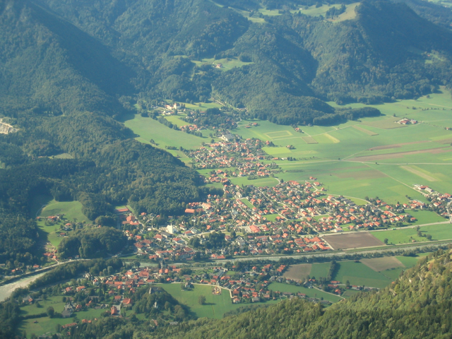
Traunstein
- town in Bavaria, Germany
Hiking in Traunstein
Traunstein is a beautiful area in Bavaria, Germany, known for its stunning natural landscapes, offering a variety of hiking trails suitable for all levels of hikers. Located near the Traunsee lake and surrounded by the impressive peaks of the Alps, hiking in Traunstein provides breathtaking views, lush forests, and serene lakes....
- Country:
- Postal Code: 83278
- Local Dialing Code: 0861
- Licence Plate Code: TS
- Coordinates: 47° 52' 0" N, 12° 38' 0" E
- GPS tracks (wikiloc): [Link]
- AboveSeaLevel: 591 м m
- Area: 48.53 sq km
- Population: 20172
- Web site: [Link]

Taching am See
- municipality of Germany
Hiking in Taching am See
Taching am See is a picturesque village located in Bavaria, Germany, near the shores of Lake Tachinger See. It offers beautiful landscapes, lush greenery, and opportunities for outdoor activities, making it an ideal destination for hiking enthusiasts....
- Country:
- Postal Code: 83373
- Local Dialing Code: 08681
- Licence Plate Code: TS
- Coordinates: 47° 57' 34" N, 12° 43' 46" E
- GPS tracks (wikiloc): [Link]
- AboveSeaLevel: 478 м m
- Area: 26.76 sq km
- Population: 1657
- Web site: [Link]

Pittenhart
- municipality of Germany
Hiking in Pittenhart
Pittenhart is a small village in Bavaria, Germany, offering a tranquil setting that can be great for hiking enthusiasts. While it may not be as widely known as some larger hiking destinations, the surrounding area provides several trails and natural beauty worth exploring. Here are some points to consider if you plan to hike in and around Pittenhart:...
- Country:
- Postal Code: 83132
- Local Dialing Code: 08624
- Licence Plate Code: TS
- Coordinates: 47° 59' 0" N, 12° 23' 0" E
- GPS tracks (wikiloc): [Link]
- AboveSeaLevel: 564 м m
- Area: 27.93 sq km
- Population: 1320
- Web site: [Link]

Obing
- municipality of Germany
Hiking in Obing
Obing, located in Bavaria, Germany, is a delightful area for hiking enthusiasts. It is surrounded by picturesque landscapes, including lush rolling hills, forests, and scenic lakes. Here are some key points to consider if you are planning a hiking trip in and around Obing:...
- Country:
- Postal Code: 83119
- Local Dialing Code: 08624
- Licence Plate Code: TS
- Coordinates: 48° 0' 0" N, 12° 25' 0" E
- GPS tracks (wikiloc): [Link]
- AboveSeaLevel: 562 м m
- Area: 43.75 sq km
- Population: 3226
- Web site: [Link]

Grabenstätt
- municipality of Germany
Hiking in Grabenstätt
Grabenstätt, located in Bavaria, Germany, is an excellent base for hiking enthusiasts due to its picturesque landscapes and proximity to the Chiemsee, one of the largest lakes in Germany. The region offers a variety of hiking trails suitable for all skill levels, from easy lakeside strolls to more challenging mountain hikes....
- Country:
- Postal Code: 83355
- Local Dialing Code: 08661
- Licence Plate Code: TS
- Coordinates: 47° 50' 38" N, 12° 32' 33" E
- GPS tracks (wikiloc): [Link]
- AboveSeaLevel: 526 м m
- Area: 37.81 sq km
- Population: 3145
- Web site: [Link]

Chieming
- municipality of Germany
Hiking in Chieming
Chieming, located on the eastern shore of Lake Chiemsee in Bavaria, Germany, is a picturesque village that serves as a great base for hiking enthusiasts. The region is known for its stunning natural landscapes, including mountains, forests, and the beautiful lake itself. Here are some highlights and tips for hiking in and around Chieming:...
- Country:
- Postal Code: 83339
- Local Dialing Code: 08664
- Licence Plate Code: TS
- Coordinates: 47° 54' 0" N, 12° 32' 0" E
- GPS tracks (wikiloc): [Link]
- AboveSeaLevel: 537 м m
- Area: 37.73 sq km
- Population: 4827
- Web site: [Link]
Traunreut
- town in Bavaria, Germany
Hiking in Traunreut
Traunreut, located in the Bavaria region of Germany, offers access to beautiful hiking trails that showcase the scenic beauty of the surrounding landscape, including the nearby foothills of the Alps and numerous lakes....
- Country:
- Postal Code: 83301
- Local Dialing Code: 08669
- Licence Plate Code: TS
- Coordinates: 47° 58' 0" N, 12° 35' 0" E
- GPS tracks (wikiloc): [Link]
- AboveSeaLevel: 572 м m
- Area: 45.05 sq km
- Population: 19278
- Web site: [Link]

Übersee
- municipality of Germany
Hiking in Übersee
Übersee, a picturesque village located in Bavaria, Germany, offers beautiful hiking opportunities, particularly in the stunning foothills of the Alps near Lake Chiemsee. Here are some highlights and tips for hiking in the Übersee area:...
- Country:
- Postal Code: 83236
- Local Dialing Code: 08642
- Licence Plate Code: TS
- Coordinates: 47° 49' 0" N, 12° 28' 0" E
- GPS tracks (wikiloc): [Link]
- AboveSeaLevel: 526 м m
- Area: 30.53 sq km
- Population: 3787
- Web site: [Link]
Schleching
- municipality of Germany
Hiking in Schleching
Schleching is a charming village in Bavaria, Germany, located in the foothills of the Alps, making it a fantastic destination for hiking enthusiasts. The area is known for its stunning natural landscapes, including lush valleys, river systems, and breathtaking views of the surrounding mountains....
- Country:
- Postal Code: 83259
- Local Dialing Code: 08649
- Licence Plate Code: TS
- Coordinates: 47° 43' 0" N, 12° 24' 0" E
- GPS tracks (wikiloc): [Link]
- AboveSeaLevel: 569 м m
- Area: 45.17 sq km
- Population: 1494
- Web site: [Link]
Vachendorf
- municipality of Germany
Hiking in Vachendorf
Vachendorf is a picturesque village located in the Bavaria region of Germany, near the Alps. It's surrounded by stunning landscapes, making it an excellent destination for hiking enthusiasts. Here are some highlights of hiking in Vachendorf:...
- Country:
- Postal Code: 83377
- Local Dialing Code: 0861
- Licence Plate Code: TS
- Coordinates: 47° 51' 0" N, 12° 37' 0" E
- GPS tracks (wikiloc): [Link]
- AboveSeaLevel: 581 м m
- Area: 9.96 sq km
- Population: 1481
- Web site: [Link]

Fridolfing
- municipality of Germany
Hiking in Fridolfing
Fridolfing is a small municipality located in Bavaria, Germany, near the border with Austria. While it may not be as widely known as other hiking destinations, it offers some charming natural landscapes and opportunities for outdoor activities. Here are some points to consider when hiking in and around Fridolfing:...
- Country:
- Postal Code: 83413
- Local Dialing Code: 08684
- Licence Plate Code: TS
- Coordinates: 48° 0' 0" N, 12° 49' 0" E
- GPS tracks (wikiloc): [Link]
- AboveSeaLevel: 388 м m
- Area: 44.22 sq km
- Population: 3326
- Web site: [Link]

Waging am See
- municipality in the district of Traunstein in Bavaria, Germany.
Hiking in Waging am See
Waging am See is a picturesque town in Bavaria, Germany, known for its beautiful landscapes, serene lake, and extensive hiking opportunities. Here’s an overview of what you can expect when hiking in this lovely area:...
- Country:
- Postal Code: 83329
- Local Dialing Code: 08681
- Licence Plate Code: TS
- Coordinates: 47° 56' 0" N, 12° 44' 0" E
- GPS tracks (wikiloc): [Link]
- AboveSeaLevel: 465 м m
- Area: 48.86 sq km
- Population: 5317
- Web site: [Link]

Palling
- municipality of Germany
Hiking in Palling
Palling, located in Bavaria, Germany, offers some beautiful hiking opportunities amidst stunning natural landscapes. While not as well-known as some other hiking destinations in Germany, it provides a peaceful environment that is perfect for outdoor enthusiasts looking for less crowded trails....
- Country:
- Postal Code: 83349
- Local Dialing Code: 08629
- Licence Plate Code: TS
- Coordinates: 48° 0' 0" N, 12° 38' 0" E
- GPS tracks (wikiloc): [Link]
- AboveSeaLevel: 531 м m
- Area: 53.83 sq km
- Population: 2905
- Web site: [Link]

Bergen, Upper Bavaria
- municipality in the district of Traunstein in Bavaria, Germany
Hiking in Bergen, Upper Bavaria
Bergen, located in Upper Bavaria, Germany, is a charming town surrounded by stunning natural landscapes, making it a great destination for hiking enthusiasts. The region is characterized by its picturesque mountains, lush forests, and beautiful lakes, providing a variety of trails suitable for all skill levels....
- Country:
- Postal Code: 83346
- Local Dialing Code: 08662
- Licence Plate Code: TS
- Coordinates: 47° 49' 0" N, 12° 36' 0" E
- GPS tracks (wikiloc): [Link]
- AboveSeaLevel: 553 м m
- Area: 36.91 sq km
- Population: 3542
- Web site: [Link]

Kirchanschöring
- municipality of Germany
Hiking in Kirchanschöring
Kirchanschöring is a scenic area located in Bavaria, Germany, offering a range of hiking opportunities through the beautiful Bavarian countryside. Here are some highlights about hiking in and around Kirchanschöring:...
- Country:
- Postal Code: 83417
- Local Dialing Code: 08685
- Licence Plate Code: TS
- Coordinates: 47° 57' 0" N, 12° 50' 0" E
- GPS tracks (wikiloc): [Link]
- AboveSeaLevel: 417 м m
- Area: 25.23 sq km
- Population: 2577
- Web site: [Link]

Siegsdorf
- municipality of Germany
Hiking in Siegsdorf
Siegsdorf is a picturesque village located in Bavaria, Germany, surrounded by stunning landscapes and the majestic Alps. It offers numerous hiking opportunities for both beginners and experienced hikers. Here are some highlights about hiking in Siegsdorf:...
- Country:
- Postal Code: 83313
- Local Dialing Code: 08662
- Licence Plate Code: TS
- Coordinates: 47° 49' 0" N, 12° 39' 0" E
- GPS tracks (wikiloc): [Link]
- AboveSeaLevel: 615 м m
- Area: 55.20 sq km
- Population: 7219
- Web site: [Link]
Marquartstein
- municipality in Bavaria, Germany
Hiking in Marquartstein
Marquartstein, located in Bavaria, Germany, is a picturesque village nestled in the foothills of the Alps and is a great destination for hiking enthusiasts. Here are some highlights and recommendations for hiking in the area:...
- Country:
- Postal Code: 83250
- Local Dialing Code: 08641
- Licence Plate Code: TS
- Coordinates: 47° 45' 31" N, 12° 27' 42" E
- GPS tracks (wikiloc): [Link]
- AboveSeaLevel: 545 м m
- Area: 13.41 sq km
- Population: 2665
- Web site: [Link]

Altenmarkt an der Alz
- municipality of Germany
Hiking in Altenmarkt an der Alz
Altenmarkt an der Alz, located in Bavaria, Germany, is an excellent destination for hiking enthusiasts. Nestled near the banks of the Alz River and surrounded by scenic landscapes, the area offers a variety of trails suitable for hikers of all levels....
- Country:
- Postal Code: 83352
- Local Dialing Code: 08621
- Licence Plate Code: TS
- Coordinates: 48° 0' 0" N, 12° 31' 0" E
- GPS tracks (wikiloc): [Link]
- AboveSeaLevel: 499 м m
- Area: 26.10 sq km
- Population: 3151
- Web site: [Link]

Schnaitsee
- municipality of Germany
Hiking in Schnaitsee
Schnaitsee is a picturesque village located in Bavaria, Germany, known for its stunning landscapes, serene lakes, and a variety of hiking trails. The area around Schnaitsee offers outdoor enthusiasts plenty of opportunities to explore nature, enjoy the fresh air, and appreciate the beautiful Bavarian countryside....
- Country:
- Postal Code: 83530
- Local Dialing Code: 08074
- Licence Plate Code: TS
- Coordinates: 48° 4' 0" N, 12° 22' 0" E
- GPS tracks (wikiloc): [Link]
- AboveSeaLevel: 608 м m
- Area: 61.14 sq km
- Population: 3020
- Web site: [Link]

Trostberg
- town in Bavaria, Germany
Hiking in Trostberg
Trostberg, located in the beautiful region of Bavaria, Germany, offers a variety of hiking opportunities that cater to different skill levels and preferences. Nestled near the banks of the Salzach River, the area is renowned for its picturesque landscapes, charming villages, and rich history....
- Country:
- Postal Code: 83308
- Local Dialing Code: 08621
- Licence Plate Code: TS
- Coordinates: 48° 1' 0" N, 12° 33' 0" E
- GPS tracks (wikiloc): [Link]
- AboveSeaLevel: 493 м m
- Area: 51.36 sq km
- Population: 10251
- Web site: [Link]

Tittmoning
- town in Bavaria, Germany
Hiking in Tittmoning
Tittmoning, located in Bavaria, Germany, is a charming town set against the backdrop of the picturesque Chiemgau Alps, making it an attractive destination for hikers. The region offers a variety of trails catering to different skill levels, from leisurely walks to more challenging hikes....
- Country:
- Postal Code: 84529
- Local Dialing Code: 08683
- Licence Plate Code: TS
- Coordinates: 48° 3' 47" N, 12° 46' 1" E
- GPS tracks (wikiloc): [Link]
- AboveSeaLevel: 388 м m
- Area: 72.01 sq km
- Population: 4947
- Web site: [Link]
Engelsberg
- municipality of Germany
Hiking in Engelsberg
Engelsberg is a picturesque village located in the Dalarna region of Sweden. It's surrounded by stunning natural landscapes, making it a wonderful destination for hiking enthusiasts. Here are a few highlights and tips for hiking in and around Engelsberg:...
- Country:
- Postal Code: 84549
- Local Dialing Code: 08634
- Licence Plate Code: TS
- Coordinates: 48° 7' 0" N, 12° 33' 0" E
- GPS tracks (wikiloc): [Link]
- AboveSeaLevel: 517 м m
- Area: 34.18 sq km
- Population: 1847
- Web site: [Link]

Wonneberg
- municipality of Germany
Hiking in Wonneberg
Wonneberg is a picturesque village located in Bavaria, Germany, surrounded by stunning natural landscapes that are ideal for hiking enthusiasts. The area boasts a variety of trails suitable for different skill levels, making it accessible to both beginners and experienced hikers. Here are some highlights of hiking in Wonneberg:...
- Country:
- Postal Code: 83379
- Local Dialing Code: 08681
- Licence Plate Code: TS
- Coordinates: 47° 55' 0" N, 12° 43' 0" E
- GPS tracks (wikiloc): [Link]
- AboveSeaLevel: 575 м m
- Area: 18.01 sq km
- Population: 1143
- Web site: [Link]

Unterwössen
- municipality of Germany
Hiking in Unterwössen
Unterwössen is a charming village located in the foothills of the Alps in Bavaria, Germany. It offers a variety of hiking opportunities ideal for both beginners and experienced hikers who want to experience the magnificent natural landscapes of the region....
- Country:
- Postal Code: 83246
- Local Dialing Code: 0 86 41
- Licence Plate Code: TS
- Coordinates: 47° 44' 0" N, 12° 28' 0" E
- GPS tracks (wikiloc): [Link]
- AboveSeaLevel: 555 м m
- Area: 41.28 sq km
- Population: 2752
- Web site: [Link]

Tacherting
- municipality of Germany
Hiking in Tacherting
Tacherting, located in Bavaria, Germany, offers several wonderful hiking opportunities for outdoor enthusiasts. The region is characterized by its picturesque landscapes, including rolling hills, forests, and meadows, making it an ideal location for hiking. Here are some key points to consider when planning a hike in Tacherting:...
- Country:
- Postal Code: 83340–83342
- Local Dialing Code: 08634; 08622; 08621
- Licence Plate Code: TS
- Coordinates: 48° 5' 0" N, 12° 34' 0" E
- GPS tracks (wikiloc): [Link]
- AboveSeaLevel: 473 м m
- Area: 50.24 sq km
- Population: 4388
- Web site: [Link]

Chiemsee
- municipality of Germany
Hiking in Chiemsee
Chiemsee, located in Bavaria, Germany, is a beautiful area particularly known for its stunning lake, Chiemsee, which is often referred to as the "Bavarian Sea" due to its size. The region offers a variety of hiking opportunities, making it a popular destination for outdoor enthusiasts....
- Country:
- Postal Code: 83256
- Local Dialing Code: 08054
- Licence Plate Code: RO
- Coordinates: 47° 52' 0" N, 12° 25' 0" E
- GPS tracks (wikiloc): [Link]
- AboveSeaLevel: 523 м m
- Area: 2.57 sq km
- Population: 431
- Web site: [Link]

Ruhpolding
- municipality of Bavaria, Germany
Hiking in Ruhpolding
Ruhpolding, located in the Bavarian Alps of Germany, is a beautiful destination for hiking enthusiasts. Surrounded by stunning mountain landscapes, lush valleys, and crystal-clear streams, it offers a variety of hiking trails suitable for all levels, from beginners to more experienced trekkers....
- Country:
- Postal Code: 83324
- Local Dialing Code: 08663
- Licence Plate Code: TS
- Coordinates: 47° 46' 0" N, 12° 39' 0" E
- GPS tracks (wikiloc): [Link]
- AboveSeaLevel: 799 м m
- Area: 147.83 sq km
- Population: 7010
- Web site: [Link]
Shares border with regions:

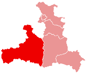
Rosenheim
- district of Bavaria, Germany
Hiking in Rosenheim
Rosenheim district, located in Bavaria, Germany, offers a diverse range of hiking opportunities amidst beautiful landscapes, charming villages, and stunning natural scenery. Here are some highlights for hiking in the region:...
- Country:
- Capital: Rosenheim
- Licence Plate Code: WS; RO; AIB
- Coordinates: 47° 55' 12" N, 12° 10' 12" E
- GPS tracks (wikiloc): [Link]
- AboveSeaLevel: 512 м m
- Area: 1439.40 sq km
- Population: 190104
- Web site: [Link]

Berchtesgadener Land
- district of Bavaria, Germany
Hiking in Berchtesgadener Land
Berchtesgadener Land is a stunning region in Bavaria, Germany, known for its breathtaking landscapes, towering mountains, lush valleys, and crystal-clear lakes. It’s a hiker’s paradise with trails suitable for all levels of experience. Here are some highlights and tips for hiking in this beautiful area:...
- Country:
- Capital: Bad Reichenhall
- Licence Plate Code: BGL
- Coordinates: 47° 44' 0" N, 12° 53' 0" E
- GPS tracks (wikiloc): [Link]
- AboveSeaLevel: 465 м m
- Area: 840.00 sq km
- Population: 90689
- Web site: [Link]

Altötting
- district of Bavaria, Germany
Hiking in Altötting
Altötting, located in Bavaria, Germany, is known for its historical significance as a pilgrimage site, but it also offers beautiful landscapes ideal for hiking enthusiasts. Here are some key highlights about hiking in the Altötting district:...
- Country:
- Capital: Altötting
- Licence Plate Code: AÖ
- Coordinates: 48° 15' 0" N, 12° 45' 0" E
- GPS tracks (wikiloc): [Link]
- AboveSeaLevel: 436 м m
- Area: 569.41 sq km
- Population: 94216
- Web site: [Link]

Mühldorf
- district of Bavaria, Germany
Hiking in Mühldorf
Mühldorf District, located in Bavaria, Germany, offers a range of hiking opportunities that cater to different skill levels and preferences. The area features scenic landscapes, including rolling hills, forests, and rivers, making it an attractive destination for nature lovers and outdoor enthusiasts....
- Country:
- Capital: Mühldorf
- Licence Plate Code: MÜ
- Coordinates: 48° 15' 0" N, 12° 25' 12" E
- GPS tracks (wikiloc): [Link]
- AboveSeaLevel: 447 м m
- Area: 805.32 sq km
- Population: 92882

Kufstein District
- district of Austria
Hiking in Kufstein District
The Kufstein District, located in the federal state of Tyrol, Austria, is a fantastic area for hiking enthusiasts. It features stunning alpine landscapes, charming villages, and well-established trails that cater to various skill levels....
- Country:

- Capital: Kufstein
- Licence Plate Code: KU
- Coordinates: 47° 30' 0" N, 12° 6' 0" E
- GPS tracks (wikiloc): [Link]
- AboveSeaLevel: 646 м m
- Area: 969.90 sq km
- Population: 105466
- Web site: [Link]


Salzburg-Umgebung District
- district in Austria
Hiking in Salzburg-Umgebung District
Salzburg-Umgebung District, located in the Austrian state of Salzburg, is a fantastic destination for hiking enthusiasts. The region offers a diverse range of trails that cater to all skill levels, from leisurely walks to challenging mountain hikes. Here are some highlights and recommendations for hiking in this beautiful area:...
- Country:
- Capital: Salzburg
- Licence Plate Code: SL
- Coordinates: 47° 52' 1" N, 13° 4' 59" E
- GPS tracks (wikiloc): [Link]
- AboveSeaLevel: 624 м m
- Area: 1004.36 sq km
- Population: 148738
- Web site: [Link]
Braunau am Inn District
- district of Austria
Hiking in Braunau am Inn District
Braunau am Inn District, located in Austria near the border with Germany, offers a variety of hiking opportunities that cater to different skill levels and preferences. The landscape is characterized by rolling hills, lush greenery, and scenic views, making it an attractive destination for nature lovers and outdoor enthusiasts....
- Country:
- Capital: Braunau am Inn
- Licence Plate Code: BR
- Coordinates: 48° 7' 52" N, 13° 6' 32" E
- GPS tracks (wikiloc): [Link]
- AboveSeaLevel: 451 м m
- Area: 1040.38 sq km
- Web site: [Link]

Zell am See District
- district of Austria
Hiking in Zell am See District
Zell am See District, located in the beautiful Austrian state of Salzburg, is a fantastic destination for hiking enthusiasts. The area is known for its stunning alpine scenery, including the crystal-clear Lake Zell, majestic mountains, and lush green valleys. Here are some highlights and tips for hiking in this picturesque region:...
- Country:
- Capital: Zell am See
- Licence Plate Code: ZE
- Coordinates: 47° 21' 0" N, 12° 42' 0" E
- GPS tracks (wikiloc): [Link]
- AboveSeaLevel: 761 м m
- Area: 2640.85 sq km
- Population: 86441
- Web site: [Link]

Kitzbühel District
- district of Austria
Hiking in Kitzbühel District
Kitzbühel District, located in the Tyrol region of Austria, is a stunning destination for hiking enthusiasts. With its majestic mountains, lush valleys, and picturesque alpine villages, it offers a variety of hiking trails suitable for all levels, from beginners to experienced trekkers....
- Country:
- Capital: Kitzbühel
- Licence Plate Code: KB
- Coordinates: 47° 30' 0" N, 12° 24' 0" E
- GPS tracks (wikiloc): [Link]
- AboveSeaLevel: 1085 м m
- Area: 1163.28 sq km
- Population: 63125
- Web site: [Link]