La Chapelle-Saint-Martin-en-Plaine (La Chapelle-Saint-Martin-en-Plaine)

- commune in Loir-et-Cher, France
- Country:

- Postal Code: 41500
- Coordinates: 47° 43' 2" N, 1° 24' 59" E


- GPS tracks (wikiloc): [Link]
- Area: 22.83 sq km
- Population: 724
- Wikipedia en: wiki(en)
- Wikipedia: wiki(fr)
- Wikidata storage: Wikidata: Q1157686
- Wikipedia Commons Category: [Link]
- Freebase ID: [/m/03nv_9z]
- GeoNames ID: Alt: [3010268]
- SIREN number: [214100398]
- BnF ID: [152593158]
- INSEE municipality code: 41039
Shares border with regions:


Suèvres
- commune in Loir-et-Cher, France
- Country:
- Postal Code: 41500
- Coordinates: 47° 40' 0" N, 1° 27' 39" E
- GPS tracks (wikiloc): [Link]
- Area: 36.65 sq km
- Population: 1673


La Madeleine-Villefrouin
- commune in Loir-et-Cher, France
- Country:
- Postal Code: 41370
- Coordinates: 47° 47' 8" N, 1° 24' 48" E
- GPS tracks (wikiloc): [Link]
- AboveSeaLevel: 115 м m
- Area: 9.68 sq km
- Population: 30

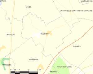
Mulsans
- commune in Loir-et-Cher, France
- Country:
- Postal Code: 41500
- Coordinates: 47° 41' 46" N, 1° 23' 6" E
- GPS tracks (wikiloc): [Link]
- Area: 16 sq km
- Population: 509


Villexanton
- commune in Loir-et-Cher, France
- Country:
- Postal Code: 41500
- Coordinates: 47° 44' 29" N, 1° 25' 19" E
- GPS tracks (wikiloc): [Link]
- Area: 11.53 sq km
- Population: 200

Mer
- commune in Loir-et-Cher, France
- Country:
- Postal Code: 41500
- Coordinates: 47° 41' 55" N, 1° 30' 28" E
- GPS tracks (wikiloc): [Link]
- Area: 26.47 sq km
- Population: 6202
- Web site: [Link]


Talcy
- commune in Loir-et-Cher, France
- Country:
- Postal Code: 41370
- Coordinates: 47° 46' 8" N, 1° 26' 37" E
- GPS tracks (wikiloc): [Link]
- Area: 15.21 sq km
- Population: 252


Maves
- commune in Loir-et-Cher, France
- Country:
- Postal Code: 41500
- Coordinates: 47° 44' 32" N, 1° 21' 52" E
- GPS tracks (wikiloc): [Link]
- Area: 33.33 sq km
- Population: 662
- Web site: [Link]