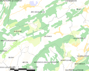
La Chaux (La Chaux)
- commune in Doubs, France
La Chaux is a picturesque region in the Doubs department of France, known for its stunning natural landscapes, including rolling hills, dense forests, and scenic viewpoints. It's a great destination for hiking enthusiasts of all levels. Here are some key points to consider when hiking in La Chaux:
Hiking Trails
- Local Trails: Several well-marked trails cater to various skill levels. Trails often lead to breathtaking viewpoints, such as those overlooking the Doubs River or the surrounding Jura Mountains.
- GR Trails: The area is part of the Grande Randonnée (GR) network, with long-distance trails that can be explored for multi-day hikes.
- Theme Trails: Some trails may emphasize local flora, fauna, or historical aspects of the region, offering hikers a chance to learn while enjoying nature.
Natural Attractions
- Forests: The region is lush with beech and fir trees, providing plenty of shade and a serene hiking experience.
- Lakes and Rivers: The Doubs River runs through the area, and visitors may also explore nearby lakes, perfect for a break or a picnic.
- Wildlife: Keep an eye out for deer, various bird species, and other wildlife native to the Jura region.
Practical Tips
- Maps and Guides: It's advisable to carry a detailed map or use a hiking app for navigation, especially if you're venturing on less-known paths.
- Weather Conditions: Check the local weather forecast before heading out, as conditions can change rapidly in mountainous regions.
- Gear Recommendations: Wear sturdy hiking boots, comfortable clothing, and consider bringing trekking poles for steeper trails. Don't forget essentials like water, snacks, and sunscreen.
- Respect Nature: Follow Leave No Trace principles; pack out what you pack in and stay on marked trails to protect the environment.
Accessibility and Nearby Attractions
La Chaux is accessible by car and has parking facilities. Nearby towns may offer accommodations, dining options, and other activities like cycling and sightseeing in the Jura Mountains.
Whether you're looking for a peaceful day hike or a challenging multi-day trek, La Chaux in Doubs provides a beautiful setting for outdoor adventure. Always be prepared, and enjoy the natural beauty of the region!
- Country:

- Postal Code: 25650
- Coordinates: 47° 1' 23" N, 6° 25' 57" E


- GPS tracks (wikiloc): [Link]
- Area: 16.94 sq km
- Population: 497
- Wikipedia en: wiki(en)
- Wikipedia: wiki(fr)
- Wikidata storage: Wikidata: Q773186
- Wikipedia Commons Category: [Link]
- Freebase ID: [/m/03mgs2x]
- Freebase ID: [/m/03mgs2x]
- GeoNames ID: Alt: [6615098]
- GeoNames ID: Alt: [6615098]
- SIREN number: [212501399]
- SIREN number: [212501399]
- BnF ID: [152523654]
- BnF ID: [152523654]
- INSEE municipality code: 25139
- INSEE municipality code: 25139
Shares border with regions:


Gilley
- commune in Doubs, France
Gilley is a charming village located in the Doubs department of the Bourgogne-Franche-Comté region in eastern France. It’s a great spot for hiking enthusiasts, offering picturesque landscapes, lush forests, and scenic views of the surrounding Jura mountains....
- Country:

- Postal Code: 25650
- Coordinates: 47° 2' 51" N, 6° 29' 4" E


- GPS tracks (wikiloc): [Link]
- Area: 17.27 sq km
- Population: 1615
- Web site: [Link]


Ouhans
- commune in Doubs, France
Ouhans is a charming village located in the Franche-Comté region of France, surrounded by the stunning landscapes of the Jura Mountains. This area offers a variety of hiking opportunities suitable for different skill levels, making it a great destination for hikers....
- Country:

- Postal Code: 25520
- Coordinates: 46° 59' 54" N, 6° 17' 37" E


- GPS tracks (wikiloc): [Link]
- Area: 15.85 sq km
- Population: 373


Montflovin
- commune in Doubs, France
Montflovin is a small village located in the Jura Mountains of France, known for its stunning landscapes and outdoor recreational opportunities. Hiking in this area offers a great experience for both seasoned hikers and beginners, with various trails that cater to different skill levels....
- Country:

- Postal Code: 25650
- Coordinates: 46° 59' 11" N, 6° 26' 42" E


- GPS tracks (wikiloc): [Link]
- Area: 3.35 sq km
- Population: 100

