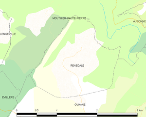
Ouhans (Ouhans)

- commune in Doubs, France
 Hiking in Ouhans
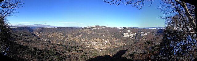
Ouhans is a charming village located in the Franche-Comté region of France, surrounded by the stunning landscapes of the Jura Mountains. This area offers a variety of hiking opportunities suitable for different skill levels, making it a great destination for hikers.
Hiking Trails and Highlights:
-
Scenic Views: The trails around Ouhans provide breathtaking views of the surrounding valleys, forests, and Jura peaks. Look out for lookout points that offer panoramic views of the region.
-
Nature Exploration: The region is rich in biodiversity, with various flora and fauna. You might encounter limestone cliffs, dense forests, and picturesque meadows, making it a great spot for nature lovers.
-
Cascades and Waterfalls: Some trails may lead you to beautiful waterfalls, adding a refreshing element to your hike.
-
Local Culture and History: As you hike, you'll have the chance to explore the local culture and history. Look for old farms, traditional houses, and perhaps even remnants of historical significance.
-
Trail Difficulty: There are trails for all levels, from easy walks suitable for families to more challenging hikes for experienced hikers. Ensure you choose a trail appropriate for your fitness and experience level.
Tips for Hiking in Ouhans:
- Weather: Check the weather forecast before heading out, as conditions in the Jura mountains can change rapidly.
- Gear Up: Wear appropriate hiking gear, including sturdy boots, and bring water, snacks, and a first-aid kit.
- Trail Maps: Consider obtaining a map or guidebook for the area, which can often be found in local tourist information centers.
- Respect Nature: Stay on marked trails and follow Leave No Trace principles to help preserve the natural beauty of the area.
Additional Activities:
- Caving: The Jura region is known for its caves. If you're interested in adventure beyond hiking, you might explore a cave in the vicinity.
- Cycling: The region is also bicycle-friendly, offering trails that cater to cyclists.
Ouhans, with its stunning natural surroundings and peaceful atmosphere, is a wonderful place for hiking enthusiasts looking to explore the great outdoors in France. Enjoy your hike!
- Country:

- Postal Code: 25520
- Coordinates: 46° 59' 54" N, 6° 17' 37" E


- GPS tracks (wikiloc): [Link]
- Area: 15.85 sq km
- Population: 373
- Wikipedia en: wiki(en)
- Wikipedia: wiki(fr)
- Wikidata storage: Wikidata: Q777521
- Wikipedia Commons Category: [Link]
- Freebase ID: [/m/03mgy0d]
- Freebase ID: [/m/03mgy0d]
- GeoNames ID: Alt: [6429928]
- GeoNames ID: Alt: [6429928]
- SIREN number: [212504401]
- SIREN number: [212504401]
- BnF ID: [152526669]
- BnF ID: [152526669]
- MusicBrainz area ID: [440e6b6e-42c4-4dd5-99b8-0049e7a33204]
- MusicBrainz area ID: [440e6b6e-42c4-4dd5-99b8-0049e7a33204]
- INSEE municipality code: 25440
- INSEE municipality code: 25440
Shares border with regions:


Évillers
- commune in Doubs, France
Hiking in Évillers
Évillers is a charming commune located in the Doubs department of the Bourgogne-Franche-Comté region in eastern France. It is surrounded by beautiful natural landscapes, making it an ideal destination for hiking enthusiasts....
- Country:
- Postal Code: 25520
- Coordinates: 47° 0' 0" N, 6° 13' 33" E
- GPS tracks (wikiloc): [Link]
- Area: 13.02 sq km
- Population: 346

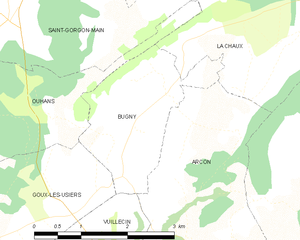
Bugny
- commune in Doubs, France
Hiking in Bugny
It seems like you may have meant "Buny" or "Bugny," but I couldn't find specific information on a hiking destination by that exact name. However, if you're referring to a particular area or region, many places with similar names can offer great hiking opportunities....
- Country:
- Postal Code: 25520
- Coordinates: 46° 59' 41" N, 6° 21' 12" E
- GPS tracks (wikiloc): [Link]
- Area: 4.77 sq km
- Population: 218

Aubonne
- commune in Doubs, France
Hiking in Aubonne
Aubonne, located in the Doubs department of France, offers a serene environment perfect for hiking enthusiasts. The region is characterized by its stunning landscapes, including hilly terrains, dense forests, and picturesque views of the surrounding countryside....
- Country:
- Postal Code: 25520
- Coordinates: 47° 2' 10" N, 6° 19' 43" E
- GPS tracks (wikiloc): [Link]
- Area: 15.17 sq km
- Population: 239

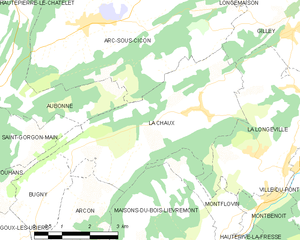
La Chaux
- commune in Doubs, France
Hiking in La Chaux
La Chaux is a picturesque region in the Doubs department of France, known for its stunning natural landscapes, including rolling hills, dense forests, and scenic viewpoints. It's a great destination for hiking enthusiasts of all levels. Here are some key points to consider when hiking in La Chaux:...
- Country:
- Postal Code: 25650
- Coordinates: 47° 1' 23" N, 6° 25' 57" E
- GPS tracks (wikiloc): [Link]
- Area: 16.94 sq km
- Population: 497


Mouthier-Haute-Pierre
- commune in Doubs, France
Hiking in Mouthier-Haute-Pierre
Mouthier-Haute-Pierre is a picturesque village nestled in the Jura Mountains of eastern France. It's known for its beautiful natural landscapes, making it a fantastic destination for hiking enthusiasts. Here are some highlights and tips for hiking in the area:...
- Country:
- Postal Code: 25920
- Coordinates: 47° 2' 20" N, 6° 16' 33" E
- GPS tracks (wikiloc): [Link]
- Area: 12.13 sq km
- Population: 320
- Web site: [Link]


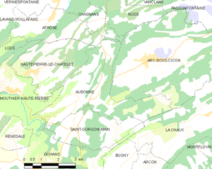
Saint-Gorgon-Main
- commune in Doubs, France
Hiking in Saint-Gorgon-Main
Saint-Gorgon-Main is located in the Auvergne-Rhône-Alpes region of France, nearby the beautiful landscapes of the French Alps. While it's a less-known area compared to major hiking destinations, it offers some splendid opportunities for outdoor enthusiasts....
- Country:
- Postal Code: 25520
- Coordinates: 47° 1' 22" N, 6° 19' 24" E
- GPS tracks (wikiloc): [Link]
- Area: 7.93 sq km
- Population: 284


Goux-les-Usiers
- commune in Doubs, France
Hiking in Goux-les-Usiers
Goux-les-Usiers, located in the Franche-Comté region of eastern France, is a charming destination for hiking enthusiasts. Nestled in the Doubs department, it offers stunning natural landscapes, including rolling hills, lush forests, and scenic waterways....
- Country:
- Postal Code: 25520
- Coordinates: 46° 58' 18" N, 6° 16' 40" E
- GPS tracks (wikiloc): [Link]
- Area: 17.63 sq km
- Population: 722
Renédale
- commune in Doubs, France
Hiking in Renédale
Renédale is not a well-known hiking destination, and I don't have specific information about it as of my last update in October 2023. However, if there's a location called Renédale that has emerged or gained popularity recently, you might want to check local hiking guides, websites, or social media for the latest information and trail reviews....
- Country:
- Postal Code: 25520
- Coordinates: 47° 1' 4" N, 6° 16' 39" E
- GPS tracks (wikiloc): [Link]
- Area: 2.88 sq km
- Population: 41