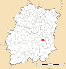
La Ferté-Alais (La Ferté-Alais)
- commune in Essonne, France
- Country:

- Postal Code: 91590
- Coordinates: 48° 28' 58" N, 2° 20' 55" E


- GPS tracks (wikiloc): [Link]
- Area: 4.55 sq km
- Population: 3909
- Web site: http://www.lafertealais.fr
- Wikipedia en: wiki(en)
- Wikipedia: wiki(fr)
- Wikidata storage: Wikidata: Q821256
- Wikipedia Commons Category: [Link]
- Freebase ID: [/m/01mqws]
- Freebase ID: [/m/01mqws]
- GeoNames ID: Alt: [3009496]
- GeoNames ID: Alt: [3009496]
- SIREN number: [219102324]
- SIREN number: [219102324]
- BnF ID: [15280120r]
- BnF ID: [15280120r]
- VIAF ID: Alt: [143351951]
- VIAF ID: Alt: [143351951]
- Library of Congress authority ID: Alt: [n96053375]
- Library of Congress authority ID: Alt: [n96053375]
- PACTOLS thesaurus ID: [pcrt07bKdd0mGB]
- PACTOLS thesaurus ID: [pcrt07bKdd0mGB]
- MusicBrainz area ID: [c2b6fb38-4223-4816-99d4-c4539be54d3d]
- MusicBrainz area ID: [c2b6fb38-4223-4816-99d4-c4539be54d3d]
- INSEE municipality code: 91232
- INSEE municipality code: 91232
- US National Archives Identifier: 10037853
- US National Archives Identifier: 10037853
Shares border with regions:


Baulne
- commune in Essonne, France
- Country:

- Postal Code: 91590
- Coordinates: 48° 29' 32" N, 2° 21' 35" E


- GPS tracks (wikiloc): [Link]
- Area: 8.17 sq km
- Population: 1311


D'Huison-Longueville
- commune in Essonne, France
- Country:

- Postal Code: 91590
- Coordinates: 48° 27' 29" N, 2° 19' 14" E


- GPS tracks (wikiloc): [Link]
- Area: 10.04 sq km
- Population: 1500
- Web site: [Link]


Guigneville-sur-Essonne
- commune in Essonne, France
- Country:

- Postal Code: 91590
- Coordinates: 48° 28' 30" N, 2° 21' 16" E


- GPS tracks (wikiloc): [Link]
- Area: 9.19 sq km
- Population: 968
- Web site: [Link]


Videlles
- commune in Essonne, France
- Country:

- Postal Code: 91890
- Coordinates: 48° 27' 52" N, 2° 25' 53" E


- GPS tracks (wikiloc): [Link]
- Area: 8.7 sq km
- Population: 601


Cerny
- commune in Essonne, France
- Country:

- Postal Code: 91590
- Coordinates: 48° 28' 37" N, 2° 19' 41" E


- GPS tracks (wikiloc): [Link]
- Area: 17.13 sq km
- Population: 3319
- Web site: [Link]
