La Fouillouse (La Fouillouse)

- commune in Loire, France
- Country:

- Postal Code: 42480
- Coordinates: 45° 30' 14" N, 4° 18' 49" E


- GPS tracks (wikiloc): [Link]
- Area: 20.57 sq km
- Population: 4383
- Web site: http://www.lafouillouse.fr
- Wikipedia en: wiki(en)
- Wikipedia: wiki(fr)
- Wikidata storage: Wikidata: Q1066057
- Wikipedia Commons Category: [Link]
- Freebase ID: [/m/03nw8j4]
- Freebase ID: [/m/03nw8j4]
- GeoNames ID: Alt: [6614537]
- GeoNames ID: Alt: [6614537]
- SIREN number: [214200974]
- SIREN number: [214200974]
- BnF ID: [152596660]
- BnF ID: [152596660]
- INSEE municipality code: 42097
- INSEE municipality code: 42097
Shares border with regions:


L'Étrat
- commune in Loire, France
- Country:
- Postal Code: 42580
- Coordinates: 45° 29' 8" N, 4° 22' 45" E
- GPS tracks (wikiloc): [Link]
- Area: 8.48 sq km
- Population: 2595
- Web site: [Link]

Andrézieux-Bouthéon
- commune in Loire, France
- Country:
- Postal Code: 42160
- Coordinates: 45° 31' 34" N, 4° 15' 37" E
- GPS tracks (wikiloc): [Link]
- Area: 16.28 sq km
- Population: 9947
- Web site: [Link]

Villars
- commune in Loire, France
- Country:
- Postal Code: 42390
- Coordinates: 45° 28' 8" N, 4° 21' 16" E
- GPS tracks (wikiloc): [Link]
- Area: 5.72 sq km
- Population: 8016
- Web site: [Link]


Saint-Just-Saint-Rambert
- commune in Loire, France
- Country:
- Postal Code: 42170
- Coordinates: 45° 29' 59" N, 4° 14' 29" E
- GPS tracks (wikiloc): [Link]
- AboveSeaLevel: 417 м m
- Area: 40.63 sq km
- Population: 14935
- Web site: [Link]


Saint-Héand
- commune in Loire, France
- Country:
- Postal Code: 42570
- Coordinates: 45° 31' 43" N, 4° 22' 22" E
- GPS tracks (wikiloc): [Link]
- Area: 31.3 sq km
- Population: 3600
- Web site: [Link]

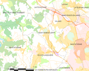
Saint-Genest-Lerpt
- commune in Loire, France
- Country:
- Postal Code: 42530
- Coordinates: 45° 26' 46" N, 4° 20' 12" E
- GPS tracks (wikiloc): [Link]
- Area: 12.68 sq km
- Population: 6112
- Web site: [Link]

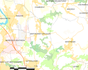
Saint-Bonnet-les-Oules
- commune in Loire, France
- Country:
- Postal Code: 42330
- Coordinates: 45° 32' 33" N, 4° 19' 55" E
- GPS tracks (wikiloc): [Link]
- Area: 12.41 sq km
- Population: 1585
- Web site: [Link]