La Mancellière-sur-Vire (La Mancellière-sur-Vire)

- former commune in Manche, France
- Country:

- Postal Code: 50750
- Coordinates: 49° 4' 8" N, 1° 4' 13" E


- GPS tracks (wikiloc): [Link]
- Area: 6.8 sq km
- Population: 496
- Wikipedia en: wiki(en)
- Wikipedia: wiki(fr)
- Wikidata storage: Wikidata: Q641802
- Wikipedia Commons Category: [Link]
- Freebase ID: [/m/0h31dc]
- Freebase ID: [/m/0h31dc]
- GeoNames ID: Alt: [3008316]
- GeoNames ID: Alt: [3008316]
- BnF ID: [152622621]
- BnF ID: [152622621]
- INSEE municipality code: 50287
- INSEE municipality code: 50287
Shares border with regions:


Condé-sur-Vire
- former commune in Manche, France
- Country:
- Postal Code: 50890
- Coordinates: 49° 3' 8" N, 1° 2' 14" E
- GPS tracks (wikiloc): [Link]
- Area: 24.85 sq km
- Population: 3382
- Web site: [Link]

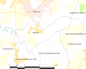
Baudre
- commune in Manche, France
- Country:
- Postal Code: 50000
- Coordinates: 49° 5' 21" N, 1° 4' 23" E
- GPS tracks (wikiloc): [Link]
- Area: 3.81 sq km
- Population: 544
- Web site: [Link]

Sainte-Suzanne-sur-Vire
- commune in Manche, France
- Country:
- Postal Code: 50750
- Coordinates: 49° 3' 43" N, 1° 3' 34" E
- GPS tracks (wikiloc): [Link]
- Area: 5.05 sq km
- Population: 674
- Web site: [Link]

Saint-Romphaire
- former commune in Manche, France
- Country:
- Postal Code: 50750
- Coordinates: 49° 2' 20" N, 1° 6' 21" E
- GPS tracks (wikiloc): [Link]
- Area: 9.97 sq km
- Population: 738


Gourfaleur
- former commune in Manche, France
- Country:
- Postal Code: 50750
- Coordinates: 49° 4' 59" N, 1° 6' 44" E
- GPS tracks (wikiloc): [Link]
- Area: 8.45 sq km
- Population: 468