La Rochelle (La Rochelle)

- commune in Haute-Saône, France
- Country:

- Postal Code: 70120
- Coordinates: 47° 44' 47" N, 5° 43' 56" E


- GPS tracks (wikiloc): [Link]
- Area: 4.23 sq km
- Population: 41
- Wikipedia en: wiki(en)
- Wikipedia: wiki(fr)
- Wikidata storage: Wikidata: Q901852
- Wikipedia Commons Category: [Link]
- Freebase ID: [/m/03nvlnk]
- GeoNames ID: Alt: [6456371]
- SIREN number: [217004506]
- BnF ID: [152728428]
- MusicBrainz area ID: [3212880a-9a41-4d6f-9312-d4a58ca5154a]
- Facebook Places ID: [109370652426488]
- INSEE municipality code: 70450
Shares border with regions:


Pressigny
- commune in Haute-Marne, France
- Country:
- Postal Code: 52500
- Coordinates: 47° 44' 51" N, 5° 39' 51" E
- GPS tracks (wikiloc): [Link]
- Area: 22.61 sq km
- Population: 200
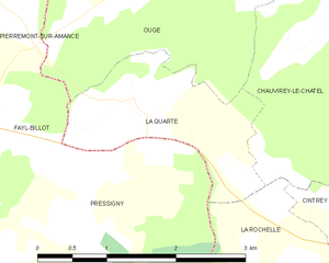
La Quarte
- commune in Haute-Saône, France
- Country:
- Postal Code: 70120
- Coordinates: 47° 46' 25" N, 5° 41' 42" E
- GPS tracks (wikiloc): [Link]
- Area: 3.19 sq km
- Population: 62
Cintrey
- commune in Haute-Saône, France
- Country:
- Postal Code: 70120
- Coordinates: 47° 45' 2" N, 5° 45' 20" E
- GPS tracks (wikiloc): [Link]
- Area: 6.08 sq km
- Population: 97


Chauvirey-le-Châtel
- commune in Haute-Saône, France
- Country:
- Postal Code: 70500
- Coordinates: 47° 47' 28" N, 5° 45' 17" E
- GPS tracks (wikiloc): [Link]
- Area: 11.76 sq km
- Population: 121


Molay
- commune in Haute-Saône, France
- Country:
- Postal Code: 70120
- Coordinates: 47° 43' 56" N, 5° 44' 28" E
- GPS tracks (wikiloc): [Link]
- AboveSeaLevel: 276 м m
- Area: 7.66 sq km
- Population: 68