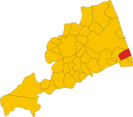
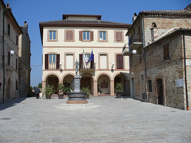
Lapedona (Lapedona)
.svg)
- Italian comune
 Hiking in Lapedona
Lapedona is a charming village located in the Marche region of Italy, known for its picturesque landscapes and natural beauty, making it a great destination for hiking enthusiasts. Here are some key points to consider if you plan to hike in or around Lapedona:
Scenic Trails
- Variety of Terrain: The areas surrounding Lapedona offer a mix of terrain, including hills, forests, and countryside, which provide various hiking experiences for different skill levels.
- Coastal Paths: Given its proximity to the Adriatic Sea, there are beautiful coastal trails that allow hikers to enjoy stunning sea views and diverse flora and fauna.
Local Nature
- Flora and Fauna: The region is rich in biodiversity, with opportunities to spot local wildlife and numerous plant species. The natural scenery is often complemented by charming rural landscapes, vineyards, and olive groves.
Cultural Experiences
- Historical Sites: Hiking in Lapedona also allows for cultural exploration. Many trails lead to historical sites, ancient ruins, or small villages, offering insights into the local history and architecture.
Accessibility
- Trail Markings: Many trails are well-marked, making it easier for both seasoned hikers and novices to navigate. It’s advisable to check local maps or apps for detailed trail information.
- Local Guides: Hiring a local guide can enhance your experience, as they can provide insights into the history, culture, and wildlife of the area.
Seasonal Considerations
- Best Time to Hike: Spring (April to June) and Fall (September to October) are ideal for hiking, given the mild temperatures and blooming landscapes. Summer can be hot, while winter may have limited hiking options due to snow or rain.
Preparation
- Gear: Make sure to wear appropriate hiking shoes and carry supplies like water, snacks, a first aid kit, and sunscreen.
- Weather: Always check the weather forecast before heading out, as conditions can change rapidly in mountainous areas.
Lapedona’s hiking opportunities provide a wonderful blend of nature, culture, and adventure, perfect for a memorable outdoor experience.
- Country:

- Postal Code: 63823
- Local Dialing Code: 0734
- Licence Plate Code: FM
- Coordinates: 43° 6' 35" N, 13° 46' 22" E


- GPS tracks (wikiloc): [Link]
- AboveSeaLevel: 264 м m
- Area: 14.93 sq km
- Population: 1189
- Web site: http://www.comunedilapedona.it
- Wikipedia en: wiki(en)
- Wikipedia: wiki(it)
- Wikidata storage: Wikidata: Q59232
- Wikipedia Commons Category: [Link]
- Freebase ID: [/m/0gl7z7]
- GeoNames ID: Alt: [6541072]
- VIAF ID: Alt: [236603755]
- OSM relation ID: [42315]
- WOEID: [717019]
- Google Maps Customer ID: [3569083782286349846]
- ISTAT ID: 109009
- Italian cadastre code: E447
Shares border with regions:


Fermo
- Italian comune
Hiking in Fermo
Fermo, located in the Marche region of Italy, offers a variety of hiking opportunities that showcase its stunning landscapes, historical sites, and charming countryside. Here are some highlights and tips for hiking in and around Fermo:...
- Country:
- Postal Code: 63900
- Local Dialing Code: 0734
- Licence Plate Code: FM
- Coordinates: 43° 9' 38" N, 13° 43' 5" E
- GPS tracks (wikiloc): [Link]
- AboveSeaLevel: 319 м m
- Area: 124.53 sq km
- Population: 37238
- Web site: [Link]


Montefiore dell'Aso
- Italian comune
Hiking in Montefiore dell'Aso
Montefiore dell'Aso is a charming hilltop village located in the Marche region of Italy, known for its beautiful landscapes, historical architecture, and a rich cultural heritage. Hiking in and around Montefiore dell'Aso offers a unique blend of natural beauty and cultural exploration....
- Country:
- Postal Code: 63062
- Local Dialing Code: 0734
- Licence Plate Code: AP
- Coordinates: 43° 3' 6" N, 13° 45' 5" E
- GPS tracks (wikiloc): [Link]
- AboveSeaLevel: 412 м m
- Area: 28.21 sq km
- Population: 2053
- Web site: [Link]

Altidona
- Italian comune
Hiking in Altidona
Altidona is a picturesque hilltop town located in the Marche region of Italy, known for its stunning views, medieval architecture, and beautiful natural surroundings. Hiking in and around Altidona can offer a wonderful combination of scenic vistas, cultural experiences, and opportunities to connect with nature. Here are some highlights for hiking in this area:...
- Country:
- Postal Code: 63824
- Local Dialing Code: 0734
- Licence Plate Code: FM
- Coordinates: 43° 6' 25" N, 13° 47' 38" E
- GPS tracks (wikiloc): [Link]
- AboveSeaLevel: 224 м m
- Area: 12.97 sq km
- Population: 3452
- Web site: [Link]

Campofilone
- Italian comune
Hiking in Campofilone
Campofilone is a charming town located in the province of Fermo in the Marche region of Italy. Known for its picturesque landscapes and traditional architecture, it offers some great opportunities for hiking enthusiasts who want to explore the natural beauty of the surrounding area....
- Country:
- Postal Code: 63828
- Local Dialing Code: 0734
- Licence Plate Code: FM
- Coordinates: 43° 4' 45" N, 13° 48' 52" E
- GPS tracks (wikiloc): [Link]
- AboveSeaLevel: 210 м m
- Area: 12.21 sq km
- Population: 1918
- Web site: [Link]


Monterubbiano
- Italian comune
Hiking in Monterubbiano
Monterubbiano is a charming hilltop town located in the Marche region of Italy, known for its scenic views, medieval architecture, and rich cultural heritage. Hiking around Monterubbiano offers opportunities to explore beautiful landscapes, quaint countryside, and historical sites....
- Country:
- Postal Code: 63825
- Local Dialing Code: 0734
- Licence Plate Code: FM
- Coordinates: 43° 5' 7" N, 13° 43' 0" E
- GPS tracks (wikiloc): [Link]
- AboveSeaLevel: 463 м m
- Area: 32.24 sq km
- Population: 2164
- Web site: [Link]


Moresco
- Italian comune
Hiking in Moresco
Moresco is a charming hilltop village located in the Marche region of Italy, known for its scenic views and rich history. Hiking in and around Moresco can be a delightful experience, as the area offers varied landscapes, including hills, valleys, and the coastal scenery of the Adriatic Sea....
- Country:
- Postal Code: 63826
- Local Dialing Code: 0734
- Licence Plate Code: FM
- Coordinates: 43° 5' 9" N, 13° 43' 55" E
- GPS tracks (wikiloc): [Link]
- AboveSeaLevel: 405 м m
- Area: 6.35 sq km
- Population: 576
- Web site: [Link]