Larnage (Larnage)
- commune in Drôme, France
Larnage, located in the Auvergne-Rhône-Alpes region of France, offers a variety of hiking opportunities that showcase the natural beauty of the countryside. Situated near the northern part of the Rhône valley, the area is characterized by rolling hills, vineyards, and picturesque landscapes.
Hiking Trails:
-
Local Trails: There are several marked hiking trails in and around Larnage that cater to different skill levels. These trails often take you through scenic vineyards, small forests, and rural pathways. Look for local trail maps, which can be found at tourist information centers or online.
-
Vineyard Routes: The surrounding vineyards provide excellent opportunities for combining hiking with wine tasting. Some paths lead directly through the vineyards, offering stunning views and the chance to learn about local wine production.
-
Nearby Natural Reserves: Consider venturing slightly further to explore larger natural parks or reserves in the region, like the Parc Naturel Régional du Vercors or the Monts d'Ardèche. These areas provide more extensive trails and varied terrain.
Preparation:
- Weather: Always check the local weather forecasts before your hike, as conditions can change quickly, especially in the hilly terrain.
- Gear: Wear comfortable hiking shoes and bring appropriate gear for the season, including sun protection, water, and snacks.
- Navigation: Familiarize yourself with the trails ahead of time. GPS apps or physical maps can be helpful as some trails may not be well-marked.
Local Tips:
- Best Time to Hike: Spring (April to June) and fall (September to October) are ideal for hiking in this region due to mild temperatures and beautiful scenery.
- Cultural Stops: Take time to explore the local culture. There may be small shops or markets in nearby villages where you can sample local produce and regional delicacies.
In summary, Larnage provides a delightful setting for hiking enthusiasts. Whether you're looking for a gentle stroll through vineyards or more challenging hikes, the area has a lot to offer. Enjoy your adventure!
- Country:

- Postal Code: 26600
- Coordinates: 45° 5' 49" N, 4° 51' 50" E


- GPS tracks (wikiloc): [Link]
- AboveSeaLevel: 247 м m
- Area: 9.08 sq km
- Population: 1071
- Wikipedia en: wiki(en)
- Wikipedia: wiki(fr)
- Wikidata storage: Wikidata: Q655387
- Wikipedia Commons Category: [Link]
- Freebase ID: [/m/03mgl1n]
- GeoNames ID: Alt: [6430106]
- SIREN number: [212601561]
- BnF ID: [15253017p]
- PACTOLS thesaurus ID: [pcrt1QlEYv35DS]
- INSEE municipality code: 26156
Shares border with regions:


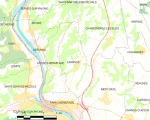
Tain-l'Hermitage, Drôme
- commune in Drôme, France
 Hiking in Tain-l'Hermitage, Drôme
Tain-l'Hermitage, located in the Rhône-Alpes region of France, is surrounded by beautiful landscapes and scenic trails that make it a great destination for hiking enthusiasts. Here are a few highlights and tips for hiking in the area:...
- Country:

- Postal Code: 26600
- Coordinates: 45° 4' 14" N, 4° 50' 33" E


- GPS tracks (wikiloc): [Link]
- Area: 4.85 sq km
- Population: 6100
- Web site: [Link]


Érôme
- commune in Drôme, France
- Country:

- Postal Code: 26600
- Coordinates: 45° 7' 12" N, 4° 49' 16" E


- GPS tracks (wikiloc): [Link]
- Area: 7.33 sq km
- Population: 824


Chantemerle-les-Blés
- commune in Drôme, France
 Hiking in Chantemerle-les-Blés
Chantemerle-les-Blés is a charming village located in the Drôme department of France, which is known for its beautiful landscapes and outdoor activities, including hiking. The region around Chantemerle-les-Blés offers a variety of hiking trails that cater to different skill levels, from leisurely walks to more challenging hikes....
- Country:

- Postal Code: 26600
- Coordinates: 45° 6' 38" N, 4° 53' 49" E


- GPS tracks (wikiloc): [Link]
- Area: 15.39 sq km
- Population: 1273


Crozes-Hermitage
- commune in Drôme, France
Crozes-Hermitage is a picturesque region in the northern Rhône Valley of France, renowned for its vineyards and stunning landscapes. Hiking in this area offers not only beautiful views of terraced vineyards but also access to charming villages and the natural beauty of the surrounding hills....
- Country:

- Postal Code: 26600
- Coordinates: 45° 5' 24" N, 4° 50' 45" E


- GPS tracks (wikiloc): [Link]
- Area: 5.48 sq km
- Population: 635
