Le Biot (Le Biot)

- commune in Haute-Savoie, France
 Hiking in Le Biot
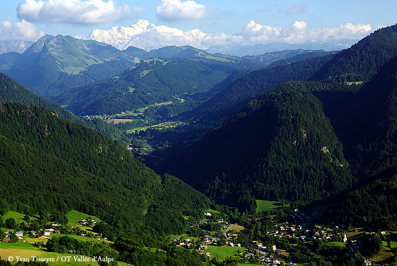
Le Biot is a charming village located in the Haute-Savoie region of France, nestled in the French Alps. It's a great destination for hikers due to its stunning natural scenery and variety of trails that cater to different skill levels. Here are some key points to consider when hiking in Le Biot:
Trails and Routes
- Variety of Trails: The region surrounding Le Biot offers a mix of easy walks, moderate hikes, and more challenging routes, making it suitable for all hiking enthusiasts.
- Beautiful Scenery: Hikers can enjoy breathtaking views of the surrounding mountains, lush valleys, and alpine meadows. The landscape is especially picturesque during the spring and summer months.
- Lac de Mines d'Or: A popular hiking destination is the trail leading to the Lac de Mines d'Or, which provides beautiful views and a chance to spot local wildlife.
- Les Chalets de Chenau: For a more challenging hike, consider making your way to Les Chalets de Chenau, where you can enjoy panoramic views of Mont Blanc and other peaks.
Best Times to Hike
- Spring to Autumn: The ideal time for hiking in Le Biot is from late spring to early autumn (May to October) when the weather is generally mild and the trails are accessible.
- Winter Adventures: In winter, the area transforms into a popular spot for snowshoeing and winter hiking, offering a completely different experience.
Essential Tips
- Weather Awareness: Always check the weather forecast before heading out, as conditions can change rapidly in the mountains.
- Proper Gear: Wear appropriate hiking boots, and bring sufficient water, snacks, and a first aid kit. Depending on the trail, poles can also be helpful.
- Trail Maps: It's advisable to carry a map or GPS device, as not all trails may be well-marked.
- Local Guidance: Consider hiring a local guide if you’re unfamiliar with the area or seeking a unique hiking experience.
Accommodations and Amenities
- Le Biot’s accommodations range from hotels to chalets, providing options for comfortable stays after a day of hiking. The local eateries also offer delicious mountain cuisine to refuel.
Whether you are looking for a leisurely stroll or a challenging trek, Le Biot offers varied hiking opportunities amidst the stunning backdrop of the French Alps. Always prioritize safety and be mindful of the environment while enjoying your hiking experience!
- Country:

- Postal Code: 74430
- Coordinates: 46° 15' 46" N, 6° 37' 57" E


- GPS tracks (wikiloc): [Link]
- Area: 13.18 sq km
- Population: 576
- Web site: http://www.lebiot.fr/Francais
- Wikipedia en: wiki(en)
- Wikipedia: wiki(fr)
- Wikidata storage: Wikidata: Q654161
- Wikipedia Commons Category: [Link]
- Freebase ID: [/m/03ntxy6]
- GeoNames ID: Alt: [6455419]
- SIREN number: [217400340]
- BnF ID: [15274294b]
- INSEE municipality code: 74034
Shares border with regions:


Abondance, Haute-Savoie
- commune in Haute-Savoie, France
Hiking in Abondance, Haute-Savoie
Abondance, located in the Haute-Savoie region of the French Alps, is a beautiful destination for hiking enthusiasts. This charming village is well-known for its stunning mountain landscapes, lush valleys, and rich cultural heritage....
- Country:
- Postal Code: 74360
- Coordinates: 46° 16' 44" N, 6° 43' 19" E
- GPS tracks (wikiloc): [Link]
- Area: 58.84 sq km
- Population: 1377


La Baume
- commune in Haute-Savoie, France
Hiking in La Baume
La Baume, located in the Provence-Alpes-Côte d'Azur region of southeastern France, is known for its stunning landscapes, rugged terrain, and rich biodiversity. Hiking in this area can be a rewarding experience, offering a combination of natural beauty and cultural heritage. Here are some key points to consider for hiking in La Baume:...
- Country:
- Postal Code: 74430
- Coordinates: 46° 16' 56" N, 6° 36' 46" E
- GPS tracks (wikiloc): [Link]
- Area: 16.91 sq km
- Population: 307
- Web site: [Link]

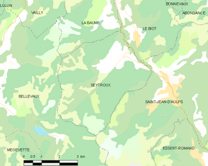
Seytroux
- commune in Haute-Savoie, France
Hiking in Seytroux
Seytroux is a charming village located in the Auvergne-Rhône-Alpes region of France, specifically in the Haute-Savoie department. It is situated in the heart of the French Alps, which makes it a fantastic destination for hiking enthusiasts....
- Country:
- Postal Code: 74430
- Coordinates: 46° 14' 58" N, 6° 37' 2" E
- GPS tracks (wikiloc): [Link]
- Area: 18.44 sq km
- Population: 487
- Web site: [Link]

Bonnevaux
- commune in Haute-Savoie, France
Hiking in Bonnevaux
Hiking in Bonnevaux, located in the Haute-Savoie region of the French Alps, offers breathtaking scenery, a variety of trails, and an opportunity to experience the natural beauty of the Alps. Here are some highlights about hiking in this area:...
- Country:
- Postal Code: 74360
- Coordinates: 46° 17' 49" N, 6° 40' 13" E
- GPS tracks (wikiloc): [Link]
- Area: 7.82 sq km
- Population: 265

Saint-Jean-d'Aulps
- commune in Haute-Savoie, France
Hiking in Saint-Jean-d'Aulps
Saint-Jean-d'Aulps is a beautiful mountain resort located in the Rhône-Alpes region of France, within the wider Portes du Soleil area. It’s an excellent destination for hiking enthusiasts, offering a range of trails and stunning alpine scenery....
- Country:
- Postal Code: 74430
- Coordinates: 46° 14' 5" N, 6° 39' 20" E
- GPS tracks (wikiloc): [Link]
- Area: 40.19 sq km
- Population: 1241
- Web site: [Link]