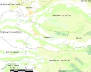
Le Fau (Le Fau)

- commune in Cantal, France
- Country:

- Postal Code: 15140
- Coordinates: 45° 6' 6" N, 2° 35' 3" E


- GPS tracks (wikiloc): [Link]
- Area: 19.46 sq km
- Population: 31
- Wikipedia en: wiki(en)
- Wikipedia: wiki(fr)
- Wikidata storage: Wikidata: Q275798
- Wikipedia Commons Category: [Link]
- Freebase ID: [/m/03mb78w]
- GeoNames ID: Alt: [6456735]
- SIREN number: [211500673]
- BnF ID: [15248237v]
- INSEE municipality code: 15067
Shares border with regions:


Le Falgoux
- commune in Cantal, France
- Country:
- Postal Code: 15380
- Coordinates: 45° 9' 19" N, 2° 37' 21" E
- GPS tracks (wikiloc): [Link]
- Area: 30.59 sq km
- Population: 128


Saint-Paul-de-Salers
- commune in Cantal, France
- Country:
- Postal Code: 15140
- Coordinates: 45° 8' 23" N, 2° 30' 59" E
- GPS tracks (wikiloc): [Link]
- Area: 36.57 sq km
- Population: 106

Fontanges
- commune in Cantal, France
- Country:
- Postal Code: 15140
- Coordinates: 45° 6' 49" N, 2° 30' 14" E
- GPS tracks (wikiloc): [Link]
- Area: 18.04 sq km
- Population: 205


Saint-Projet-de-Salers
- commune in Cantal, France
- Country:
- Postal Code: 15140
- Coordinates: 45° 5' 8" N, 2° 31' 36" E
- GPS tracks (wikiloc): [Link]
- Area: 36.32 sq km
- Population: 138