Le Houga (Le Houga)

- commune in Gers, France
- Country:

- Postal Code: 32460
- Coordinates: 43° 46' 30" N, 0° 10' 50" E


- GPS tracks (wikiloc): [Link]
- Area: 31.51 sq km
- Population: 1205
- Wikipedia en: wiki(en)
- Wikipedia: wiki(fr)
- Wikidata storage: Wikidata: Q921004
- Wikipedia Commons Category: [Link]
- Freebase ID: [/m/03nrq1c]
- GeoNames ID: Alt: [6455857]
- SIREN number: [213201551]
- BnF ID: [15255741z]
- VIAF ID: Alt: [139198011]
- MusicBrainz area ID: [4da897d0-8e83-4c51-b58c-d7decfd47fd4]
- INSEE municipality code: 32155
Shares border with regions:
Vergoignan
- commune in Gers, France
- Country:
- Postal Code: 32720
- Coordinates: 43° 43' 4" N, 0° 11' 54" E
- GPS tracks (wikiloc): [Link]
- Area: 10.44 sq km
- Population: 283

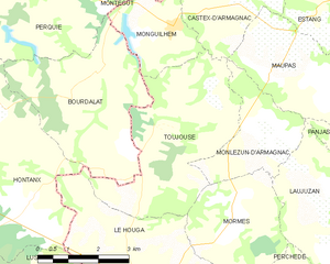
Toujouse
- commune in Gers, France
- Country:
- Postal Code: 32240
- Coordinates: 43° 49' 57" N, 0° 10' 44" E
- GPS tracks (wikiloc): [Link]
- Area: 14.5 sq km
- Population: 228
Perchède
- commune in Gers, France
- Country:
- Postal Code: 32460
- Coordinates: 43° 46' 36" N, 0° 8' 14" E
- GPS tracks (wikiloc): [Link]
- AboveSeaLevel: 128 м m
- Area: 5.25 sq km
- Population: 105
Magnan
- commune in Gers, France
- Country:
- Postal Code: 32110
- Coordinates: 43° 46' 8" N, 0° 7' 21" E
- GPS tracks (wikiloc): [Link]
- Area: 11.3 sq km
- Population: 247
Lussagnet
- commune in Landes, France
- Country:
- Postal Code: 40270
- Coordinates: 43° 46' 30" N, 0° 14' 2" E
- GPS tracks (wikiloc): [Link]
- Area: 8.43 sq km
- Population: 75


Hontanx
- commune in Landes, France
- Country:
- Postal Code: 40190
- Coordinates: 43° 49' 29" N, 0° 16' 26" E
- GPS tracks (wikiloc): [Link]
- Area: 30.48 sq km
- Population: 574


Cazères-sur-l'Adour
- commune in Landes, France
- Country:
- Postal Code: 40270
- Coordinates: 43° 45' 38" N, 0° 19' 3" E
- GPS tracks (wikiloc): [Link]
- Area: 31.25 sq km
- Population: 1060


Aire-sur-l'Adour
- commune in Landes, France
- Country:
- Postal Code: 40800
- Coordinates: 43° 42' 11" N, 0° 15' 46" E
- GPS tracks (wikiloc): [Link]
- AboveSeaLevel: 80 м m
- Area: 57.78 sq km
- Population: 6099
- Web site: [Link]
Luppé-Violles
- commune in Gers, France
- Country:
- Postal Code: 32110
- Coordinates: 43° 44' 8" N, 0° 8' 18" E
- GPS tracks (wikiloc): [Link]
- Area: 7.57 sq km
- Population: 163
Mormès
- commune in Gers, France
- Country:
- Postal Code: 32240
- Coordinates: 43° 47' 51" N, 0° 9' 15" E
- GPS tracks (wikiloc): [Link]
- Area: 9.05 sq km
- Population: 120
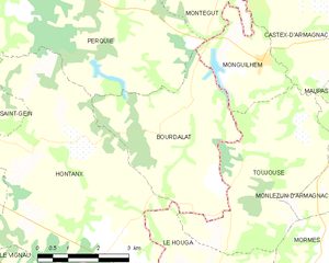
Bourdalat
- commune in Landes, France
- Country:
- Postal Code: 40190
- Coordinates: 43° 50' 22" N, 0° 12' 35" E
- GPS tracks (wikiloc): [Link]
- Area: 14.15 sq km
- Population: 246