Le Luot (Le Luot)

- commune in Manche, France
- Country:

- Postal Code: 50870
- Coordinates: 48° 45' 24" N, 1° 19' 10" E


- GPS tracks (wikiloc): [Link]
- Area: 8.5 sq km
- Population: 257
- Wikipedia en: wiki(en)
- Wikipedia: wiki(fr)
- Wikidata storage: Wikidata: Q923486
- Wikipedia Commons Category: [Link]
- Freebase ID: [/m/0h2t3_]
- Freebase ID: [/m/0h2t3_]
- GeoNames ID: Alt: [6456125]
- GeoNames ID: Alt: [6456125]
- SIREN number: [215002825]
- SIREN number: [215002825]
- BnF ID: [15262257f]
- BnF ID: [15262257f]
- INSEE municipality code: 50282
- INSEE municipality code: 50282
Shares border with regions:


Subligny
- commune in Manche, France
- Country:
- Postal Code: 50870
- Coordinates: 48° 44' 42" N, 1° 21' 57" E
- GPS tracks (wikiloc): [Link]
- Area: 8 sq km
- Population: 367


Saint-Jean-de-la-Haize
- commune in Manche, France
- Country:
- Postal Code: 50300
- Coordinates: 48° 42' 15" N, 1° 21' 39" E
- GPS tracks (wikiloc): [Link]
- Area: 8.95 sq km
- Population: 499


La Mouche
- commune in Manche, France
- Country:
- Postal Code: 50320
- Coordinates: 48° 47' 37" N, 1° 20' 59" E
- GPS tracks (wikiloc): [Link]
- Area: 4.43 sq km
- Population: 246
- Web site: [Link]

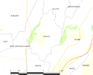
Chavoy
- commune in Manche, France
- Country:
- Postal Code: 50870
- Coordinates: 48° 43' 38" N, 1° 20' 1" E
- GPS tracks (wikiloc): [Link]
- Area: 3.7 sq km
- Population: 126


Le Tanu
- commune in Manche, France
- Country:
- Postal Code: 50320
- Coordinates: 48° 48' 59" N, 1° 20' 43" E
- GPS tracks (wikiloc): [Link]
- Area: 10.12 sq km
- Population: 376


Plomb
- former commune in Manche, France
- Country:
- Postal Code: 50870
- Coordinates: 48° 43' 49" N, 1° 18' 9" E
- GPS tracks (wikiloc): [Link]
- Area: 8.16 sq km
- Population: 394