Plomb (Plomb)

- former commune in Manche, France
- Country:

- Postal Code: 50870
- Coordinates: 48° 43' 49" N, 1° 18' 9" E


- GPS tracks (wikiloc): [Link]
- Area: 8.16 sq km
- Population: 394
- Wikipedia en: wiki(en)
- Wikipedia: wiki(fr)
- Wikidata storage: Wikidata: Q686994
- Wikipedia Commons Category: [Link]
- Freebase ID: [/m/03nxb9_]
- Freebase ID: [/m/03nxb9_]
- GeoNames ID: Alt: [6435533]
- GeoNames ID: Alt: [6435533]
- BnF ID: [152623807]
- BnF ID: [152623807]
- PACTOLS thesaurus ID: [pcrtkTMGDYm0JF]
- PACTOLS thesaurus ID: [pcrtkTMGDYm0JF]
- INSEE municipality code: 50406
- INSEE municipality code: 50406
Shares border with regions:


Braffais
- former commune in Manche, France
- Country:
- Postal Code: 50870
- Coordinates: 48° 45' 25" N, 1° 15' 40" E
- GPS tracks (wikiloc): [Link]
- Area: 5.79 sq km
- Population: 192


Tirepied
- commune in Manche, France
- Country:
- Postal Code: 50870
- Coordinates: 48° 42' 36" N, 1° 15' 50" E
- GPS tracks (wikiloc): [Link]
- Area: 18.77 sq km
- Population: 802

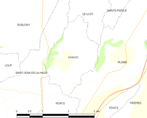
Chavoy
- commune in Manche, France
- Country:
- Postal Code: 50870
- Coordinates: 48° 43' 38" N, 1° 20' 1" E
- GPS tracks (wikiloc): [Link]
- Area: 3.7 sq km
- Population: 126


Ponts
- commune in Manche, France
- Country:
- Postal Code: 50300
- Coordinates: 48° 42' 12" N, 1° 20' 42" E
- GPS tracks (wikiloc): [Link]
- Area: 6.7 sq km
- Population: 615
- Web site: [Link]

Sainte-Pience
- former commune in Manche, France
- Country:
- Postal Code: 50870
- Coordinates: 48° 45' 50" N, 1° 18' 9" E
- GPS tracks (wikiloc): [Link]
- Area: 8.68 sq km
- Population: 318
- Web site: [Link]


Le Luot
- commune in Manche, France
- Country:
- Postal Code: 50870
- Coordinates: 48° 45' 24" N, 1° 19' 10" E
- GPS tracks (wikiloc): [Link]
- Area: 8.5 sq km
- Population: 257